Quantcast
Channel: The Mill Creek Hundred History Blog
Viewing all 331 articles
Browse latest View live

More About the McDaniel-Peach House

$
0
0
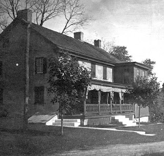
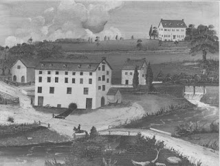
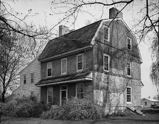
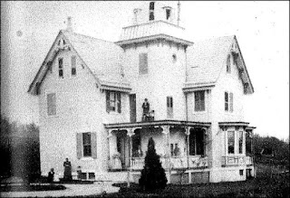
McDaniel-Peach House, 1910's
A while back I did a couple of posts about a pair of related houses -- the John McDaniel House and the McDaniel-Peach House. I had a few scraps of information about the John McDaniel House, but for the older McDaniel-Peach House I was left with little more than an old story and a heap of educated guesses. Recently (OK, my version of "recently" is "within the past few months"), however, I've been fortunate enough to have been contacted by several people with family connections to the McDaniel-Peach House. And while we still don't have all the answers, they were able to fill in a few blanks along the way. In the process -- in regard to the original post -- I managed to confirm one thing I wrote and refute another. And while we're here, we'll take a quick look at the industry that flourished for a time on the property.

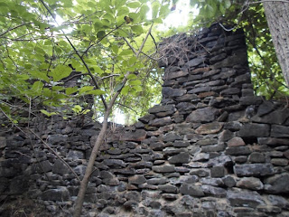
First, to quickly get everyone up to speed and recap the original post, the McDaniel-Peach House is located just north of Paper Mill Road, about half way between North Star Road and Limestone Road in the development of Chestnut Valley. I had speculated that it was built sometime before 1777 by James McDaniel, who may have been a descendant of Bryan McDonald, an early MCH settler in the area near Brandywine Springs. The 1777 date sprung from a story related by Francis Cooch in the 1930's, and later compiled in the book Little Known History of Newark, Delaware and Its Environs. (I'm happy to say I found the original version of  Cooch's article, printed October 16, 1932.) I believe that a few of the items graciously forwarded to me to share can shed some light on the construction of this home overlooking the Pike Creek Valley.

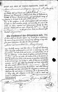
The first is a nearly 100 year old notation that, if correct, would slightly change this house's connection to that story of Hessian Aggression (like that?) during the march to Brandywine. (If you can't follow links, very short version: British (many Hessian) soldiers basically ransacked the house on their way to the Battle of Brandywine in 1777.) A close family friend of the Peaches (who owned it at the time), while on a visit in 1921, wrote in her address book, "Will Peach's house was built in 1782. The name on the datestone M & J McD. Mary & James McDannell." As far as the name goes, it confirms that it was James McDaniel who built the house. And "McDannell" seems like a plausible intermediate step between McDonald and McDaniel. The questions come with the date.

Obviously, if the house was built in 1782, it wasn't there to be ransacked by Redcoats in 1777. I can think of three possible explanations. The first is that the 1782 date is wrong. Although it's not clear if the date itself was on the datestone (sometimes they were just initials), I have no reason to doubt its accuracy. It's a pretty specific date and the house had basically stayed in the same family, so I'm inclined to take it at face value. A second possibility is that the house actually was built prior to 1777, and that the 1782 date memorializes a renovation or reconstruction of it. The third possibility I see is that the current house really was built in 1782, replacing an older one on the site. It would have been the older one, then, that was plundered by the British.

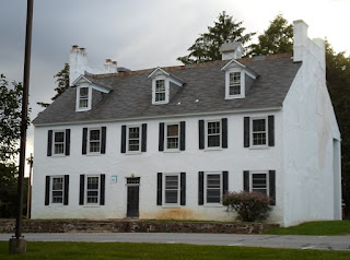
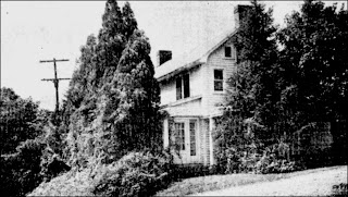
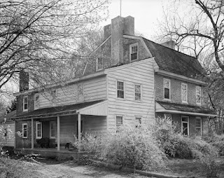
McDaniel-Peach House today

And as for the house itself, whenever it was built, I can now make a better assessment of it thanks to an old picture. I can also see that my original supposition was incorrect. The photo at the top of this post shows the McDaniel-Peach House as it looked around the early 1910's. Compare that to the current configuration of the house, as seen above. Without a good look at the home, I had guessed that the eastern part (on the right - the house faces south) was the original section. The old picture clearly shows that the western end is the oldest part of the house. I also think it shows that there have been several phases in the construction of the house. If you look closely at the old picture, you can see a line running down the roof, coming down to the near end of the two-story bay. That, combined with the seemingly interior chimney, leads me to believe that the section where the bay is was added at a later date to the original western portion. And since the three windows on that block don't seem to be symmetrical, it's possible that there was more than one phase to that part, as well. The entire eastern wing does not appear to be present in the 1910's photo (nor does it seem to be in the 1937 aerial shot, but that's very difficult to tell), so it must have been erected later. There's also a rear wing on the western end, but the old picture doesn't include that area so I can't be sure of its date. I would think it would be 19th Century, but it could also have been built at the same time as the eastern wing.

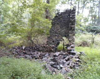
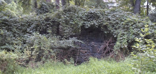
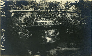
The final thing I wanted to share was a picture not of the house, but of the industry that was undertaken on the property for several decades -- kaolin mining. As with several other properties in and around Hockessin, kaolin clay was discovered on the Peach farm in the late 1800's. After discovering the valuable clay on their property in 1893, William Paul Peach and his siblings soon went about extracting and processing the material. They built a plant on-site and by 1899 had 35 people in their employ. The picture below is of the processing plant, circa 1920. The Peach family sold the business to an outside firm in 1916.


Peach Kaolin Clay Company

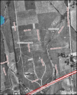
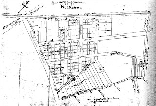
I have been unable to find any mention of exactly where the plant was, or from where the clay was mined. One source puts the plant "along Pike Creek", but I think that's a more general description of the property than of the plant. From studying the the 1937 aerial photos of the area, though, I think I might have a guess or two. I'll lay them out and see what everyone else thinks.

Peach Farm, 1937
In the picture above, the McDaniel-Peach House is in the upper center, just to the right of the words "Oakridge Ct". The white line coming up from the lower left is Paper Mill Road. If you'll notice, there are some white areas just above the road, in the area around what's now Renee Lane. I think those white spots are the clay pits. Modern aerial shots show a small pond just above Renee Lane, which I think is the remains of one of the clay mines. However, I can't see any sign of the plant in the 1937 aerial, so it may have been abandoned and razed by then.

I've also spent a good amount of time staring at the clay company picture, too. I can't find anything definitive to tell me exactly where we're looking, but I have a theory (yes, of course I do). Since the picture was taken by someone visiting the house, it makes sense that they would have been coming from there. I think the picture is looking south, with the house somewhere behind the photographer. This would put Paper Mill Road possibly on the other side of the trees beyond the structures. Interestingly, if this is true, then there's one other identifiable structure. In the upper right, you can see a white building. If the picture looks the direction I think it does, then this structure could be the large barn built by Abel Jeanes in 1832.

In any case, these new pictures and documents give us a bit more information about this historic property. I want to thank the contributors very much for passing these along to us.

Caleb Harlan -- Physician, Poet, Agronomist

$
0
0
Dr. Caleb Harlan
For any given area, you'll always be able to find a few people who stand out from the rest. Not necessarily for their talent or success (although those may come with it), but just because they seem to think a bit differently from those around them, or do things that others don't. One such person in Mill Creek Hundred a century and a half ago was Caleb Harlan. He was born to a family of farmers and millers, but ended up using his intellect more than his frail body for both his profession and his passion. He had the mind of a poet and a radical thinker, but always remained focused on improving the well-being of his fellow man, both physically and economically. His name is almost forgotten today, but there was a time when I'm sure almost everyone in the area knew Dr. Harlan.

Caleb Harlan was born on October 13, 1814 to John and Elizabeth (Quinby) Harlan, at their home in Milltown. John Harlan (1773-1851) was a Quaker miller who, along with brothers Caleb, Jr. and Joshua, owned and operated a mill along Mill Creek at the intersection of Limestone Road and Milltown Road. The "new" mill erected by the Harlan brothers in 1815, converted in the 20th Century to a residence, still stands today. No other homes from this era remain (the brick house next to the mill was built by a later owner in 1860's), but it's very possible that the Harlan house(s) stood on the east side of the old course of Limestone Road. This would place them right in the current path of Limestone Road, as changed in 1964.

The young Caleb, as Scharf relates, "inherited a very frail constitution" from his mother, which undoubtedly helped to instill in him a great interest in diet and wellness. This led to his enrolling at the University of Pennsylvania, at which he studied medicine and from which he graduated in 1836. After getting his medical license, Dr. Harlan took up residence near Brandywine Springs and practiced traditional medicine for the next 11 years. During that time, however, he became more and more interested in a new, alternative form of practice known as homeopathy.

Homeopathy is a form of medicine developed in the late 18th Century by German Samuel Hahnemann, namesake of Philadelphia's Hahnemann University Hospital. You can read much more about it here, but basically homeopathic cures are based on two rather dubious tenets. The first is the "law of similars", which is the idea that, "a substance that causes the symptoms of a disease in healthy people will cure that disease in sick people". The second has to do with the creation of the remedies themselves, which is done through a process of serial dilution. The remedies are diluted so much, in fact, that often no trace of the original substance is left. So while homeopathic cures are usually not dangerous, I think any effectiveness they might have is explained more by the placebo effect than anything else.

Although homeopathy seems to have made a slight comeback over the past few decades (along with many other "alternative medicines"), modern science has pretty much relegated it to the level of quackery. And while in reality it never was more than that in the 19th Century, it was what I'd call "honest, well-intentioned quackery". Its practitioners, of whom Dr. Harlan was one of the first in Delaware, truly believed in their cures and were seeking an alternative to the standard medical practices of the day -- practices that in the 1840's, to be honest, were probably closer to ancient tribal remedies than to the modern medicine we have today. Caleb Harlan certainly believed in the power of homeopathy, and in 1847 moved to Wilmington to practice it.

Unsurprisingly, the new practitioners of homeopathy faced a fair amount of resistance and opposition from the established medical field, which the homeopaths termed allopathy. In defense of his methodology, Dr. Harlan published a pamphlet entitled, "A Lecture on Allopathy and Homeopathy", which seems to have been well-received, at least by those inclined towards that philosophy. Eventually homeopathy did gain acceptance, and was a regular part of the medical scene for much of the second half of the century.

Harlan's pro-homeopathy pamphlet seems to have been his first published work, but it was far from his last. Given that homeopathy was probably the 19th Century equivalent to New Age or Holistic medicine, it's not surprising to me that Harlan had the heart of a poet. His first published work as 1860's Ida Randolph of Virginia: A Poem in Three Cantos. It was originally published anonymously, supposedly just for circulation amongst his friends. It was another 19 years before the publication of his greatest and best known (yes, those are relative terms) work, Elflora of the Susquehanna. Written, like "Ida Randolph", in heroic couplet, Elflora even spawned its own sequel four years later. In 1883, Harlan published The Fate of Marcel, a novel that furthered the adventures of the antagonist from "Elflora".

Interestingly, in the preface for "Marcel", Harlan says that both works were written early in the 1836-1847 period when he was practicing as a traditional doctor near Brandywine Springs. As he tells it, few of his neighbors were willing to solicit the services of a young doctor, especially one whom most had known as a boy just a few years prior. For a few years, he had little work as a physician, but lots of time to write. The action in "Marcel" is set in Mill Creek Hundred, in the woods around Red Clay Creek. He implies that some of the characters are based upon real individuals, with names changed to protect their identities. As you can see, I've included links to some of Dr. Harlan's works. I'm certainly no literary critic, but read them at your own risk. My own very uninformed feeling is that Wilmington was in no danger of losing its homeopathic pioneer to the international literary scene.

While much of what Caleb Harlan wrote was poetic and literary, perhaps his most important work was at the other end of the spectrum -- scientific. In 1876, he published Farming with Green Manures, on Plumgrove Farm. I'll save you from having to read it (although I do know one person who has -- bless you, Dave), and tell you that "farming with green manures" is not nearly as gross as it sounds. Essentially it's a more scientific approach to the old idea of crop rotation. It attempts to advise farmers on what cover crops to periodically plant in their fields, these cover crops then being plowed into the soil in order to enrich the soil and help it to recover. From what I've read of it, Harlan put a lot of time, thought, work, and experimentation into his work. He may have been a poet, but remember that he also studied as a physician, and was well-acquainted with scientific methods. "Farming with Green Manures" seems to have been a popular work, having been reprinted in at least 7 editions, at least as late as 1912 -- ten years after Harlan's death. The experimentation for the book was done on Plumgrove Farm, a property Harlan purchased in 1863. Much more on that in the next post...

Harlan did marry in 1841, to a young widow named Eliza Montgomery. They had three children -- two daughters and a son -- but all of them died relatively young, and without issue. His son John followed in his footsteps, receiving his medical degree from Hahnemann Medical College, and briefly joined Caleb in his practice. Sadly, though, John died little more than a year after graduation. So with all his accomplishments as a healer, poet, and agricultural writer -- but with no grandchildren -- perhaps Caleb Harlan's greatest legacy lies in one other contribution he made to the community -- one which is still very visible today.

The Harlans of Milltown made a number of marital connections to other prominent families in New Castle County. Caleb's Aunt Sarah married John Ferris, son of a wealthy Wilmington family. They had a son also named John, who died in 1882 with an estate valued at nearly $250,000. John Ferris chose his cousin Caleb as his sole executor and trustee. After settlement of Ferris' estate (much of which was earmarked for various charities), there was over $80,000 remaining, which Ferris essentially left for Harlan to spend on whatever benevolent pursuit he saw fit. Ferris did, however, suggest that one good use would be for the establishment of "a House of Refuge, or place for bettering wayward juveniles". Harlan took this advice to heart and gathered a veritable who's-who of wealthy and powerful New Castle County citizens to create such an institution. After purchasing the Woodside estate on Faulkland and Centre Roads, Caleb Harlan became the first president of the Ferris Reform School in 1885. The circa 1810 white house at the center of the campus is today known as the Harlan Building, in his honor.

The establishment of the Ferris School, which is still an important part of the community today, was perhaps the crowning jewel to Caleb Harlan's lifetime of service to others. Whether it was healing their bodies, trying to improve the output of their fields, bringing joy to the world through his writing, or looking after the well-being of troubled youths, his Quaker roots and poetic heart combined to create one of the most unique personalities in 19th Century Mill Creek Hundred.

Plumgrove Farm

$
0
0
In the last post, we took a fairly in-depth look at the life and works of Dr. Caleb Harlan (1814-1902), originally of Milltown. We touched on his family roots, his work as a homeopathic doctor, his poetic writings, and his instrumental role in establishing the Ferris School. To be honest, when I set out to write that post, that was pretty much all I had planned to write about. I either knew or had read little bits about all those topics, and figured that's all the post would be. However, while researching Dr. Harlan I did come across one topic that had eluded me before, and which was mentioned in the post. This in turn led to what I think was the most exciting part of the story, and one that, I believe, even ties into another one of our "ongoing investigations" here on the blog.

To be more specific, the subject in question is Harlan's 1876 agricultural treatise "Farming with Green Manures, on Plumgrove Farm". It's a highly thought-out and fairly scientifically-approached work that advises farmers on how best to use the idea of green manures on their fields. This process involves strategically planting cover crops in certain fields, then plowing this vegetation into the soil in order to replenish nutrients. The concept was not new in the 1870's (heck, it's really just a better version of the centuries old idea of crop rotation), but Harlan approached it in a very scientific way, always looking for better methods to use. The ideas he espoused in his book were not just theoretical -- they were based on years of actual experimentation.

As you could probably guess, this experimentation took place on a property owned by Harlan, known as Plumgrove Farm. There is little actual information (at least that we could find) about Plumgrove Farm, aside from a few basic facts. These are that Harlan purchased the property in 1863, and that it's always described as being "a few miles from the city". This would tend to narrow down its location to approximately most of northern New Castle County. There are, however, two other clues which seem to point to a specific location. First, there is (as far as I can tell) only one mention within the book itself that alludes to the location of the farm (not including references to features within the confines of Plumgrove itself). This comes in a remark about a field trampled by British soldiers in 1777, which sat, "In the north of Delaware, near the head-waters of Mill Creek and about three miles north-west of Plumgrove Farm...". Since we know Gen. Howe's army marched through northern MCH on their way to the Battle of Brandywine, this description fits pretty well with where Caleb Harlan's property is shown on the maps. Oh, did I forget to mention that it's on the old maps?


Beginning with the 1868 Beers map and continuing through the 1893 Baist map, there is a property labelled as "Dr. C. Harlan". As shown above, it lies just west of Mill Creek, directly south of Stoney Batter Road and east of Limestone Road. (The north-south road that runs alongside the farm has been abandoned.) For readers of this blog, if this area seems familiar, it's because I recently wrote about this property, although mistakenly so, because at the time I thought it was one tract over. If you check the 1849 map, the property is labelled as "J. Ball", which would have been John Ball. As outlined in the Joseph Ball House post, I believe John was, at the time, residing in the house now in Arundel. However, due to new information passed along by Walt C. (who has extensively studied old property records), I now agree with him that that house came slightly later to the family.

I now believe that the 103 acre parcel purchased by William Ball from his father John in 1735, and subsequently willed to his son Joseph in 1747 was this property, later bought by Caleb Harlan. The exact movement through, and use by, the Ball family of this property may be sifted through another time, but its leaving the Balls does fit the dates. Regardless of how they used it earlier, I think by the mid 1800's it was probably leased as a tenant property by the Balls. In 1861, the probable owner of both properties, James W. Ball, died. If the family were looking to sell the secondary farm then, it would likely put it available for Harlan to buy in 1863.

All this has, in my mind, two major implications. The first is that we now know exactly where Caleb Harlan did the experimentation that led to his influential book. The second is that we have a tangible link to a property occupied since at least the first half of the 18th Century. As I stated in the Ball House post, the wording of the 1747 will implies that there was a house on this property by that time, and Joseph very well may have moved into it before purchasing the tract to the south, present-day Arundel. But why would I say there's a "tangible" link? Well, because even though the farm has not been occupied for decades, at least, and is now completely surrounded by late 20th Century development, there are still traces of what may be 18th Century structures there.

Springhouse or root cellar

By studying the old maps, I had a pretty good idea of where the Plumgrove/Ball House should have been (and so could you), but I had no idea that there were any ruins. This fact was brought to my attention by Dave Olsen, who has been running and hiking through these woods since the early 1990's. As far as buildings go, there are at least three structures with visible remains, all constructed of stone. The first structure, slightly away from the other two, appears to be some sort of springhouse or root cellar. It's hard to see from the picture above, but it's reasonably tall and built into the side of a hill. Built into several of the walls are niches and contours, possibly used in the storage of whatever was held here.

The other two structures are just a short distance away, and would have been the heart of the farm. Although there's nothing to definitively identify them, both Dave and I agree that the smaller, less intact structure was the house. Just about the only thing remaining of the house is a portion of a corner, seen in the picture at the top of the post. In the thick undergrowth of summer, it was not possible to discern the perimeter of the structure to determine its size, but further investigation in the winter may yield better results.

The final building onsite is the largest and (relatively speaking) best preserved of the group. It was almost certainly the barn. Part of one wall and the foundations of the the other three are still present, and there appear to be window openings in the large wall. Measurements of the barn's size were not made, but could be at a later date. The pictures below give an idea of what is there.

Views of the Plumgrove Farm Barn
As you can see, not a whole lot remains of what was once Dr. Caleb Harlan's Plumgrove Farm. As best as I can tell, many of the fields were turning to forest by the mid-20th Century. Later in the century, suburbia crept in and filled the area with new housing. As for the old housing, unfortunately I'm not able to conclusively date the structures in the woods. Simply judging by the fieldstone construction, they look very old to me -- older than Caleb Harlan's tenure at the site. I think there's a good possibility that all three of these buildings date to the 1700's, maybe even to the early days of the Ball family's ownership of the property. If so, they may be somewhere in the range of 280 years old, and some of the oldest structures (partially) remaining in Mill Creek Hundred.

Two Abandoned Bridges in the Woods

$
0
0
Bridge over Turkey Run
This might not be the most exciting little post, but I wanted to write it anyway. There was something I had found a little while ago and shared with someone, but I realized I never posted it for everyone to see. Now I've come across another similar situation, so I figured I'd bundle them together in one post. At issue are two small bridges -- one repurposed and one abandoned -- in the woods near ruins I've been shown recently. These bridges were never very large or heavily trafficked even when in use, and are certainly not much to look at today. What this story is, I think, more than anything, is a neat way to use a reference source I haven't touched on in a while -- the 1921 State Highway Department Bridge Survey. Well, at least I thought it was neat. Your mileage may vary.

The first bridge in question goes back to the post about the Walter Craig House, which if you'll recall is located southwest of Corner Ketch, and just north of Thompson Station Road. In the post, I mentioned that the ruins are also near an old, abandoned road, visible on the old maps, that now serves as part of one of the trails through White Clay Creek Preserve. After having walked down this old road/new trail to get to the Craig House, and before going to the ruins themselves, my guide and suburbosylvan explorer (any chance that term'll catch on?) Roger Suro showed me the bridge that carries the trail over Turkey Run. The decking and upper portion of the bridge are new, presumably put in place by the state when the trail was created. However, if you look underneath the newer footbridge's decking and railings, you'll see a much older support system.


The wooden footbridge is actually sitting on the stone abutments and steel supports of the old bridge, as seen in the photo above. Once Roger pointed this out to me, I knew I had to try and find it in the 1921 survey. Not to get too far into the weeds (metaphorically speaking, not literally, which I did in checking out the bridges), but figuring out exactly where each bridge is in the survey can get a bit tricky. Since only major roads seemed to have official names then, most pictures are labeled not as being on a certain road, but as being near someplace. Luckily, (A) each bridge has a number identifying it and (B) I was able to find a current DelDOT bridge map with numbers, too. For the most part, where bridges are in the same location, the numbers are the same now as they were in 1921. In situations like these two, the numbers are usually not on the new map, but sometimes were reused for a nearby bridge. Also luckily, the numbers are more or less consecutive. In other words, bridge #215 is near #213, #214, #216, etc. With a little patience, you can figure out where an old bridge was, even if it's not on the new map. And speaking of Bridge #215, here it is below.

Bridge #M215, Near Thompson's Station
I'm not sure why they wrote what I assume was meant to be "Obsolete", since to me it doesn't look half as bad as many of the other bridges pictured. Maybe there was something about it in particular, or maybe the road itself was already being phased out by that time. Either way, I'm pretty confident that it's the same bridge. Even today, there are the remains of a gate to the right of the bridge, as seen in the lower picture. It looks like there is wooden decking leading to it, but I'm not sure of its purpose. If anyone has any ideas, feel free to comment.

Stone abutment of bridge near Plumgrove Farm

The second old bridge I found (or more accurately, bridge location) is back in the woods near Plumgrove Farm, east of Limestone Road and south of Stoney Batter Road. Whereas the last bridge still had the old substructure in place, this bridge is completely gone except for a stone abutment on one side. This bridge was situated on the road that formerly led south from Stoney Batter Road near the John Walker Farm, along the west side of Mill Creek, and coming out to Limestone Road near present Concord Drive (between Arundel Dr. and the McKennan-Klair House). Only the very northern part of it survives, as a long private drive to another old house (unless possibly Concord Drive is the southern tip). The road went past Plumgrove Farm and was completely abandoned sometime last century.

Just below where the road once passed in front the Plumgrove farmhouse, it crosses a small stream that nearby empties into Mill Creek (the stream probably has a name, but I don't know what it is). All traces of the bridge itself are long gone, but its former location was uncovered by that area's suburbosylvan explorer (see -- I'm not gonna give up), Dave Olsen. He found one of the stone abutments that once held the bridge, specifically the one on the north side of the stream. There are some stones on the opposite side, but erosion has destroyed any semblance of a structure there.

"Bridge #M188, Near Mermaid"
I believe that the photo above is of this bridge. As you can (sort of) see, it looks to have been a very simple wooden bridge. Frankly, from the looks of it, I think I would have been nervous going over it even with an empty wagon. Incidentally, the bridge number in this case, #188, was reused and given to a small bridge that crosses another Mill Creek tributary just to the south, in Arundel. The 1921 picture, in this case, doesn't really show much, but judging by location and number, I'm fairly certain this is it.

As you can see, neither of these bridges was very remarkable, even in their prime. Most people who go anywhere near them now probably don't even realize that they were once actual bridges on actual roads, such as they were at the time. I just think it's neat to use the 1921 Bridge Survey once in a while to locate some of these minor bridges, instead of the larger, flashier ones. While there were larger, fancier bridges around -- like the covered ones -- most 19th Century bridges were more like the ones here. Some on roads that survived were ultimately replaced by more modern structures (I have a feeling this was one of the reasons the 1921 survey was done, to identify what would need to be upgraded into the emerging Automobile Age), while others disappeared. Here were two bridges that had the misfortune of being on roads deemed unnecessary for the modern world, leaving only traces of their former "glory".

Abel Jeanes' Great Stone Barn

$
0
0
Aerial view of the Jeanes Barn remains
A while back, in what ended up being a series of posts (history, structures, lime kilns, Abel Jeanes), we took looks at several different aspects of the Eastburn-Jeanes Lime Kiln District. This turned out to be a fun topic to explore for a number of reasons. Among these were the facts that there is a fair amount of documentation about the area and the industry that went on there; that the families involved are pretty well documented (a process that continues today, right Donna?); and that the structures in the district are generally in a remarkable state of preservation. Except for the lime kilns themselves (which I doubt could be pressed into service now), there was only one structure mentioned that would fall into the "ruins" category -- Abel Jeanes' Great Stone Barn.

The barn was erected by Abel Jeanes in 1832 and sits sort of away from everything else, on the east side of Pike Creek. The general consensus for why Jeanes built it over there was to place it a safe distance away from any stray sparks that might escape from the lime kilns. Aside from its placement, the most outstanding feature of Jeanes' barn has always been its size. For many years after its construction, it was thought to be the largest barn in Delaware. It's not known exactly why it was built so large, but I put forth two possible explanations -- one serious and one semi-serious. My serious theory is that it was so big because of all the livestock Jeanes owned and needed to house. To do the heavy work of hauling around cartloads of lime, at the time the barn was built Jeanes owned 38 horses and 10 or 12 yoke of oxen. In this way I look at it as being as much a 19th Century parking garage as a barn. An alternate explanation is that from what we know of Abel Jeanes himself, he might have built the barn so large just because he could. He was not exactly what you'd call a shrinking violet.

To be honest, when I included the part about the barn being thought to be the largest in Delaware, I was really just including what had been written about it before. I'm sure there's no way to actually verify this claim, and I thought it may be no more than family or regional lore. Recently though (partially because I started thinking about it again after the McDaniel-Peach House post), I noticed that there was a way to access the ruins of the old barn, so I went over to take a look for myself.

The way I got to the barn was via a path through a short, wooded area. Not very long, but just enough to block the view of the ruins until you basically step out almost next to it. At the moment I first saw what was there, a couple of words escaped my lips, and they weren't "Holy Spirit!". Needless to say, I was quite surprised at just how large the barn was. After seeing it close-up, I'm much more inclined to believe that it actually was the largest barn in Delaware for years. Unfortunately, I didn't bring a tape measure with me that day, but by doing some rough estimates using the aerial photo scale, I'd say the barn is roughly about 100' x 70'. (I think my entire property could fit inside. Trying not to sound bitter, trying not to sound bitter...) The height is a little harder to judge, but I'd say 50' is in the ballpark.

Jeanes Barn circa 1932
But aside from just the numbers, as I thought about it, one other thing occurred to me that maybe more than anything else speaks to the scale on which Abel Jeanes built. The barn was erected in 1832, used throughout the remainder of the 19th Century, and likely kept in service right up until it was gutted by fire in the early 1940's. (The only photo of which I'm aware of the intact barn is from Cooch's "Little Known History", shown above.) I'm certainly no architectural historian, and maybe I missed something, but to me it doesn't appear as if the barn was ever enlarged or added on to. Pretty much every other barn I've looked at in the area had some manner of renovation and/or enlargement done to it as the 19th Century wore on, often in response to changes in the utilization of the farm (moving to dairy farming, for example). From what I can tell, Jeanes' original design for his barn was sufficient in scale to be used for over a century. To me, that's the most impressive part.

Just behind the barn I also noticed what looked like part of a much smaller, rougher stone wall. At first I thought this might be the remnants of a smaller outbuilding, but now I believe it's more likely that this was part of a ramp, or bridge, up to the upper level of the barn. It lies directly behind the large opening in the back wall.

The last thing that struck me was the excellent condition of what was there, considering that it's been nothing but stone wall ruins for 70 years. The barn is now on the property of the Independence School, and I assume that's who has been caring for it for at least the last 30 years or so that the school has been there. Whether it's the care it receives or the solid way in which it was originally built, the walls that remain seem to be in excellent shape.

Now with all that out of the way, let's get on to the good stuff -- pictures! By using the aerial picture at the top of the post, you should be able to orient yourself in my pictures below. Since the barn basically faces west, if you're looking at the front of it, then the back wall would be the east wall, left would be north, right would be south. The first picture is the initial view I described above, that surprised me as I came through the short, wooded path. Note that the last picture contains a record of the barn's ultimate demise. I hope these convey some of the scale of this impressive structure. Enjoy!

Exterior of the south wall


Interior of barn, toward northeast corner


Interior of barn, toward southeast corner

View from rear of barn, looking in toward front


Portion of interior of north wall, showing burnt timber

The Fell Historic District

$
0
0
Fell Historic District area, c.1860
A couple years ago (have I been doing this that long?) we took a brief look at the history of the Fell Spice Mill at Faulkland. In that post, we focused primarily on the history of the spice mill itself, and the Fell family who ran it. I mentioned, however, that there are several other aspects of the story that are worthy of their own posts. I think the most obvious are the surrounding buildings in the Faulkland area that comprise the Fell Historic District, entered into the National Register of Historic Places in 1983. There are eight buildings in the district, erected over a period of a century and a quarter, from 1800 to 1925. Some of them are visible from Faulkland Road, and some are not. You may even have driven by them without realizing their historic nature.

We'll now take a look at these eight homes (they weren't all homes to begin with, but they are now), which I've divided into three periods -- Early, Middle, and Late (original, huh?). There's more to say about some than others, but we'll touch on them all (with pictures!!). If you want to refamiliarize yourself with the basic history of the district, I recommend going back and reading the original Spice Mill post. That will hopefully make it easier to follow along with the names being used here.

Early Period


William Foulk's "Miller's House" today

The Miller's House: The oldest building still standing in the historic district is visible from Faulkland Road, just west of the creek. Known as "The Miller's House", this stuccoed fieldstone home was built by William Foulk soon after he consolidated ownership of the mill and property in 1798. During the Fell's tenure it was known as "The Farmer's House", as it served partially as the residence for the tenant farmer who worked the surrounding fields.

Miller's House on the right, c.1867

Miller's House with gable, behind burned mill, 1895

Foulk's old home has undergone several renovations and modifications over the years. According to Ken Shelin, his ancestors the Woodwards (who were employees at the spice mill), were occupying "the west half" of the Miller's house as early as 1833 (see comments section). This would seem to imply that it was being used as a double family home from the early days of the Fell's tenure here. In 1867, as shown in the top picture above, there was still only one front entrance. At some later date, a second front entrance was added, only to be removed when the house was changed back to a single-family dwelling in the 1940's. The house was damaged by what turned out to be the final mill fire in 1878. It may have been in the rebuilding afterwards that the cross-gabled roof and side addition (visible in the bottom picture above) were added.
 
William Foulk's Stone Barn, now a residence
 
The Stone Barn: Not long after building his home, William Foulk erected a stone barn along the road, down in front of his house. Whereas the house first appears in the records on the 1803 tax assessment, the barn pops up in 1816. Partially shrouded from the road by shrubbery and trees, its end wall sits very near the widened Faulkland Road. It was used by the tenant farmer throughout the 1800's, but converted into a residence in the 1950's.


Courtland Fell's 1836 Mansion
The Fell Mansion: By far the most impressive of the three Early Period edifices is the Fell Mansion, which sits a bit up the hill and away from the road. This Greek Revival home was built by Courtland J. Fell, soon after he moved to Faulkland in 1836. Courtland had been raised in Philadelphia, and presumably the older, smaller home of William Foulk was not up to his more refined tastes. Like the other two Early Period structures, it can be seen (along with the spice mill) in the painting at the top of the post. The five-bay symmetrical home is built of stuccoed fieldstone, and measures approximately 50' x 40'. Except for a kitchen wing on one end and a porch on the other, the house is little changed from Courtland Fell's day. With its up-to-date architecture and double-linked chimneys on each end, the house surely conveyed that Fell was a man of taste and means. It was also the last major structure erected in the district for about 30 years.

It remained in the Fell family until 1992, when it was finally sold off. By then the old home had started to feel the effects of its age, but was beautifully restored by the new owners.

Middle Period


The Gate House, Or Gatekeeper's House

The Gate House: The three Middle Period houses were all likely built by Franklin Fell, sometime in the mid-to-late 1860's. In fact, all three seem to appear on the 1868 Beers map. Franklin had retired from the day-to-day operations of C.J. Fell and Brother in early 1867, turning the family company over to his son, William Jenks Fell. Franklin continued to reside at Faulkland, however, and turned his attention to other business ventures. He was, for example, a major investor in the Wilmington and Western Railroad, and was named as one of the original VP's of the railroad. (The official groundbreaking for the W&W RR actually took place here, at Faulkland.)

Another of Franklin Fell's investments was his purchase, in 1869, of the Brandywine Springs Hotel and its property. His initial idea was to donate it to the Episcopal Church, but that deal was never finalized (a nice way of saying they didn't want it). Sometime just before this, and certainly prior to 1871 when they were described in insurance documents, Franklin built three houses on his property, all along Faulkland Road. These were built as tenant houses, to be leased either for a full year, or for the summer for visitors coming to Brandywine Springs (and presumably who didn't want to stay in the hotel. The hotel was pretty much at its lowest point then, and may have been bit on the run-down side).

The smallest of these houses is known as the Gate House, as it sits at the entrance to the "new" Fells Lane which replaced the old one when cars supplanted carriages in the early 1900's. It's a 1-1/2 story frame house, described as a Carpenter Gothic style. The Gate House has recently been restored by the owners, and probably looks as good as it did 140 years ago.

The Swiss Chalet double tenant house
The Swiss Chalet: By far the most architecturally unique of the tenant houses (and maybe of the whole district) is the Swiss Chalet. Facing Faulkland Road just up from the mill site, this striking red home is actually a double tenant house, used by the Fells in the same way as the Gate House. It stands now pretty much exactly as described by Franklin Fell in an insurance document in 1871. Like the other properties, it was sold off by the descendants of William Jenks Fell sometime in the 1940's or 50's.
 
Frame Tenant House
Tenant House: The final of the Middle Period houses is probably the most architecturally conservative of the bunch, but is no less appealing. It sits just below the Swiss Chalet, facing down the hill towards Red Clay Creek. It's a two story, three bay, frame house built on a stone foundation. The main block of the home is little changed from 1871, with only a rear ell added around 1900 and a side garage put on later. Like the other two Middle Period homes, this tenant house appears to be in excellent condition. So good, in fact, that I wonder how many people driving along Faulkland Road realize that these three homes were built 145 years ago to supplement the income of a 19th Century spice merchant?


Late Period


William Jenks Fell's 1894 Carriage House
 The Carriage House:  The final two elements of the Fell Historic District comprise what I call The Late Period, since they both date to a time after the dissolution of C.J. Fell and Brother and the end of spice milling along the Red Clay. The first of these two is the Carriage House, built by William Jenks Fell in 1894. The Carriage House sits up the hill from Faulkland Road, off of Fell’s Lane and sort of behind the Fell Mansion. It was built by William Jenks Fell to house his carriage, as well as the carriage attendant and family. By looking at the 1900 Census, it appears that the attendant at that time was an African-American named George Roberts (I’m fairly certain his occupation is listed as “Horse Man”, and he’s listed directly after the Fells). If so, then it was Roberts, along with wife Louisa, children Norris, Bessie, Walter, and Caroline, and mother-in-law Hannah Smith who lived in the Carriage House then.

The Carriage House is constructed of beautiful gray, rough-finished granite, built in the Romanesque Revival style. It's designed in a T shape, and I believe the near section in the picture was the portion that housed the carriage. When the structure was converted into solely a residence in the 1950's, the carriage door was enclosed with a large picture window. Since this is the side facing toward Fells Lane, I assume the square window with the lintel above was the carriage door opening. The house also retains some of its original stained glass, some of which I think can be seen in the upper window on the end of the carriage wing.

1925 Georgian Revival House
Georgian Revival House: The last, and newest, home included in the historic district could easily be mistaken at a glance as being one of the oldest structures. This is the large Georgian Revival house, situated at the end of Fell's Lane, past the Fell Mansion. Like its older neighbor, this home is a five-bay, fieldstone (although not stuccoed) house topped by three dormers. It was constructed in 1925 by a granddaughter of William Jenks Fell, and designed by her husband. I have to believe he designed his new home to complement the old family home next door.

There are two interesting architectural details about this house that I was tipped-off to recently by the mother of the house's current owner (thanks, Pat!). Both deal with elements of the house that were saved from older local structures and incorporated into this one. First, some of the stones used in the foundation were salvaged from the Yarnall Tavern, a colonial-era inn that sat on Newport Gap Pike just south of Faulkland Road. Also, one of the mantelpieces was rescued from the old hotel at Brandywine Springs, which in 1925 was on the verge of being torn down.

In a way, these help to bring full circle the story of the Fells in Faulkland. It was in large part due to Brandywine Springs that they were here to begin with (Jonathan Fell purchased the mill property after visiting Brandywine Springs and falling in love with the area). Now, in the last major structure built by the family, there are items honoring the area's earlier history -- Much as the Fell Historic District honors, in its own quiet way, the impact of a century of milling at Faulkland.


The house shown below was (I now believe incorrectly) identified originally in this post as being the Miller's House. The real identity of this house is unclear, but may be addressed in a future post. Sorry for the confusion.

A Fell House, possibly an early tenant house


The Interesting Owners of Woodside

$
0
0
Woodside
I know that this one, again, is technically a little outside of Mill Creek Hundred, but it's close and does have a connection. This particular topic came to my attention recently while researching the posts about Caleb Harlan and Plumgrove Farm. I had always figured that the Ferris School was built on land donated by Mr. Ferris, although until recently I had no idea who that might have been. As it turns out, though, the money to start the school came from John Ferris, but the property was purchased with that money by his cousin, Caleb Harlan.

The property that Harlan purchased, known as Woodside, of course has its own history prior to the founding of the school. I'm not interested here in going into too much detail about the very early years of the house, or details about the house itself, for that matter. If I find more about those topics, perhaps I could come back to that someday, but the focus of this post is in a slightly different direction. In particular, I want to look briefly at the last three men to own Woodside, immediately before Harlan's purchase and the founding of the school. (Unless someone owned it very briefly, I believe these are the last three owners.) While none of these men were from Mill Creek Hundred (and I think only one was technically from Christiana Hundred, where the property sits) or particularly impacted it directly, they're just interesting guys.

The only structure that remains from 19th Century Woodside is the house itself, which is really an impressive edifice on its own. It's a six-bay stuccoed stone house, topped with three dormers in the front. If you look back there, it is visible from 141 (Centre Road), the only bright white building amongst the red brick of the rest of the Ferris compound. There is very little that I was able to find about the origins of the house, except that it is said to have been built around 1810. From what I can put together of the history of this area, the land was owned in the late 18th Century by William Armstrong. Sometime after his death, the property was purchased by William Armor, who seems to have resided there until his death around 1828. If the house does indeed date to circa 1810, then it would appear that William Armor was its builder.

The property was sold at a sheriff's sale in 1828, but who the exact buyer was I do not know. It would appear, though, that the next resident at the estate was a member of one of the most prominent families in Wilmington -- the Canbys. Although Samuel Canby (1811-1875) was only 19 in 1830, the census seems to show him living at Woodside, with two slightly older men. Perhaps no family was more important to the early development of Wilmington than the Canbys, with only the possible exception of the Shipleys and Tatnalls. Samuel's great-grandfather, Oliver Canby, is credited with building the first substantial mill along the Brandywine River, in 1742.

Samuel Canby lived at Woodside for nearly thirty years, but he retained close ties with his family and his native city. Like any high-statured man of the time, he served on a number of boards of banks, businesses, and organizations. He did have at least one business connection in Mill Creek Hundred that I know of -- he seems to have taken the grain from his farm to the Philips (Greenbank) Mill to be ground, as an 1840's ledger book from the mill lists him many times.

Samuel Canby House, 14th and Market Streets

We do happen to know exactly when, why, and to where Samuel eventually moved from Woodside. In May 1858, Samuel's father, James Canby, died. Samuel, being the eldest living son at the time, inherited his father's home in Wilmington. This home was one of the nicest in the city, and was built in 1791 by Samuel's grandfather, also Samuel Canby. Our Samuel lived here the rest of his life, as did his daughter, Elizabeth Canby Rumford. After her death in 1938, the house was sold and razed. It was replaced by the H. Fletcher Brown Vo-Tech High School, which itself was later torn down and replaced by the Hercules Building.

When Samuel Canby sold Woodside, he did so to another non-native of this area, although this one was from a good bit farther away. Richard Boyse Osborne was born in Ireland in 1815, and came to the United States in the 1830's. He's listed in Philadelphia in the 1860 Census, so he may have purchased Woodside soon after that. In 1870, he's listed here. Osborne was a civil engineer by trade, specializing in railroad and bridge construction. He has several distinctions associated with him (such as building the first all-metal truss bridge in America, in 1845), but there's one that sticks out to me. And you may not look at Woodside the same way when you pass it. Richard B. Osborne helped invent Atlantic City.

I won't bother to go through all the specific details regarding the founding of the resort town, although if you are interested, this site and this article will give some more insight. The short version of the story is that about 1850, a physician living on the New Jersey coast saw the potential of having a seaside resort located only two hours from Philadelphia by train. This new resort town would be more accessible in several respects than the established Cape May, which is further away and was seen as more of an upper-class destination. All the doctor needed was someone with the know how to bring his vision to life. That's when he called in Richard B. Osborne.

Osborne almost single-handedly made the concept of a resort into reality. He laid out and designed the railroad line to the shore, the Camden and Atlantic Railroad. He acted not only as an engineer, but as a salesman as well -- there was no more outspoken promoter of the venture than Osborne. His civil engineering expertise came in handy at the end of the line, too. It was Osborne who laid out the plan for the new resort town, using a grid pattern to make navigation easier for the vacationers. And when it came to naming the new seaside resort, it was Osborne who insisted that it be called Atlantic City. About the only thing he didn't do was come up with the actual street names we all grew up putting houses and hotels on -- that was his partner and the original visionary, Dr. Jonathan Pitney.

After the ultimate success of Atlantic City (from which Osborne made lots of money), he continued to work on other railroads, including while he was residing at Woodside. He also lived in Philadelphia, and Woodside may have been more of a summer, country home for him. Osborne lived until 1899, but sometime in the 1870's he sold Woodside and moved away for good. Perhaps not coincidentally, the next owner of the big, white house was also a builder, this one from Wilmington.

Philip Quigley, like his predecessor at Woodside, was an engineer and builder who did a lot of work with railroads. And like Richard B. Osborne, there is one achievement in Quigley's career that stands above the rest, and may have been accomplished while he lived at Woodside, or just before. As you may know, in 1876 the United States hosted the Centennial Exhibition in Philadelphia, the first true World's Fair to be held in the U.S. While not designed specifically for this purpose, one of the major results of the Exhibition was to introduce the U.S. onto the world stage as a technological power. We got to show the world that we were not simply a nation of farmers, which is how much of Europe (meaning, "the important part of the world") viewed us.

Machinery Hall

The Exhibition itself was located in Fairmount Park, and spread over a number of buildings, the two largest of which were the Main Hall and Machinery Hall. It was in Machinery Hall that most of the technological marvels of the time were housed. Among the new inventions introduced to the world here were the typewriter and Alexander Graham Bell's new device, the telephone. And in case you haven't guessed it yet, the contractor in charge of building Machinery Hall was Wilmington's -- and Woodside's -- Philip Quigley.

Machinery Hall stood on the south end of Fairmount Park, just up the street from the Philadelphia Zoo and very near the present site of the Mann Music Center. The actual location is now the site of a pond. The building was 1402 feet long and 360 feet wide, and covered nearly 13 acres. (If you're so inclined, you can get more information about Machinery Hall and the rest of the Centennial Exhibition here.) Like almost all of the structures for the Exhibition (with the main exception of the Art Building, now known as Memorial Hall), Machinery Hall was removed not long after the Fair's end, although it held on until 1883, longer than most.

Philip Quigley retired in 1877, and it's possible that this is when he purchased Osborne's country estate. In any case, he owned it until he died in 1884. Scharf has more information about Quigley, also. The timing of Quigley's passing was fortunate for Caleb Harlan, though, who was looking for a location to set up a reform school with his cousin John Ferris's money. With the estate newly on the market, Harlan purchased the property for the purpose for which is still used. The house itself was used as an administration building, and for a time as the residence of the administrator of the school. It has recently been mothballed, but fortunately remains standing.

Woodside, 1940
I know this has gotten us a bit off of our normal MCH track, but as I started to learn who these gentlemen were, it just seemed too interesting not to share. That big white house sitting back from 141 is now just another place I look at a little differently -- now that I know a bit about some of the men who called it home.

Identify This Mystery Object

$
0
0
The Mystery Object
I have something I want to put out for everyone to take a look at. My hope is that maybe someone might know what the heck it is. It was found in the woods near an old farmsite (I don't want to say exactly where just yet, on the off chance it might be rare), and I have no idea what it is. It seems to be made of copper, judging by the coloration and discoloration. If I remember correctly, it's roughly about two feet long, give or take.

The catch here is that it may or may not have anything to do with the farm in which it was found. It's not very far from the barn, but it's sitting in a small creekbed. It may or may not be connected to some copper tubing that is visible nearby. The tubing comes out of the creekbank and may come from the barn as some sort of drainage system. Since the object is in this small creek, that, to me, at least raises the possibility that it could have been washed there from somewhere else, and have nothing to do with the farm. It could be an old car part for all I know.

Does anyone have any idea what this might be? Here are a couple more pictures. If you have any ideas, feel free to speak up.


The Inexplicably Famous Polly Drummond

$
0
0
Polly Drummond's Tavern today
Several times previously here on the blog, we've (directly or indirectly) uncovered the origins of, and the people behind, various road and place names in Mill Creek Hundred. We've hit things like Duncan Road, Brackinville Road, Little Baltimore Road, Loveville Road and McKennan's Church Road. Usually, the person behind the name is either a major landowner nearby, or a prominent figure in the community (like a preacher). This time, we'll look at a name (first and last) known by pretty much anyone who's spent any time living in or passing through Mill Creek Hundred -- Polly Drummond. And while she did live for a while in the area that bears her name, she was not a large landowner (by "large", I mean her property -- I have no idea about Polly's size) nor did she live there very long. Assuming the name started to be used while she was there, it's now been around almost ten times longer than she was.

The very short version of this post is that Polly Drummond, for a time, operated a small tavern on the hill that now bears her name. The dual challenge here is to A) find out more about who Polly Drummond was, and B) figure out why her name came to be attached to a hill that already had a name (the road, of course, was later named after the hill). For the first part, I think I've done a pretty good job of collecting more about Polly Drummond in one place than any other place I know of. I can pretty much follow her from cradle to grave, and I even have some more information about the tavern that made her "famous". As for the second part -- we can only speculate. Not surprisingly, though, I do have a few thoughts about it.

The first trick to learning anything about Polly Drummond is to know that when she was born, she was named neither "Polly" nor "Drummond". Mary Evans, however, was born in June 1789, probably in eastern Mill Creek Hundred, somewhere near Faulkland. Her parents were Theophilus and Esther (Barker) Evans. Theophilus (I'm sorry, but I just love that name) Evans happens to have been the brother of Oliver Evans, America's first great industrial inventor. At the time Mary was born, Theophilus, Oliver, and brother John all jointly owned a grist mill along the Red Clay, in which they had installed Oliver's new automated milling system. The site of this historic mill would later be the home to the Fell Spice Mill.

Mary (and in case you didn't know, "Polly" is a nickname for "Mary" -- actually it's a derivation of "Molly", another nickname for "Mary") probably grew up in eastern Mill Creek Hundred, and in August 1817 married James Drummond, with whom she had three children. Her children were Evan (1818-1843), Mary (1820-1890) and John Wesley (1825-1889). Mary and James had only just shy of nine years together, though, before James Drummond died in 1826, leaving Mary as a widow with three small children. The very first mention I've ever seen of Polly Drummond in the historical record comes from this time, just a few years after her husband's death. It comes from someone mentioned in the blog several years ago.

Marriage Certificate of James Drummond and Mary "Polly" Evans
 Rev. Patrick Kenny was a Catholic priest, born in Ireland, who almost single-handedly helped to establish the Catholic Church in Delaware. His home -- and home church -- was located at Coffee Run on Lancaster Pike, between Wooddale and Loveville. Among other things, Fr. Kenny kept a diary, portions of which were published in the late 19th Century. The pioneering priest mentioned Polly Drummond in at least two separate contexts. In late May 1829, he wrote, "Polly Drummond plagues me to sell her a strip to build a house...", which he was reluctant to do since "my remnant of land is so small". He did end up selling Polly two acres, although sadly I know nothing more about this.

 A few months earlier, in March 1829, Fr. Kenny writes, "My next Grog shop, Molly Drummond's sent me a note to stop the amount of chalks against M[ary] Cremer by deducting 79/100 from her, M. C.'s wages". I think this has to do with money Mary Cremer, Fr. Kenny's housekeeper, owed to Polly. A "Grog shop" would be a tavern, and I wonder if it was incorrectly transcribed, or if he meant "My next door Grog shop". The next year, on April 2, 1830, he wrote, "Patrick Haw [his handyman and a heavy drinker] asked me for horse Paddy to go to Polly Drummond's store to pay debts and drink whiskey". When he says "store", I'm not sure if he means she also had a general store, but it seems obvious that prior to moving to western MCH, Polly Drummond did run a tavern somewhere near, and most likely on, Lancaster Pike near Coffee Run. It's not clear whether she owned it or just ran it, or whether it was originally James Drummond's or if Polly started it after his death. (However, the Drummond entry from the Orphans Court Extracts would seem to imply that James didn't own a tavern when he died.) In any case, this seems like an exciting find, since I've not seen this fact mentioned anywhere else by anyone.

Although there seems to be no other record of Polly Drummond's first tavern, we can assume she operated it for about 10 years, until she moved a few miles west in 1838. Her new tavern (or inn or hotel -- the terms were all but synonymous at the time) was located on what was then known as Meeting House Hill, named for the original White Clay Creek Presbyterian Church, which was located just a few yards east of the hotel. This hotel had been built in 1834 by Robert Graham, likely the same Robert Graham who owned a house up near Corner Ketch. (There appears to be only one Robert Graham in MCH in the 1820, 1830, and 1840 Censuses.) It was located on the southwest corner of the north-south road from White Clay Creek Presbyterian to Corner Ketch, and the old east-west Coach Road that extended on to Milford Crossroads. The north-south road -- now called Polly Drummond Hill Road -- is still intact, although a 20th Century rerouting has moved the new road to the west of the tavern. The Old Coach Road has disappeared to the west, and was rerouted slightly south on the east. What was once a major crossroads is now near the end of two small dead-end streets.

Polly Drummond's Tavern in 1953

The hotel itself is still standing, although because of numerous renovations over the years it probably doesn't look much like it did in 1838, when Robert Graham sold it after only four years. With the recent completion of the first railroad line through the area, Graham may have foreseen the decline of the coach-stop tavern. The new owners (according to Francis Cooch in his Little Known History) were Polly Drummond, Rachel Evans, and Jane Evans. Rachel was Polly's sister. I can't find a Jane Evans, but Polly did have a sister named Ann who died in 1845. Cooch mentions that "Jane" is not on the later deeds, so it may have been her.

One interesting fact, already pointed out in a comment last year by Donna P., is that the sisters' purchase is probably a return of the Evans family to the area. The land on which the hotel stands was owned in the early 1700's by a Jonathan Evans. I can't find concrete proof of it, but it's likely that Jonathan Evans was Polly's great-grandfather. (Jonathan's son was Charles, whose son was Theophilus.) We can only assume that Polly was aware of this. Maybe that's why she moved to the area. Whatever the reason for her move, she remained here for 17 years. She finally sold the hotel in 1855 to Isaac Vansant, who lived in the John C. Vansant House located just west along the Old Coach Road. Cooch states that Vansant ran a store out Polly's old hotel, but for how long is unclear.

After selling her tavern to Vansant, Polly moved (I would guess directly) to Harford County, MD, just north of Baltimore. She appears there in the 1860 Census (she's always listed as Mary in the censuses), next door to her daughter Mary and son-in-law Hiram Ball, who had been living in Maryland for at least 16 years. Sister Rachel and brother Charles are also listed in Polly's household. Polly Drummond died September 21, 1867 (145 years ago to the day of the this post) in Maryland, and is buried there along with several other members of her family.

Polly Drummond's headstone
 Now that we know more about the person of Polly Drummond, I have to wonder just why her name came to be used to identify the hill on which her tavern sat. She didn't grow up there, she didn't own a lot of land, and she was only there for 17 years. Besides, the hill already had a name -- Meeting House Hill. So why did it become Polly Drummond's Hill? I think for two reasons. First, the old name was just that -- old, and out of date. The church had been moved to the bottom of the hill almost 100 years before. The old meeting house may have lasted for a while, but the hill's name probably was a bit out of date by that point.

But I think the real reason that the tavern-keeper's name stayed on was just because of her personality. Although she didn't own the hill, I think for those 17 years sheownedthe hill. From what little personal information we have of her -- like Fr. Kenny's references and the fact that she took someone to court to get her horse back -- she seems to have been a forceful personality. I imagine she was also probably well-liked and well-thought-of in the community, too. Whatever the reason, almost 160 years after her departure from the area, everyone knows the name of Polly Drummond.

The Beginnings of Roseville Park

$
0
0
Roseville Park, 1937
Because, yes, I am this easily distracted, I wanted to post a few things about the early days of Roseville Park. This was brought to my attention by a comment by Bill Harris, who linked to this article in the News Journal (link may or may not work for you). The gist of it is here:
Planning for the neighborhood of Roseville Park got under way off Kirkwood Highway in 1928, with a few homes done before the Great Depression idled the project and uncounted others nationwide.

The post-World War II boom saw many more homes built in the neighborhood – boasting the oldest continuous civic association in the state – and more recent building brought the total of homes to 179.

From its start, when Kirkwood Highway was two slim lanes, the quiet, almost-hidden neighborhood near Polly Drummond Hill Road – one of the state’s first subdivisions, if not the first – welcomed residents and guests with a brick wall with end post tops engraved “Roseville” and “Park.”
The point of the article was that part of one of those brick pillars had been found in someone's yard, and was rebuilt. A good article, and a good mention of a community that was older than I had realized. In my response to Bill's comment, I had expressed some doubt about the characterization of the development as having "gotten under way off Kirkwood Highway in 1928". (Leaving aside the facts that A) there was no Kirkwood Highway in 1928, and B) technically the road there even today is Capitol Trail, not Kirkwood Highway.)

I don't really have a lot more information about the early days of Roseville Park (named, of course, after the old cotton mill and mill community nearby), but I did find a couple things of interest relating to its beginnings. I figured it was easier just to put everything into a post.

The first thing I wanted to share was the 1937 aerial picture that I mentioned in my comment. If you look at it (above), you can see that the main streets (Laurel, Maple and Rose) appear to be laid out, but there's not much in the way of houses. I can see two, maybe three if the big white one is not a barn. I think those two are still there, but I'm not convinced that at least one of them doesn't pre-date the development.

Since there were not more than two or three houses standing as late as '37, I had my doubts about how much it had actually "gotten under way" in 1928. As it turns out, the 1928 date is, if anything, a little late. The newspaper ad below ran in The Sunday Morning Star on October 17, 1926.


The ad, I think, pretty much speaks for itself. It shows that lots were being offered for sale in October 1926, although, of course, we don't know how many they actually sold. The next spring they were back at it again, as shown by this ad, also from The Sunday Morning Star, dated May 1, 1927.


Despite the ad's claims, I don't think houses were quite yet "springing up here and there", and it never exactly became a city. I'd be curious to know how many lots they did sell. I have a feeling that this venture, like countless others, was derailed mostly by the events of October 1929. It seems reasonable to assume that there was little development done on the site between then and 1946 at the earliest. That being said, when construction did restart after the war and the great suburban migration began, Roseville Park was probably well set-up to get in on the early action. And unlike earlier developments like The Cedars which were basically trolley suburbs, I would believe that Roseville Park was one of the first developments in the area planned strictly with the automobile in mind. It seems like, through no fault of its own, it stayed more or less in the planning phase for about twenty years -- more of an idea than a neighborhood. Once the world got back to normal, though, it turned into a pleasant little community that's now been home to several generations of Mill Creek Hundred families.

The Stanton Mills and Stanton-Byrnes House -- Part 1

$
0
0
One thing I've found while doing my research -- and I have a feeling it holds true for some of you, too -- is that not all historic sites generate the same feelings in me. Don't get me wrong, I think they're all interesting. It's just that some seem to "stick with me" more than others. It might be because it's in an area I'm more familiar with, or because I find its story more interesting, or it might just be aesthetically pleasing to me. One such site that's always fascinated me is the old Stanton Mills site and the house that stood near it. They were located just south of Stanton, down towards the end of what's now Mill Road. The road, which is really an extension of Limestone Road south of Route 4, stops about half way now, but once extended almost to where Red Clay Creek empties into White Clay Creek.

So if I'm so fascinated by this site, you might ask, why has it taken me so long to write about it? Well, basically because the information about it always seemed rather confusing to me. The mill was in operation for over 200 years, but was destroyed well over 100 years ago (think about that for a moment). In cursory searches in the past, I was never able to find much about it. But as I dug some more, I came up with a decent amount of information, testified to by the fact that this ended up as a two-part post, where I wasn't sure at first that I'd have enough for one. There are still a few gaps in the story, but I now have a much clearer notion of the history of this fascinating site.

One of the reasons this site has special interest for me is that it reaches back to the very early days of European settlement in the area. In fact, the mill erected here may very well be the first one in operation in what would become Mill Creek Hundred (the Greenbank Mill might precede it by two years, but that's far from certain). Scharf (who does call it "the earliest mill in the hundred") tells us that the mill was built on land owned by Charles Rumsey and John Watkins, and was built by a group of their neighbors. On October 14, 1679, Rumsey and Watkins agreed to let the nine subscribers erect a mill on their land. These nine were: John Smith, Thomas Wollaston, Abraham Man, Joseph Barnes, Arent Jansen, Olla Thomason, Jacob Jansen, John Nommers, and Henry Gerritsen. As you can see, they were a mix of Englishmen and Swedes/Finns. Scharf even includes a portion of the original agreement.


It appears from the wording that the mill these settlers (and remember, this area was basically "the frontier" at the time) built was a saw mill. If there was an influx of new settlers in the area -- all looking to build houses and barns and who-knows-what -- it would make sense to have a saw mill to provide them with freshly-cut lumber. Unfortunately, most of the next 100 years of the history of this pioneering mill is pretty much blank. A little can be deduced, though. It appears that early on, there was a bit of consolidation going on with the ownership of the mill. Before his death in 1686, Thomas Wollaston (claimed by Scharf to be perhaps the first settler in MCH) gained control of half of the mill. In 1705, his widow sold his half share to Cornelius and Richard Empson. Cornelius Empson (Richard was likely his son) was one of the most prominent landowners in New Castle County at the time, with multiple holdings totaling over 700 acres. He was also one of the founders of the first Friends Meeting in Delaware, in Brandywine Hundred.

When Cornelius died in 1710, he willed his half of the mill to his daughters Sarah* and Elizabeth. Unfortunately, there is very little if any mention of the mill for the next 50 years. This is especially frustrating because in that time period, a beautiful 2-1/2 story, gambrel-roofed, brick house was constructed on the property, not far from the mill. There seems to be no mention of who owned the property at the time, or who built the house. The only clue was in bricks on the south gable end of the house. There was found, "S W A 1740" in a pyramidal shape, with the "S" in the top row, "W A" in the middle, and "1740" on the bottom. That the house was built in 1740 seems straightforward enough. "W" and "A" are certainly the first initials of the owners, and "S" is their last initial. Everywhere I look, this is surmised to be W. Stanton -- presumably William. The only problem is, I can't find an mention of there being a W. Stanton. I assume he would be related to (father, perhaps?) Stephen Stanton*, for whom the town was eventually renamed. At this point, I honestly don't know if there is any actual evidence that the builder was Stanton (William and Ann, maybe?), or if this is just a "best guess" passed down through the years.

For most of its history, the actual occupant of the house has been even more difficult to discern than the owner. This is because the mill property on which it sits has gone through many hands, often with multiple owners, and often with absentee owners. The next mention comes in 1762, when the mill and property (including the house) were sold at a sheriff's sale. The owners at that time were Thomas Garrett (of the Yorklyn Snuff Mill Garretts) and George Robinson, a carpenter. Robinson was likely Garrett's brother-in-law. Whether it was added by Garrett and Robinson or someone earlier, by 1762 the original saw mill was working alongside a merchant (flour) mill, as well.

The purchaser of the mills in 1762 was a man from Chester County, PA, by the name of Richard Jacobs, Jr. Jacobs operated the mills for eight years, until he sold them in 1770 to two Philadelphia merchants -- Stephen Stapler and Samuel Smith (making them undoubtedly the most alliterative millers in the hundred). Jacobs had added a few smaller lots to the 107 acres he bought in 1762, ultimately selling 116 acres to Stapler and Smith. It would be Stapler, Smith, and another partner who would add the feature most readily visible in the 21st Century -- the long millrace.

Stapler and Smith were obviously looking to upgrade the mill, because within a couple years of purchasing it, they began construction of an enlarged millrace -- about a mile and a quarter long. The millrace, which runs down the west side of Red Clay Creek, begins at a dam all the way up by Kiamensi, just below Kiamensi Road and the former Kiamensi Woolen Mill. For much of its first stretch -- running in the woods behind Powell Ford Park -- the millrace is still visible, two hundred forty years later. In fact, that particular stretch is still to this day a separate parcel, dating back to 1772 when Stapler and Smith purchased the 60 foot wide length for their race.

Millrace parcel shown to the right of the ballfields

Stapler and Smith were not alone in their venture, however. Very early on (I think from about 1772) they were joined by another Quaker, Caleb Byrnes. Byrnes had moved to the area by March 1773, and his son later wrote that he purchased the mill along with Stapler and Smith. Although the first direct evidence of Caleb's involvement is a 1780 purchase of a 1/4 share in the mill, he was likely a partner well before that. About the same time Caleb moved here, his brother Daniel Byrnes purchased the brick house and mill nearby on White Clay Creek -- now called the Hale-Byrnes House. It's not clear if Stapler or Smith ever lived in the Stanton area, but we know for sure that Byrnes did, probably occupying the brick house built by the mysterious W.S.

It appears Byrnes remained at the mill until his death in 1794. The following year, his heirs, along with Samuel Smith, sold their half share of the mill (presumably Smith had 1/4 and Byrnes had 1/4) to Joshua Stroud. Stroud was undoubtedly no stranger to the mill, as he was married to Martha Byrnes, Caleb's daughter. In 1804, Thomas Stapler is listed as being half owner of the mill. I don't think he was Stephen's son, but may have been a brother. Thomas Stapler died in 1810, leaving his two quarter shares to his sons, Stephen and John. (Scharf identifies Stephen and John as the first Stephen's grandson's, but I think that might be incorrect.) So as of 1810, the mill was owned by Stroud (1/2 share) and Stephen and John Stapler. In 1812, John Stapler sold his share to his brother Stephen. The following year, Stephen Stapler consolidated ownership of the mill by buying the remaining half from Joshua Stroud.*

Consolidated ownership didn't seem to work out too well for Stephen Stapler, because in 1816 the mills were seized by the sheriff and sold to James Brian. Brian was a wealthy shipper in Wilmington, who also happened to be John Stapler's father-in-law*. Brian died in 1817, with John Stapler carrying on his business (probably why John sold his portion of the mill). It was then likely James Brian's estate (possibly John Stapler) who sold the Stanton Mills in 1820. It now consisted of "a merchant mill, a saw mill, and all machinery, buildings and tenements, and fifty-four acres". The new owner of the Stanton Mills was Samuel Bailey, who would usher in the final and most productive era of their operation. We'll take a look at that period in the next post.


Additional Facts and Related Thoughts:
  • There is another connection between the Stanton Mill and the Greenbank Mill. Cornelius Empson's daughter Sarah married Thomas Bird. Bird, at some point, purchased the Greenbank Mill. He willed it to his and Sarah's son Empson in 1726. It was Empson Bird who sold the mill to Robert Philips in 1773.
  • For that matter, I can't really find much in the way about Stephen Stanton, either. And to confuse things even more (you're welcome), writing in 1842 the son of Caleb Byrnes says the town was named for Daniel Stanton. If I had anything to offer, I'd put out a bounty on any information about the Stanton family in the 18th Century.
  • I have a feeling there's more to the story of Joshua Stroud. In May 1812 he sold his half of the mill the Jonathan and Daniel Byrnes, the sons of Caleb Byrnes. The next month, he bought it back. Seven months later, he sold it for good to Stapler. He apparently moved to Wilmington, as he was enumerated there in the 1820 Census. He may have moved back to Stanton, though, since I found that he died in 1834 at "Red Clay Mills", and was buried at the Stanton Friends Meeting. His father was probably the James Stroud who built the house later used as the Stanton Hotel.
  • I found some more interesting information about John Stapler and his family. One of John and Ann Brian Stapler's children was a daughter named Mary. In 1844, Mary Brian Stapler married John Ross. Who was John Ross? He was the Chief of the Cherokee Nation from 1828-1866. Here is an account of their story from a descendant. Bet you didn't know a girl from Wilmington was married to a real life powerful Indian Chief? She's buried in Wilmington, as was he originally. He (and John Stapler, among others) is now buried in Oklahoma.

The Stanton Mills and Stanton-Byrnes House -- Part 2

$
0
0
In the last post, we looked at the first 150 years or so of the history of the mills and house that sat south of Stanton. We tracked it (as well as possible) from its beginnings in the 1670's until its sale from the estate of James Brian to Samuel Bailey. One pattern that arose (and is shown in the Brian-Bailey sale) is the fact that the mills were very often "foreign owned". By this, I mean that unlike some of the other mill complexes in the area, the Stanton Mills (from probably sometime early in the 1700's) were owned by people who either didn't reside near the mills, or who lived here for only a short time. This, again, is one of the things that makes figuring out who lived in the brick house a bit difficult. I think that much of the time, it was a contracted miller, not the mill owner, who probably lived there.

But back to our story, in 1820 the Stanton Mills were purchased by Samuel Bailey. He was the son of Joseph Bailey, one of the most prominent and well-connected men in Wilmington. How well-connected? His father-in-law was Joseph Tatnall, who may have been the most famous person in the city's first 200 years. Elizabeth Montgomery mentions that Joseph Bailey "succeeded in the drug business", so he may have made his money originally as a druggist. From 1810-1841, he served as the President of the Bank of Delaware. He and his son Samuel probably knew James Brian, and knew of the Stanton Mills. Scharf says that after buying the mills, Samuel Bailey built a new frame mill, presumably to replace the old stone structure. If the stone mill he mentioned was the original mill, it would have been over 140 years old at that point.

Thanks to several newspaper sale notices found and forwarded to me by Donna Peters (thanks Donna!), we have some descriptions of what the mill was like, and what was present, in the 1810's. Below is a notice that appeared in the American Watchman on January 13, 1816. This is the sheriff's sale where ultimately James Brian purchased the property.


Sheriff's Sale notice, January 13, 1816

Since it's unlikely that Brian had a chance to do much with the mills (in fact there's another sale notice from him in December 1817), this is probably what was there when Samuel Bailey took over. We get another glimpse into the operation a dozen years into Bailey's tenure, which gives us some more information. The 1832 McLane Report has an entry from Bailey, from which we can learn a few things (besides the fact that he spelled "Stanton" as "Staunton"). First that they produced flour, kiln-dried corn, quercitron bark, and lumber, as well as making barrels and hogsheads. The other piece of data that I think shows the extent of the operation is the fact the at his Stanton (or Staunton) Mills, Samuel Bailey employed 23 men. That number undoubtedly included the mill and the cooper shop, which made the barrels and hogsheads. There seems to have been quite a bit of action taking place down by the mouth of the Red Clay 180 years ago.

Samuel Bailey is found living in Stanton, quite possibly in the brick house by the mill, in the 1830 Census. Even through the difficult economic times of the era, Bailey seems to have been fairly successful with his Stanton Mills. In 1845, he successfully petitions the State of Delaware to incorporate his mills. According to the Act to incorporate, the mills are "occupied by Joseph S. Bailey". Joseph S. Bailey was Samuel's son, and it appears he may have been living at, and overseeing, the mills then. A look at the names of the "commissioners to receive subscriptions to the stock of the company" shows a few names familiar to those who know Wilmington history: Price, Lea, Canby, Wilson, Starr and others. A few years later, another well-known (and already mentioned) Wilmington name will come into play.

1851 Sale Notice from Samuel Bailey

In 1852, Bailey sold the mills to the company of Tatnall & Lea, which had been the preeminent milling firm in Wilmington for nearly a century. Started by Joseph Tatnall -- Samuel Bailey's grandfather -- the firm in 1852 was led by William Lea and Bailey's cousin, Joseph Tatnall. When Tatnall & Lea broke up in 1864, control of the Stanton Mills went solely to Joseph Tatnall and the newly-formed Joseph Tatnall & Company. Although the property is shown with his name on the 1868 and 1881 maps, it's highly unlikely that Tatnall actually lived there, since he's listed in Brandywine Village (Wilmington) in every census. It's unclear whether either lived in the brick house, but in 1860, the millers seem to be Thomas Jones and James Barton. A deeper study of census records could reveal the names of other millers who worked here for Tatnall & Lea and for Joseph Tatnall & Company.

In case you ever wondered how much they made

Tatnall turned out to be the final owner of the Stanton Mills, however. In November 1885, a fire destroyed the millseat that had been operating for over 200 years. The house and property survived as a farm, but the mill was never rebuilt. With the growing industrialization of the milling industry and its inevitable move westward, relatively small sites like Stanton were on their way out already. Even in Wilmington, the golden age of milling along the Brandywine was coming to a close.

Stanton, 1881, showing mill in bottom right
Similar to an earlier period, after the fire there is a considerable gap in the record for the property. While the mill burned in 1885, the house definitely remained. What became of some of the other buildings like the cooper shop and the storehouse is unclear. One possibility is that they were ultimately taken down and the materials reused for other buildings. The final account we have of the property comes from Esta Donaghy, sister-in-law of blog reader and commenter Ken Copeland (big thanks to both Esta and Ken!). As a child in the 1960's, Esta and her friends often played in and around the various buildings on the property. From her descriptions, it sounds like it was a great place for a kid to play.

The property had been purchased around 1940 by Mr. and Mrs. Walter Pyle, when it was in ruinous condition. The Pyles evidently put a lot of care and work into the 200 year old home, because by the late 1950's it was in very good shape. By the early 60's, Esta remembers them as a very nice, elderly couple who sat on their front porch (which must have been added after 1958) and "would tell us stories and give us goodies". The Pyles told the kids stories of finding Civil War money hidden in the walls, and of things moving for no reason in their "haunted" house. They welcomed the children, who spent lots of time playing on the property, around the apple trees, and in and around the various buildings, like the three-story barn and the Pyle's chicken house.

About 1965 or '66 the Phipps family moved into the house, possibly as renters. They did have young children, so the old mill property stayed a big playground. Sometime around 1970, the big barn was destroyed in a fire. Esta believes the Phipps family moved out a few years after that, and the property may have been vacant thereafter. Not too many years later (so maybe around 1980??) the old brick house, like the mill and barn before it, fell victim to a blaze. By 1986 the Arbor Pointe Apartments were going up on the grounds, encircling the site of the house.

Today, almost nothing remains of the site occupied and worked for 300 years. Esta recalls finding the remains of a stone building in the woods in the '60s, which could have been the mill or the cooper shop. (Even if they were frame buildings, they could have had stone foundations.) I took a walk back through the area recently (there are trails through the woods which are accessible from the apartments), but I was not able to find any traces of structures. Back there now, there is no indication that this was once a hub of activity reaching back more than a century before American independence.

"Stanton"-Tatnall-Byrnes House Mystery Solved?

$
0
0
The Sutton-Tatnall-Byrnes House?
I have a lot of fun doing research for this blog, and just as much fun writing it. If you catch me on the right day, I might even admit to being proud of it. I like the fact that I've helped to make a good bit of our local history accessible to more people. That being said, I'll be the first to admit that most of what I do is usually just gathering, compiling, sometimes fact-checking, and repackaging work that was done by others before me. To be fair, though, I do always try to add value where I can, whether it's adding a little bit of background or tying together a few threads from different sources (almost never does one source have all the information). Once in a while, though, I get to make what feels like an actual contribution to our collective knowledge.

Now, I'm not saying that these contributions are on the scale of unearthing the Holy Grail, deciphering Linear A, or finding an original copy of the Declaration of Independence, but they're contributions none the less. It's at least locally significant -- and pretty cool -- to realize that we've uncovered or figured out something that no one else may have known for several hundred years, not since the original actors in the story. As you've probably guessed, I think we've (mostly not me) found another piece of "new" information.

In the post about the Stanton Mills and the brick house that once stood near them, I expressed some doubt as to the "accepted" builder of the house. The home seems to have been built about 60 years after the first mill was erected about 1680, presumably by someone connected to the mill. And although the house outlived the mills by almost 100 years, not coming down until about 30 years ago, no one seems to really know who built it. The only clue was some glazed brick headers on the south gable end of the house, arranged like so:

                    S
                 W A
                17  40

There's little doubt that this memorializes the builders of the house, as well as the building date of 1740. This format and style were common at the time, and it probably was similar to what William Cox put on his 1726 house near Hockessin. This would mean that the builder was "W S", along with his wife "A". The Historic American Buildings Survey (HABS) report written in the 1960's states that this "probably refers to W. Stanton", but gives no reason for this assumption. I don't know when the idea that the "S" was Stanton originated, but in the 1930's Francis Cooch referred to this house as being the home of AW Stanton. Not only did he get the initials backwards, but I think he was wrong all the way around. It's possibly, though, that he was only repeating the story he had been told by people in the area.

As I wrote in the other post, this explanation just doesn't seem right to me. For one thing, I can't find an evidence that there was a W. Stanton. This alone, though, doesn't disprove anything, since we're dealing with a period long before censuses and with spotty documentation. And again, I still haven't found proof of a Stephen Stanton, for whom the town was supposedly renamed, in the area. There does appear to have been one in Pencader Hundred, but not near here. I suppose he could have been a wealthy man who owned land near the village of Cuckoldstown, but it seems odd to me that the inhabitants would rename their town after someone who doesn't even live there. If any more information on this surfaces, I'll be sure to pass it along.

But getting back to the house, the explanation of the S as being Stanton smacks of revisionism to me. Like at a later date (long after the actual people had died) some decided, "S, on a house near Stanton -- has to be Stanton". If we set aside that assumption and start from scratch, then we're looking for someone with a last name beginning with S who owned (or partially owned) land near the mill about 1740. Thanks to some great detective work by Walt C. -- master of dusty, confusing Colonial-Era deeds and land documents -- I think we have a pretty good candidate.

As Walt was digging through abstracts and surveys from southeastern Mill Creek Hundred from the late 1600's and early 1700's, he came across an interesting chain. Abraham Man (one of the original signers for the mill) owned a large tract along the west side of Red Clay Creek, extending from present-day Stanton up through Marshallton.* The southern 200 acres of the tract eventually went to William Guest for repayment of debts. After Guest died, his widow received the land in 1717. Walt thinks the Widow Guest remarried to Nathaniel Wainsford, and that the two of them sold 7 acres of this land in 1737.

The man to whom they sold the 7 acres was William Sutton. His wife's name was Ann. Neither Walt nor I have yet found a good piece of conclusive proof that Sutton was the one who built the house, but it seems to make more sense to me. Plus, we have the bonus of knowing for sure that Sutton was, in fact, a real person.

I haven't come across anything else yet tying him to the Stanton property, but his name does pop up nearby. Scharf relates that Sutton was one of the original purchasers of lots in the new village of Newport Ayre, later shortened to simply Newport. Along with Joseph Jones, Sutton built the first wharf in the new village, starting the shipping trade that would help the town to grow.

The Joseph Tatnall House, Newport

Interestingly, Sutton and Jones' property was likely along the Christina River right about where the pigment plant is now (I think it's BASF currently, was Ciba, DuPont, and Krebs before that). On that property stands a house tentatively dated to 1750, officially called the Joseph Tatnall House. It's often incorrectly referred to as the Oliver Evans House (Evans never lived there, his family's home was on the west side of Newport). Sutton and Jones supposedly built a dwelling and a storehouse on their property, and the Tatnall House* is actually of a similar style to the one by the Stanton Mills. It was enlarged later in the 18th Century to five bays, but the original section was the two eastern (near side in the picture) bays, making it a similar size to the Stanton house. There is no evidence as to who built the Newport home, but I find the similarities interesting.

So while there's no conclusive proof (yet) that William Sutton built the house, I think it's the most likely scenario. The last question, then, would be why he built it. It's unclear what if any relationship Sutton might have had to the mill. In fact, if I'm reading the evidence correctly, it seems that the house lot was separate from the mill at the time. Did he build it for himself and his family to live in? He seems to have been (business-wise, at least) centered in Newport. The Stanton house isn't so far away that he couldn't have lived there, but since he was literally invested in the new town I'd think he'd choose to live there. Did he build it for a family member? Did he build it as a tenant house? One possible answer -- lots more questions.


Additional Facts and Related Thoughts:
  • I don't know that I've mentioned it here, but Walt has a related theory on a name origin. Since Abraham Man owned property up through where Marshallton is now, he thinks Man might be the origin of Ham Run, the small stream that empties into Red Clay right near the bridge. Sounds plausible to me that "Man's Run" could change over the years to "Ham's Run", or directly to "Ham Run".
  • The name "Joseph Tatnall House" comes from the owner in the 19th Century, who I'm fairly sure is the same Joseph Tatnall who owned the Stanton Mills. The National Register report says that Tatnall lived in the Newport house, but I think that's unlikely, unless maybe his son Joseph, Jr. did. However, both Josephs are listed in Wilmington in every census in which they appear.

The Spring Hill Brewery

$
0
0
Red dot marks location of the Spring Hill Brewery
With all of the variety of industries and manufactories that have operated in Mill Creek Hundred over the past 300 years, there is one type that breaks my heart to say (as far as I know) has never been present -- a brewery. (And no, the Mr. Beer in your basement doesn't count.) Luckily, though, if you were around 120 years ago, there was one literally a stones throw away in Christiana Hundred. I've heard stories -- mostly not far above urban legend level -- of the existence of a 19th Century brewery for a while now, but I had never been able to find any more information about it. Then, the other day, while looking for something completely unrelated, I stumbled across a reference to it that contained the name of the brewery and the man who ran it. Yea for serendipity!!

All I really knew about the brewery before was that it was located on the other (east) side of Red Clay Creek somewhere near the Wooddale Quarry. The quarry is located just north of the former Delaware Iron Works, along the Wilmington & Western Railroad tracks. It was used by the B&O (of which the Wilmington & Western was then a part) as a source for ballast stone (the stones lying under and around the tracks). The quarry was last used in 1932 to aid in construction of the nearby Hoopes Reservoir dam. Today, the site of the quarry is easily visible from the railroad, with the 175 foot sheer-face back wall providing an impressive backdrop for the house now located in the middle of the former quarry.

While it was in operation, the quarry was manned primarily by Italian immigrant workers. And although they may have preferred wine, another immigrant only a short distance away apparently took it upon himself to cater to the alcohol-related needs of the stone workers. What emerged was the Spring Hill Brewery.

The Spring Hill Brewery was the creation of German immigrant F. Herman Biederman*, who came to the United States in 1854. He originally settled in Chesapeake City, MD, where he worked on a farm for five years. In 1859, Biederman moved to Chester County, PA, where he stayed for another three years. Finally, in 1862, he settled on a small tract of land on the western edge of Christiana Hundred, right next to where Barley Mill Road crosses Red Clay Creek. He moved to the Wooddale area to work at the Delaware Iron Works, where he was employed for 21 years. Sometime during that period, probably in the late 1860's, Biederman built a brewery on his property at a cost of $2000. And unlike when we usually say someone "built" something (meaning they had it built for them), it appears that Herman Biederman actually did build his brewery himself.

Herman Biederman on the 1881 Hopkins map

The Altenburg, Saxony native was much more than just a farm laborer or iron mill worker -- he was something of a mechanical and woodworking genius. He excelled at creating iron and wooden mechanical devices and toys, and built both his actual brewery and the machinery within himself. In a newspaper column marking his 85th birthday in 1918*, there is mention of a mechanical toy he built that was displayed for a time in Wilmington:
Many Delawareans will remember that he fashioned, with nothing but a penknife, a huge mechanical toy about 25 feet long by 15 feet deep, every part of which was operated by water power. This toy was exhibited in this city at one time as a rare curiosity.
Biederman operated his self-built brewery for about twenty years, until turning it over to his son, George F. Biederman (1866-1905). Frustratingly, there is almost no mention whatsoever of the Spring Hill Brewery in the historical record. Among the things basically not mentioned is how or where Spring Hill sold its product. In his Hockessin: A Pictorial History, Joseph Lake notes that a particular saloon in that village "sold a draft beer produced by a small brewery in Mt. Cuba". I think he's probably referring here to Spring Hill. I haven't found any indications that Biederman ran his own saloon (which city breweries often did), so he may have sold directly or distributed to local taverns, like the one in Hockessin. My hope is that someday someone with a Spring Hill Brewery bottle (if they exist) will come across this post and send me a picture.

And where, as far as we know, Herman was a self taught brewer, his son George did actually study the craft and worked elsewhere in the trade before taking over for his father. Runks states that the younger Biederman worked at Sprank's brewery in Wilmington (I could not find anything on this), as well as at breweries in Chester, PA and Gloucester, NJ. In 1888 he bought Spring Hill from his father and began running it himself. Herman's wife Mary died of double pneumonia on December 31 of that year, so perhaps maybe she had been sick before that, and he retired to spend more time with her. After retiring, Herman remained in the same location, and from what little we know about him, I'm sure he managed to keep himself busy.

George is listed as a brewer in the 1900 Census, so he likely operated Spring Hill until his own death in 1905. At that point, the brewery passed to his younger brother Herman. There's no mention of when Spring Hill finally closed, but we can narrow it down to within a few years. The younger Herman is still listed in Christiana Hundred as a brewer in the 1910 Census, and Spring Hill is listed in the State Auditor's Report from 1910 as well. But as we saw earlier in the newspaper column, by 1918 the Biedermans had moved to a farm in Hockessin, called Wyndmore Farm. The elder Herman is not included in the 1920 Census, so it appears he died sometime between September 1918 and February 1920, when the census was conducted in that area. The younger Herman, as well as his son Harvey and family, are both still listed as farmers in Hockessin in 1940.

This is one topic I'd really like to be able to find out more about, and not just because it deals with beer (ok, yes, mostly because it deals with beer). Although the Biedermans were long gone by then, the 1937 aerial photos seems to show structures still standing next to Barley Mill Road and Red Clay Creek. They're difficult to make out, so it's not possible to determine whether any of them are the brewery. There were at least two homes on the property, the original one built by Herman and one erected by George. Someday I hope to wander back into the woods and see if any traces remain of the closest brewery to Mill Creek Hundred.


Additional Facts and Related Thoughts:
  • Here again we have a case of a name with multiple spelling variations. I'd imagine that "Biedermann" is the original German spelling, but the family seems to have dropped the second "n" at some point (I have several similar instances in my own family). This is the variation I'm using. In various places it's also spelled "Beiderman", "Beidermann", or "Biderman".
  • Another name confusion issue. If you click on the link to the newspaper column about Biederman's birthday, you'll notice that he's called "Henry S. Biederman". At this point, I have no idea why. There's no question who they're talking about, and his name was F. (almost certainly Frederick) Herman. It's conceivable that maybe he went by Henry, but my guess would be that the columnist just got the name wrong.

John G. Jackson

$
0
0
John G. Jackson
In small rural towns and villages, it's probably cliche, but true, to say that pretty much everyone knows everyone else. I think to some extent 19th Century Mill Creek Hundred as a whole can be looked at in this way. With the myriad of familial ties running through it, I've often said that it can almost be thought of as a very spread out small town. This familiarity between residents only grows when you focus your view to an actual village and its surroundings. In this case, where almost no one is a stranger, there is often someone who seems to be even more well-known than everyone else. Over a period of about a half a century, that man in Hockessin was John G. Jackson. Joseph Lake called him "the most famous Victorian to live in Hockessin."

John G. Jackson* was a native son of Hockessin, born into one of the largest landowning families there at the time. He was born in 1818 in the Dixon-Jackson House, which his grandfather James Jackson had purchased in 1771. The child of Thomas (1777-1861) and Jane Griffith (1784-1853) Jackson, John was the second of two sons, two years younger than his brother James C. Jackson (1816-1907). John spent his early years being schooled first at home by his parents, then at the Friends school nearby (the Jacksons, like many of their Hockessin neighbors, were Quakers). Young John had a voracious appetite for knowledge, and supplemented his schooling with hours spent reading books from a local library. It was from these books that he discovered a passion for astronomy that would stay with him his entire life.

In 1832 at the age of fourteen, John was sent off to study at the Westtown Boarding School* near West Chester. After attending Westtown for several years as a student, Jackson became first an assistant teacher, and then a full-time teacher and lecturer in 1838. He spent only one year teaching astronomy and science there, as health concerns forced him to resign and go off to lead a more active life, as Scharf tells us.

Jackson next, after serving a short apprenticeship, went to work as a surveyor and conveyancer (which seems to be a sort of real estate lawyer). After about a year of that, he and another man rode west to Pittsburgh, then took a boat down to Cincinnati. There he spent the winter of 1840-41 working in the US Land Office, transcribing field notes and putting together maps from government surveys of Northern Ohio. It would not be his last contact with a government job. In the spring of '41, Jackson and another teacher set off on a lecturing tour of southern Ohio, speaking on scientific topics and carrying their equipment with them. As for their level of success in this venture, Runks politely and understatedly puts it this way: "Unfortunately the pleasure of teaching was almost their only reward."

After his lecture tour, John G. Jackson eventually made his way back to Hockessin, and in September 1842 married Elizabeth Baily. The two took up residence in the family home, while John began his business career in earnest. As he had done previously elsewhere, Jackson took work locally as a surveyor and conveyancer. He also started a business in the south end of one of his family's fields, south of Valley Road. The land there, it turned out, was rich in limestone. Slightly different than the softer limestone mined by the Eastburns, Jackson's lime was harder and well-suited for building. He even submitted a sample to the committee building the Washington Monument in DC, but was not awarded that prestigious contract.

By 1848, Jackson's quarry and other ventures (including a sawmill) were profitable enough that he was able to move himself and his family out of the Dixon-Jackson House (which remained with his brother James) and construct a new home overlooking his lime business. His house still stands, north of Valley Road and east of Southwood Road. Across Valley Road he erected a large red barn, located right about where the entrance to the Hockessin library is today.

The John G. Jackson House

Jackson's first experience with a public position arose in 1857, when he was appointed as a Notary Public. [Maybe someone knows more about this, and with no disrespect to anyone who holds the title now, but the position seems to have been a more prestigious one at the time.] He was reappointed in 1864, but resigned the position later that year when he was elected to the state legislature on the Republican ticket. In 1866, Jackson moved up to the State Senate, where he served one four-year term. The state legislature was strongly Democratic at the time, but Jackson never seemed to mind being in the minority. By 1878 he had moved even further from the mainstream, when he was named as the Congressional nominee in Delaware for the Greenback Party. None of the major histories mention it, but he was also the gubernatorial nominee for the Greenbacks in 1882. This may be due to the fact that while he received almost a quarter of the vote in 1878, he likely pulled in far fewer by 1882.

Politics wasn't the only place in which John G. Jackson was unafraid to stand up for what he believed in, regardless of public perception. As mentioned earlier, he was raised in the Quaker faith, but as the years went by he slowly drifted away from it. In what I think might be one of his more interesting episodes, Jackson seems to have dabbled in the Spiritualism movement that arose in the late 1840's. Although I have not read through it fully, this work seems to be a defense -- written by John G. and James C. Jackson --  of their interest in Spiritualism from attacks by the Society of Friends. Also involved (this is my fairly informed guess, since only initials are used) are John's wife Elizabeth and his cousin Jane Griffith.

Returning now to more worldly pursuits, there was one more venture, vital to Hockessin, in which Jackson was intimately involved. While seated in the State House and Senate, one of the fields he was active in was the incorporation of railroad companies. One of these happened to be the Wilmington and Western Railroad. Not at all coincidentally, Jackson was also an original member of the Board of Directors of the railroad, and served as its Chief Engineer. He helped to lay out its course, and it was also no coincidence that the line happened to run right by his lime quarry.

Jackson Lime Co.'s kiln

Unfortunately for Jackson, not only was he a board member of the Wilmington & Western, he was also a major investor. When the line went bankrupt only a few years after its start, he ended up losing a good deal of money. It seems that by this time, though, Jackson was already looking towards retirement. In 1880 he sold his lime quarry business and surrounding land, which I believe was located where Orsini's Topsoil is now on Millcreek Road.

Right about this same time, he built a new house for himself and Elizabeth called Sunset Cottage, named for its southwest fronting as well as for his own Sunset Years he planned on spending there. The couple had raised two sons in their first home on Valley Road*. William, the eldest, followed in his father's footsteps (well, one of them at least) and became a civil engineer, working with his father on the Wilmington & Western and helping to build the bridges for the line. When John moved into Sunset Cottage, William took over the original 1848 home. The younger son, Thomas, also an engineer who helped build the Wilmington & Western, had by that time moved away, first to western Pennsylvania and then to Fort Wayne, Indiana.

Sunset Cottage

John Jackson's new Sunset Cottage, located on the south side of Southwood Road just off of Valley Road, certainly appears to have been the perfect retirement home for him. It was a little smaller than the old house, but with something the old home didn't have -- its own telescope. For the long-time avid astronomer, his new observatory (at the top of the picture above) was surely a point of pride. From here he observed in 1882 a transit of Venus that he had predicted as a young man in 1837. Also in 1882, Jackson made an observation from his Sunset Cottage telescope that caused a bit of a sensation around the world. He thought he saw a mist or cloud on the moon, which implied an a atmosphere, which to some implied that life might be possible. And in case you think the "around the world" part is exaggeration, the "discovery" was even mentioned in a paper in New Zealand.

Jackson was fortunate enough to be able to spend nearly twenty years in his Sunset Cottage. His wife Elizabeth died in 1894, and John followed her three years later, passing away in March 1897. Sunset Cottage still stands, albeit with a different look today. Sometime several decades after John G. Jackson's death, it was heavily damaged in a fire and rebuilt in a different style, without its signature dome. One source says the fire was in 1922, while this newspaper article from 1940 says the fire was in 1933. In either case, the house now bears little resemblance to the house in which Jackson lived.

Now, 115 years after his passing, not many people know the name John G. Jackson. In his home town of Hockessin during his life, though, I think there were very few who didn't know him. Jackson was many things during his 79 years: scholar, teacher, adventurer, surveyor, engineer, businessman, spiritualist, astronomer, writer, lawmaker, developer and advocate for the working class (to be elaborated upon in the next post). If there's on thing that seems to have been a constant, it's that a lot of thought, care, and passion went into everything he did. It's those qualities that made John G. Jackson one of the most well-known and highly thought of men in history of Hockessin, and of Mill Creek Hundred.


Additional Facts and Related Thoughts:
  • Oddly enough, I don't believe I've found anywhere that states what the "G" stands for. His mother's maiden name was Griffith, a strong and proud family in their own right, so I assume that this was John's middle name.
  • Westtown Boarding School (now just Westtown School) is still very much in operation today near West Chester. This page begins a history of the Quaker school, and has a photograph and drawing of the original 1799 building in which John G. Jackson would have lived, studied, and taught.
  • Runks, in talking about William B. Jackson, states that he "was born at Maple Lawn farm" in 1843. This presumably refers to the Dixon-Jackson House on Lancaster Pike, where John and Elizabeth then resided. This is interesting because I can't find any other reference to this name in describing this house. Perhaps it was a name that only the Jackson's used, and which didn't stay with later owners.

The Diamond State Land Development Company

$
0
0
Map from the Diamond State Land Development Company
In the last post, we took a look at Hockessin's John G. Jackson (1818-1897), a man of varying interests who became involved in quite a number of different fields and businesses during his lifetime. One particular venture, though, was only very briefly mentioned in passing. It's something I'm sad to say I don't really have a whole lot of information about, but it interested me enough that I thought it merited its own post. In fact, most of what I know came from just one picture and its associated caption, included in Joseph Lake's wonderful 1976 book Hockessin: A Pictorial History. (Seriously, it's a great book. If you ever see it anywhere, get it.) Probably the biggest reason there's not a lot of information about the venture is that it never got very far off the ground, or past the planning stage. Still, there are a few vestiges of it remaining today, if you know where to look.

The business venture in question was called the Diamond State Land Development Company, and Lake tells us that it was a joint venture between the Jackson and Mitchell families in 1880. I'm not sure exactly who all was involved, but I'm confident that the main players were John G. Jackson and John Mitchell. As detailed in the post about Mitchell, he had already bought, renovated, and resold a number of properties by then (sort like a 19th Century flipper), so real estate was familiar to him. By 1880, both men were 62 years old (they were the same age) and comfortably well-off. Both were raised with strong Quaker morals and both displayed those morals throughout their lives. As they approached their retirement years, it's not surprising that both men would be looking for a way to use their means and talents to better their community, and assist those less fortunate than themselves.

What these two leading men of Hockessin came up with was a plan to address a problem still very much with us today -- adequate housing for the working class. Their solution was to construct a new housing development and to form a company that, as Lake says, "sold lots to, and secured mortgages for, low income families who, under normal circumstances, could not hope to become homeowners." The idea of workers' housing was not new, but usually it was associated with a particular mill or factory, not as a stand-alone operation. It was (I believe) unusual for working-class housing to be constructed in such a non-urban area. Slightly more common were neighborhoods like Wilmington's Forty-Acres, developed some fifteen years earlier by another Hockessin native, Joshua T. Heald.

One thing that certainly made the concept of the Diamond State Land Development Company easier to implement was that the men involved already owned the land. Jackson and Mitchell's working-class development was to be located southeast of Valley Road, northeast of Evanson Road, and south of the Wilmington & Western tracks. This tract may have been entirely on Jackson's property, although it's possible that the southern part could have been Mitchell's. He (Mitchell) definitely owned land on the other side of Evanson Road. The land appropriated for Diamond State was also adjacent to Jackson's lime quarries and kiln, which it appears he may have sold as early as about 1870.* The quarry remained in operation until 1880, the same year as this venture. If and how the closing of the lime business relates to Diamond State is unclear. The quarry and kiln probably would have been located in the two blank sections on the map, just below the railroad tracks.

The map shows about 120 lots in the development, of various sizes. These were to be sold to "low income families" who would normally have difficulty securing mortgages. I presume this means that Jackson and Mitchell were somehow financing or subsidizing the mortgages, or at least were lending with relaxed standards. It's not stated exactly who these families were to be, but one can make some educated guesses. Lower income families (presumably white, although that's not stated one way or the other*) in the area likely would have included farm laborers, workers in the kaolin clay mines, lime quarry workers, employees in the nearby mills on Red Clay Creek, and various tradesmen. It's hard to tell for sure, since the project never materialized in full form.

Current parcels in part of the Diamond State tract
 That's not to say, though, that nothing was done or that nothing remains of the Diamond State Land Development Company today. For one thing, there are a few "ghost roads", at least as far as New Castle County is concerned. If you look at the area on the county's Land Use website, a few interesting things show up. As you can see above, the eastern end of John Street (presumably named for two Johns, Jackson and Mitchell) is show, where no actual street exists today. Also, St. Mary's Street is shown as well. Traces or more of several other streets are evident, too. What is called Mitchell Street on the old map is what we know as Evanson Road. Grant Avenue is shown on the old map, partially with the familiar name (as Grant Street) to the east, and partially as Hawley Street on the western end. With Jackson's Unionist and Republican ties, I wonder if this may be named for Joseph Hawley, another (like Grant) Civil War General and GOP politician. Elizabeth Street was almost certainly in honor of Jackson's wife.

Murphys Lane
This leaves the short street known as Murphys Lane today, and labeled in a longer form as Valley Street on the old map. On the north side of Murphys Lane are three houses, about which I'd like to know more. Several years ago, someone sent me an email (which I've regrettably lost) saying that he had heard these houses were built in the 1800's by a builder as model homes. He had no further information, and I assumed at the time that this meant they served as models for homes to be built anywhere in the region. Now knowing about Diamond State, it seems logical that they were models (or early enticements) for the development. It's possible that there might be several other houses from the time around Grant and Evanson. At best, this makes six remaining houses from a planned 120.

That raises the biggest unknown about the Diamond State venture. What happened to it? Why wasn't it completed? Was it a larger economic reason in the country or the region? Was it a specific problem that Jackson and/or Mitchell ran into? Were they unable to get funding they were counting on, or was it more difficult than they anticipated to find buyers? Hopefully someday more information will be found about the Diamond State Land Development Company, and more light can be shed on this fascinating piece of Mill Creek Hundred history.


Additional Facts and Related Thoughts:
  • The history of the Jackson Lime Company will need further investigation at another time. In his book, Lake seems to think that it may have been operated by a company called Stone, Thompson, & Co. after about 1870. However, in the 1880 Census John G. Jackson's occupation is listed as "Superintendent in Lime Works".
  • And I wouldn't completely assume that it was meant as a white's-only development. After all, included in the area covered by the map was or would soon be several important African-American institutions, including the Chippey Chapel, the old Hockessin Colored School, and the newer Hockessin Colored School #107C.

MCH History Blog on Facebook

$
0
0
For what it's worth, I finally got around to setting up a Facebook page for the blog. I'm not really sure exactly how I'll use it just yet. Certainly I'll post on there whenever a new post goes up on the blog. I might also add additional content, like some pictures that didn't get into the blog posts. I could also put requests on there if there's specific information that I'm looking for. Maybe intermediate status updates on posts, too.

In any case, maybe it'll make it a little easier for interested people to find the blog. Please feel free to share it, or like it, or comment on it, or whatever the deuce people do with these things. As much as I'm comfortable with blogging and the internet in general, Facebook is new to me, and I'm still trying to figure the dang thing out. Anyway, something new. Yea!

FootePrints in Mill Creek Hundred

$
0
0
The So-Called (by me) 25 Foote Road
Originally this was supposed to be a very short post answering a simple question and revealing the historical background of a small road-related anomaly I had always wondered about. I happened to stumble upon the answer one day, so I thought I'd write a quick post. The more I dug into the answer, though, the more complicated (and interesting) the associated family became. What started as one site turned into three, all in different branches of the same family. The tricky part came in trying to sort out -- and tie together -- these separate branches. I think I've done a decent job of it now, with the only major speculation confined back to an early generation in the 18th Century. As with all posts, I'd welcome any more information that anyone might have.

The gateway into this whole topic was the small piece of roadway you see above. Many of you probably recognize it --it's on McKennan's Church Road, at the southern end of the Delcastle Recreation Area by the soccer field. During games, there are often cars parked here. It always seemed odd to me, somewhere between the start of a road never built and the beginning of a parking lot never realized. It wasn't until I looked at the old aerial photographs (in conjunction with the old maps) that it occurred to me what it was, although some more "veteran" locals might already know. It was the end of a driveway that led back to an old house! I knew that there was a house there, I just hadn't realized it remained so long, well past when Sherwood Park was built next to it. As the old maps tell us, the house belonged to the Foote* family, leading me to refer to this anomaly as The 25 Foote Road. (That was also an alternate title for the post. Others included "Foote Notes" and "The Post is aFoote!". A truly puntastic name in the wrong hands. Sorry. I'm done.)

According to the 1849 map, the house was then owned by George Foote (1769-abt1855). Unfortunately the house was razed some time ago (late 1960's?), so I don't have any solid information as to when it was built. Add to that the fact that George is in the oldest generation I have decent information about, and we're left with some modestly informed speculation about the early days of this house, and of the Footes in general in Mill Creek Hundred. And I'll preface this by saying that I don't have concrete evidence about the family relationships in the 1700's. What I do have is a bunch of names and dates that seem to fit fairly neatly into families and generations. Maybe I'll have to come back and revise it someday (that would be great, by the way), but I'll lay out what I think at this point.

The earliest group of Footes (trying hard to resist calling them Feete) I have decent information about are three men, all born within ten years of each other, and each associated with one of the three main Foote estates of the 19th Century. Although I can't prove it, it's tempting to believe that John (1759-1821), William (1766-1844), and George (1769-abt1855) were brothers. The problem is that the prior generations are...well, to say they're a bit vague would be an understatement. I've found a fair number of references to Delaware Footes earlier in the 1700's, but even when there is relationship data it tends to be contradicted elsewhere.* The best wisdom seems to be that the family in Delaware came from John and Ann (Hawkesworth) Foote, a couple from Connecticut and Massachusetts who moved here in the 1720's, then may have moved back.

If John, William, and George were brothers, my best guess is that their father was Jonathan Foote, probably the son of the New England John and Ann. Interestingly, I've found mention of Jonathan marrying, in 1757, to Mary Robinson (somewhere else says it was a William -- told you it was vague). This is interesting because two of the three Foote farms are on land that was once owned by the Robinsons, almost certainly Mary's family. As Walt C. has noted, the original Robinson tract was split up over the years between the descendants of the family. Perhaps this is how these properties came into the possession of the Footes.

Of the two, the one I think most likely fits this pattern is the McKennan's Church Road property. This was definitely controlled by the Robinsons in the mid-1700's, and may have been where John and Mary set up their home. (This is only speculation, though. They could just as easily have lived near St. James Church or at another location.) If John and Mary didn't build it, then George probably did, and he probably built it just after 1800 when he married Sarah Evans. George and Sarah probably had at least four children (James, Mary, Elizabeth, and George) but the one we're interested is their son James Foote (1815-1895). After George's death (between 1850 and 1860), James took over the family farm and would live there the rest of his life.

Lane leading to George Foote House site

The 1849 map shows another house for George on the west side of the road, on what would now be the golf course. By 1868 that house is not shown, so it may have been a tenant house or an older structure torn down after George's death. One thing that is shown on the 1868 map is a short lane leading back to the east-side house. Assuming this lane eventually became the 20th Century driveway, this is what our 25 Foote Road was the beginning of. Even today, you can still see George and James' little country lane (above), next to the wooded area where the house used to stand. I wandered back into the undergrowth one day, looking where I thought the house should have been, but I was unable to find anything except a few pieces of concrete that may or may not have had anything to do with the house.

In this house, James and his wife Emeline (1830-1897) raised four children: John, Ella, Sallie, and James. All four were single (ages 17-25) and living at home in 1880. James is still shown as owning the house and 80 acres on the 1893 map, so I assume he died there two years later. Of his children, Ella died in 1880, and John may have, too, since I can't find him in the census after 1880 (recall, the 1890 Census is essentially nonexistent). Sallie married Alexander Guthrie, an undertaker, and lived in Hockessin. In 1900 and 1910, her brother James lived with them (he was a bartender in the 1900 Census). All this leads to the conclusion that the house was sold out of the family after James' death, or possibly in 1897 after Emeline's.

The John Foote House


The house on McKennan's Church Road was not the only Foote farm in MCH, though. Two other tracts were farmed by Foote men at the time, and both of these houses are still standing. The first is located at the corner of Old Capitol Trail and St. James Church Road, basically across the street from the church and behind Midway Park Apartments. County records list the construction date as 1782, a date I have no reason to doubt.* If that is the case, then two and a half story fieldstone house may have been built by John Foote, the brother (or maybe, cousin) of George. The 1800 Census is tricky to place geographically, but John does seem to be in about the right spot. After his death in 1821, the house went to his son, John Foote, Jr (1790-1865).

John, Jr. resided here until his death in 1865, when the house went to James Ross Foote (1827-1899). I initially thought James was John's son, but this doesn't seem to be the case. Instead, James R. was the son of William R. Foote (1803-1880), who may have been the younger brother of John. My assumption is that John had no children, so he left his property to his nephew. The house may have stayed with James R.'s son John, who died in 1926. I don't know if the home stayed in the Foote family any longer after that.

The third and final Foote estate in MCH was that of William Foote, again either the brother or cousin of John and George. This house is a bit farther north, on the east side of Mill Creek just north of Mendenhall Mill Road. Its proximity to that road is, I believe, not a coincidence. According to this short biography of his grandson, William Foote -- in addition to being a farmer -- was a cooper. The county's date for this house is 1790, which sounds like a reasonable date for the 24 year old William to have built. The 1800 Census has him listed directly before the Mendenhalls, for whose mill he undoubtedly made his barrels.

George W. Foote
After William's death in 1844, the house went to his son William, Jr (1802-1888). The younger William would live at least most of his life in the house his father built. There he lived with his wife Susan (Foulk), the daughter of John Foulk, former operator of the mill along Red Clay Creek in the area that bears his family's name, Faulkland. The later disposition of this house is another avenue yet to be pursued, since William's son George moved to Colorado in 1874, where he became a successful businessman. Although the bio says William "passed his entire life upon the farm", in the 1880 Census he and Susan are living with their daughter Hester and her husband Cyrus Burgoyne in Wilmington. The 1881 map shows William as the owner of the MCH house, so he may have been leasing the farm at the time.

As you can see, the little patch of concrete at Delcastle turned into a bit of a journey. There's certainly more to uncover about the Foote family and their farms in Mill Creek Hundred. If I'm able to find more information about this family with deep roots in our area, I'll certainly pass it along.


Additional Facts and Related Thoughts:
  • Again we have a family with a name whose spelling sometimes drifts a bit. I'm using "Foote", which seems to be the main spelling, and is what's on most (if not all) the 19th Century tombstones. But if you wanted to look them up yourself, also look under "Foot" and "Footte".
  • This is one of those posts where I eventually just had to raise the white flag. I found myself getting bogged down trying to piece together every little bit of the family, and failing miserably. If I can ever find a better source (written or a person), maybe I'll come back and try again to sort it out better.
  • As I've said before, the dates listed by the county on their Land Use website often need to be taken with a large grain of salt. They're really not "official" data, and usually just seem to be whatever someone wrote down once. With older houses, though, the more random-seeming the date is, the more I trust it. If someone were guessing, they're more likely to say "1800" or "1750" than "1782". And sometimes they truly are correct, especially if there's a solid clue like a datestone.
  • Most of the Footes are buried at St. James Church, with the exception of the family of James Foote, son of George (the ones on McKennans Church Road). They are interred at Red Clay Creek Presbyterian.

Updates and a Bit of Housekeeping

$
0
0
Just a couple of things I wanted to address quickly. First of all, I am aware that the recent comments feature on the sidebar has not been working for the past week or so. Unfortunately this is a third-party gadget, and there appears to be some sort of an issue with it currently. Since this isn't exactly a current events blog (actually, pretty much the opposite), there can be comments made at any time on any of the 180+ posts on here. For this reason, I know the recent comments feature is an important way to keep up with any new information coming into the blog. Because of that, until the gadget is fixed (which hopefully will be soon, since there's no other decent alternative), I'll try to add any new comments here on this post.

Secondly, for those who haven't checked it out yet, I did come up with a new feature for the MCH History Blog Facebook page. Twice, so far, I've posted a This Day in Mill Creek Hundred History feature. While I don't have enough stuff to do this every day, I hope to have something to put up at least a couple times a week. If the item of the day is connected to a past blog post, I'll provide a link to the post. Unless I'm mistaken, everyone should be able to view the Facebook page, whether or not you have a FB page of your own. If you do have your own page, you can comment on the MCH FB page and/or "Like" it, too.

Finally, you may or may not have noticed, but the little counter at the bottom of the page recently passed 25,000 visits to the blog. Now, I realize that not every one of those visits was someone coming here intentionally to read, but on the other hand that count doesn't go all the way back to the beginning of the blog, either. Any way you look at it, 25,000 visits is an arbitrary number for sure, but just as good a reason as any for stopping to say, "Thanks". My heartfelt thanks goes out to everyone who has contributed to, commented on, or just stopped by to read the blog. It makes it a lot easier and more fun to do this knowing there are others who enjoy this stuff, too. Thanks.

Recent Comments:

Gail Riblett December 4, 2012 6:53 PM

Harry Riblett is my Dad. He is a published author and consultant on airfoil design. He and his brothers are pilots by hobby. I can remember my Uncle Richie landing helicopters...

Anonymous December 4, 2012 11:11 AM

Interesting. As a Dempsey, it is very interesting to learn the history.

Larry T November 27, 2012 7:35 PM
I also grew up in Sherwood 2, I must be older than Vic C. The property on both sides of McKennans used to be state property/ prison farm. After closing the prison farm, the state sold...
Scott P November 27, 2012 10:07 AM
Thanks, Vic. Good to know. So unless the house was small and overgrown, then it sounds like the barn lasted longer than the house did. In either case, it...
Anonymous November 26, 2012 12:45 PM
I grew up in Sherwood Park II. I don’t remember the house but I do recall an old barn back there. Older kids would go there to smoke. We roamed about the overgrown fields quite often. It was...
Anonymous November 24, 2012 12:02 PM
I have been miss spelling the last name. But, when you said the sons name was Francis X. that but a chill down my back. My time with them was from 45-50. What is the Cedars? They moved....
My mistake - this information pertains to the Old Stone Hotel in Stanton.
I knew the clowns, or the group, that burned the barn down and it was in the mid 1980s
From the picture of the lane leading to the former site of the Foote house, one might speculate that a spring house also may have been located nearby. The headwater...
 

N. Dushane Cloward

$
0
0
N. Dushane Cloward, 1899
There have been many people over the years who, while they may not have been born or raised in Mill Creek Hundred, have nonetheless made a significant contribution to some aspect of its history. One such person was N. Dushane Cloward.

It's easy to think of Brandywine Springs Amusement Park as consisting of no more than the rides, attractions, and buildings that once stood in the glen along Hyde Run. Of course, the park was much more than just its physical structures -- it was conceived, built, and operated by real people (a simple statement, I know, but one that often gets overlooked). Like any business today, it was populated by all kinds of people, some with simple stories, and some with more interesting backgrounds. One of the more interesting people involved with park was N. Dushane Cloward. Cloward was a musician, an artist, and a showman, and he was integral to the success of the amusement park.

Nathan Dushane Cloward was born on August 11, 1865 to William and Hannah Cloward of Wilmington. William H. Cloward (1839-1879) was a clerk all of his adult life, save for four years in the early 1860's. From 1861-1865, he served in the Fourth Delaware Regiment Infantry Volunteers as Adjutant to Col. A.H. Grimshaw, the prominent Wilmington doctor who raised the regiment. Quite interestingly, in what was perhaps a bit of historical foreshadowing, the Fourth Delaware Regiment was camped from June to October 1862 at Camp DuPont -- at Brandywine Springs. Lt. Cloward is standing in the left rear in the picture below. Col. Grimshaw is seated second from the left.


William Cloward's son N. Dushane (Dushane was his grandmother's maiden name) was raised in Wilmington, and began his professional life the same way his father had spent his -- as a clerk. But while the young Cloward toiled as a clerk for the Pennsylvania Railroad, he realized his true passion was music. Before long he was studying music seriously, and then left the railroad to make his passion his livelihood. One of the directions he took his love for music was education -- not too surprising, given that his father had served a term as the Secretary and Treasurer of the Wilmington School Board. In 1889, Dushane took over the music department at Smyrna High School. Later on, he would help found the Wilmington School of Music.

He seems not to have stayed at Smyrna for long, because by the early 1890's Cloward was living in Washington, DC with his wife Anna. In the nation's capital he was involved with a number of theaters and musical societies. In fact, two of the highest honors he received took place in DC. Cloward sang at the second inauguration of President Grover Cleveland in 1893, and led a 5000 voice chorus at the 1885 dedication of the Washington Monument.

A younger N. Dushane Cloward

By the late 1890's, Cloward and his family (which by now included his five children -- William, Anna, N. Dushane, Donald, and Catherine) had moved back to Wilmington. Soon after returning to Delaware, Cloward began his affiliation with Brandywine Springs Amusement Park. During his roughly ten year tenure at (and around) the park, N. Dushane Cloward made significant contributions toward its success. His background in music and theater (and the connections he had made) was a perfect fit for a park with two theaters and thousands of visitors to entertain. Just down the hill from the fields where his father had encamped 40 years before, Dushane Cloward entertained tens of thousands of park patrons with the acts he booked as well as with his own considerable talents. He often sang and performed at the park.

Cloward's main duty at Brandywine Springs, though, was to oversee the entertainment at the park -- sort like a dry-land version of a cruise director. The connections he fostered in the industry undoubtedly aided him in booking acts of all sorts for the park's theaters -- theater companies, singers, performers, speakers, and more. He was also the man responsible for special park promotions, like Children's Day and Baby Doll Day. At one of the Children's Days, he led a chorus that was said to contain 5000 of the honored guests.*

Of all the insider connections Cloward likely made, one is particularly interesting. The theater performer and singer seems to have had an early interest in the next wave of entertainment -- moving pictures. Very early on he made connections with the Edison Company, at a time when they were just about the only ones making movies. Cloward exhibited motion pictures at the park (and elsewhere) soon after the turn of the century, and in 1903 he was responsible for the construction of the park's movie theater -- possibly the first purpose-built structure of its kind in Delaware.* What's even more interesting is what occurred later that year.

In August 1903, Cloward invited one of Edison's top directors, A.C. Abadie, to come to Brandywine Springs and film a few short movies. Abadie filmed a Maypole dance, the Children's Day parade, and a short movie entitled "Turning the Tables". To the best of my knowledge, the footage of the dance and the parade are not available online, but are either in the National Archives somewhere or have been lost to history. "Turning the Tables", however, is available and is embedded below. The short film shows several boys swimming in a local watering hole, only to chased out by a constable. In the end, the constable ends up in the water. It doesn't specifically say so, but it seems to clear to me (and others who have seen it) that the watering hole is in fact Lake Washington at the park. And although also uncredited, we think there's a pretty good chance that the part of the ultimately drenched policeman was played by none other than N. Dushane Cloward. Assuming this is all correct, it may be the first motion picture footage ever recorded in Mill Creek Hundred. It ain't Casablanca, but it's fun to watch. For those who can't watch videos here, the movie is also available here.


In addition to his official roles within the amusement park -- which also included booking the lucrative group outings, once he became the assistant manager in 1904 -- Cloward also was involved with the roller skating rink that sat next to the park, but not officially in it. The rink was a joint venture of some of the park managers, and unlike the park itself, operated year-round. Cloward must have enjoyed the roller rink, because for several years he also managed the Eleventh Street Rink in Wilmington, located near 11th and Madison Streets. At both rinks (and many others) from 1907 to 1909, a sport called roller polo was contested, a subject which will be detailed in a subsequent post. Cloward was the manager of the Brandywine Springs team.

Both prior to and while he worked at the amusement park, Cloward was constantly involved with all manor of musical and theatrical societies and companies. In 1887 he helped form the Wilmington Choral Club. It seems as if he was always either performing, planning a performance, or scheduling one. In fact, upon his death in 1910, a newspaper article says he was in talks with the World Champion Philadelphia Athletics to form an amateur company to perform The Mikado. (I think I would have paid good money to see Connie Mack, Home Run Baker, and Chief Bender sing "Three Little Maids from School Are We".)

Dushane Cloward's death did come on November 6, 1910, at the age of only 45. A benefit performance, said to be the biggest at the time, was given in his honor at the Grand Opera House in Wilmington a few days later. After his passing, the entertainment at Brandywine Springs was never quite the same. No one else was able to bring in the level of talent that Cloward had for nearly a decade. And although he wasn't a native of Mill Creek Hundred, Nathan Dushane Cloward certainly made an entertaining contribution to its history.


Additional Facts and Related Thoughts:
  • Several years ago at one of the Friends of Brandywine Springs' archaeological digs at the park, we unearthed a small metal token (about the size of a dime), that read "Children's Day 1910". This was one of the free gifts given to the kids, and would have been from the last such event overseen by Cloward himself.
  • Cloward also was the manager, around 1909, of the Red Moon Picture Theater at 411 market Street in Wilmington. I've checked, and the address seems to be about the only empty lot on the block.
  • A big thanks to Mark Lawlor for the Cloward pictures included above, as well as much of the information. Mark became interested in Cloward while researching for his book Brandywine Springs Amusement Park: Echoes of the Past 1886-1923. The book, while currently hard to get except for beat-up used copies, is the definitive resource on the park.
Viewing all 331 articles
Browse latest View live