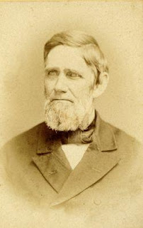
In the recent post about N. Dushane Cloward, it was noted that one of the business ventures he was associated with was the roller skating rink located next to Brandywine Springs Amusement Park. It was also mentioned that a fast-moving and briefly popular sport was played there, as well as at other rinks. I'm not sure quite why, but I thought I'd cover these topics here in their own post. Maybe it's because I don't get to do many sports-related posts, or maybe I just really miss hockey (NHL, not the KHL, OHL, or QMJHL stuff that's on now). In any case, the Country Roller Rink and roller polo do have their own stories, related to but separate from the amusement park.
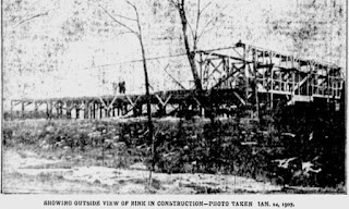
The roller rink was built 1907 and was always part of the park, but not really. It was officially owned by the Springs Amusement Company, a new entity managed by several of the amusement park managers, including Dushane Cloward. They sold stock in their new company to raise capital to build the rink, and anyone who purchased ten dollars or more in stock was entitled to free admission to the rink for the first year. [See follow-up post for more information.] One of those passes (seen below) is on display at the Red Clay Valley Visitor's Center Museum at Greenbank. It's about 4 1/2 inches long and is signed by N. Dushane Cloward, President of the company.
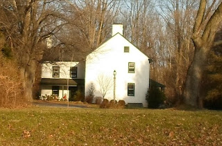
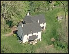
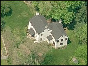
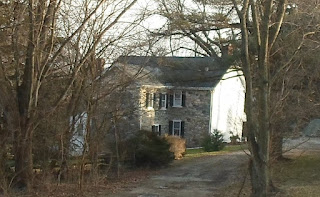
The rink was not built on park property, but was actually located on a lot in the Cedars, another venture owned by park managers. It sat at the end of Justice Ave., where a house stands today. The park and trolley line's power house was next to it, and for all practical purposes it was part of the amusement park. The rink building was 150' x 80' and was built on stilts, to keep the precious wooden floor away from the occasional floodwaters that Hyde Run still tosses around. It housed one of the largest electric organs in the east, and its 150' x 70' skating floor was said to be the largest one south of Philadelphia.
The rink had its official opening on April 27, 1907, when eight hundred people showed up, five hundred of whom skated. Just a few weeks later, guests were treated to the "Fancy, Graceful, and Trick Skating" of World Champion skater Eddie McDowell and his talented pupil, 12 year old Nellie McNeece. Although the primary use for the rink was, of course, skating, the owners got much more use out of their building, making it very much a multi-use facility. It was almost surely one of the larger indoor gathering spaces for sporting events outside of the city, and probably compared favorably to many within it. And unlike the amusement park, which was open more-or-less from Memorial Day until Labor Day, the Country Roller Rink was open year-round.
One of the more popular non-skating spectacles seen at the rink were the boxing matches. As a testament to its popularity, this article describes a bout on May 4, 1910 which was enjoyed by 3,000 spectators. They were, however, amateur bouts. In his book Brandywine Springs Amusement Park: Echoes of the Past 1886-1923, Mark Lawlor tells that just two months after this fight, rumors spread that a major promoter was looking to hold the next big prize fight at the rink, because it was the largest auditorium in the state. Manager Cloward, however, refused to allow professional fighting at his facility.
As thrilling as "The Sweet Science" was, for my money (and they probably would have gotten mine at the time) the most exciting sport contested at the Country Roller Rink was roller polo. This old Sports Illustrated article gives a good history of the game, but the short story of it is that it began in New England in the 1870's. Rich young guys bemoaned the end of polo season, and decided to take the new national craze of roller skating and combine the two into a new sport. What they came up with was roller polo -- essentially roller hockey. It was played by two five-man teams, consisting of a goalie, a first rush, second rush, center and a halfback. They played with a hard rubber ball about the size of a baseball, and used sticks similar to modern field hockey sticks. The sport was fast, rough, and not for the feint of heart.
The game began with the opposing first rushes racing from the goals to take possession of the ball, which was placed at the center of the rink. After that, the game was played very much like ice hockey, except with four twelve minute periods, plus a sudden death period if needed. The players wore leather leggings with rattan sticks in them for protection, with the goalies wearing baseball-style chest protectors and masks.
Roller polo was first introduced to the area at the Eleventh Street Rink in Wilmington, located on Eleventh near Madison. It was originally built in 1885 as a roller rink, but changed uses many times over its life. It was torn down in 1957, by which time it had been known for years as The Auditorium. Dushane Cloward was one of the early promoters of roller polo locally, and he quickly formed a team at "The Springs". Joined by two Wilmington teams -- Lenox and the Mohawks -- the Brandywine Springs club competed in a three-team local league, which seems to have been very competitive. A championship trophy was donated by the Springs Amusement Company. This retrospective account from 1941 gives a good feel for what the sport was like in its day.
It seems the league only survived for two seasons, beginning in the fall of 1907 and ending in the spring of 1909. During this run, Dushane Cloward became the lessee and manager of the Eleventh Street Rink, until it closed and became a laundromat later in 1909. Dushane was not the only Cloward bitten by the roller polo bug, though. The star player on the Springs team, and possibly the best player in the league, was Cloward's son Bill, who played first rush (an offensive position). The caption to the photo above states that he is the one seated in the center of the front row (although he seems to have goalie leg pads on).
Although roller polo waned in popularity locally over a century ago, it didn't disappear altogether. It's actually still around (now called roller hockey) and is popular, of all places, in Latin America. After the demise of the roller polo league, the Country Roller Rink carried on. By 1911, the rink was owned by the J .G. Justis Company, a lumber and hardware firm in Newport (they would sell to the E.J. Hollingsworth Co. in 1922). It's possible that after the death of N. Dushane Cloward in November 1910, the Springs Amusement Company was disbanded and sold the rink to Justis. If so, it was bad timing for the Newport company.
On the afternoon of July 24, 1911, just after a thunderstorm had rolled through, someone noticed flames coming from the end of the rink. The park's own fire brigade (formed after several previous fires in the park) began fighting the blaze, and two companies from Wilmington were called. Although the Water Witch company arrived very quickly, the rink was already engulfed in flames. As soon as the wooden stilts on which the rink was built burned, the whole building collapsed and was destroyed. Attention then went to the power house next door, which was ultimately saved with minimal damage. The rink, the organ, and the equipment inside were all a total loss.
But as with other buildings in the park destroyed by fires in the past, the rink was soon replaced, but it only operated for another couple years. It appears that the second rink not only was not just a rebuilt version of the first, it wasn't even a new building. This article detailing the demise of the rink states that it was actually a portion of a building from an exhibit located at City Hall in Philadelphia. It was a good bit smaller than the first rink, measuring only about 80' x 60'. It was this second, smaller structure that by 1913 was owned by William McCool (an assistant park manager), who may have taken over after the 1911 conflagration. Unfortunately for McCool, his rink would suffer the same fate as the first.
On the evening of September 12, 1914, while doing his usual rounds, park security guard John Connell heard a muffled explosion coming from the roller rink, and saw a man running away. He gave chase, but the shadowy figure escaped. As he returned to the rink, Connell saw flames shooting out, at which point he called Wilmington to have fire companies dispatched. But by the time help arrived, the rink was already destroyed. And unlike the previous fire, this time the powerhouse was also lost (by 1911, it was used only as a back-up). Residents of the Cedars spent the rest of the night dousing their roofs with water, desperately trying to save their homes. Luckily, with the exception of a chicken house in the backyard of the nearest home, nothing else was seriously damaged.
As it turned out, this marked the end of the Country Roller Rink. Unlike after the 1911 blaze, this time the rink was never rebuilt. Roller skating was briefly housed in the dance pavilion on the lake several years later, but there was never again a dedicated rink at the park. To the best of my knowledge, the lot on which the rink sat remained empty until the mid 1990's, when a house was finally built there. By that time, the Country Roller Rink and the roller polo played there had long since vanished from the memories of almost everyone.
Update 12/26/12: See this update post for more information gathered after the publishing of the original post above. Some information has been revised here, but more details and some additional pictures can be found in the update post.
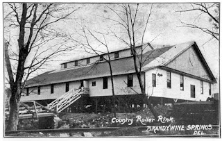
The roller rink was built 1907 and was always part of the park, but not really. It was officially owned by the Springs Amusement Company, a new entity managed by several of the amusement park managers, including Dushane Cloward. They sold stock in their new company to raise capital to build the rink, and anyone who purchased ten dollars or more in stock was entitled to free admission to the rink for the first year. [See follow-up post for more information.] One of those passes (seen below) is on display at the Red Clay Valley Visitor's Center Museum at Greenbank. It's about 4 1/2 inches long and is signed by N. Dushane Cloward, President of the company.

The rink was not built on park property, but was actually located on a lot in the Cedars, another venture owned by park managers. It sat at the end of Justice Ave., where a house stands today. The park and trolley line's power house was next to it, and for all practical purposes it was part of the amusement park. The rink building was 150' x 80' and was built on stilts, to keep the precious wooden floor away from the occasional floodwaters that Hyde Run still tosses around. It housed one of the largest electric organs in the east, and its 150' x 70' skating floor was said to be the largest one south of Philadelphia.
The rink had its official opening on April 27, 1907, when eight hundred people showed up, five hundred of whom skated. Just a few weeks later, guests were treated to the "Fancy, Graceful, and Trick Skating" of World Champion skater Eddie McDowell and his talented pupil, 12 year old Nellie McNeece. Although the primary use for the rink was, of course, skating, the owners got much more use out of their building, making it very much a multi-use facility. It was almost surely one of the larger indoor gathering spaces for sporting events outside of the city, and probably compared favorably to many within it. And unlike the amusement park, which was open more-or-less from Memorial Day until Labor Day, the Country Roller Rink was open year-round.
| Image may be NSFW. Clik here to view.  |
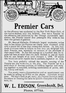
| From the Sunday Morning Star, May 12, 1907 |
As thrilling as "The Sweet Science" was, for my money (and they probably would have gotten mine at the time) the most exciting sport contested at the Country Roller Rink was roller polo. This old Sports Illustrated article gives a good history of the game, but the short story of it is that it began in New England in the 1870's. Rich young guys bemoaned the end of polo season, and decided to take the new national craze of roller skating and combine the two into a new sport. What they came up with was roller polo -- essentially roller hockey. It was played by two five-man teams, consisting of a goalie, a first rush, second rush, center and a halfback. They played with a hard rubber ball about the size of a baseball, and used sticks similar to modern field hockey sticks. The sport was fast, rough, and not for the feint of heart.
The game began with the opposing first rushes racing from the goals to take possession of the ball, which was placed at the center of the rink. After that, the game was played very much like ice hockey, except with four twelve minute periods, plus a sudden death period if needed. The players wore leather leggings with rattan sticks in them for protection, with the goalies wearing baseball-style chest protectors and masks.
Roller polo was first introduced to the area at the Eleventh Street Rink in Wilmington, located on Eleventh near Madison. It was originally built in 1885 as a roller rink, but changed uses many times over its life. It was torn down in 1957, by which time it had been known for years as The Auditorium. Dushane Cloward was one of the early promoters of roller polo locally, and he quickly formed a team at "The Springs". Joined by two Wilmington teams -- Lenox and the Mohawks -- the Brandywine Springs club competed in a three-team local league, which seems to have been very competitive. A championship trophy was donated by the Springs Amusement Company. This retrospective account from 1941 gives a good feel for what the sport was like in its day.
| Image may be NSFW. Clik here to view.  |
| 1908 State Champion Springs Roller Polo Team |
Although roller polo waned in popularity locally over a century ago, it didn't disappear altogether. It's actually still around (now called roller hockey) and is popular, of all places, in Latin America. After the demise of the roller polo league, the Country Roller Rink carried on. By 1911, the rink was owned by the J .G. Justis Company, a lumber and hardware firm in Newport (they would sell to the E.J. Hollingsworth Co. in 1922). It's possible that after the death of N. Dushane Cloward in November 1910, the Springs Amusement Company was disbanded and sold the rink to Justis. If so, it was bad timing for the Newport company.
On the afternoon of July 24, 1911, just after a thunderstorm had rolled through, someone noticed flames coming from the end of the rink. The park's own fire brigade (formed after several previous fires in the park) began fighting the blaze, and two companies from Wilmington were called. Although the Water Witch company arrived very quickly, the rink was already engulfed in flames. As soon as the wooden stilts on which the rink was built burned, the whole building collapsed and was destroyed. Attention then went to the power house next door, which was ultimately saved with minimal damage. The rink, the organ, and the equipment inside were all a total loss.
But as with other buildings in the park destroyed by fires in the past, the rink was soon replaced, but it only operated for another couple years. It appears that the second rink not only was not just a rebuilt version of the first, it wasn't even a new building. This article detailing the demise of the rink states that it was actually a portion of a building from an exhibit located at City Hall in Philadelphia. It was a good bit smaller than the first rink, measuring only about 80' x 60'. It was this second, smaller structure that by 1913 was owned by William McCool (an assistant park manager), who may have taken over after the 1911 conflagration. Unfortunately for McCool, his rink would suffer the same fate as the first.
On the evening of September 12, 1914, while doing his usual rounds, park security guard John Connell heard a muffled explosion coming from the roller rink, and saw a man running away. He gave chase, but the shadowy figure escaped. As he returned to the rink, Connell saw flames shooting out, at which point he called Wilmington to have fire companies dispatched. But by the time help arrived, the rink was already destroyed. And unlike the previous fire, this time the powerhouse was also lost (by 1911, it was used only as a back-up). Residents of the Cedars spent the rest of the night dousing their roofs with water, desperately trying to save their homes. Luckily, with the exception of a chicken house in the backyard of the nearest home, nothing else was seriously damaged.
As it turned out, this marked the end of the Country Roller Rink. Unlike after the 1911 blaze, this time the rink was never rebuilt. Roller skating was briefly housed in the dance pavilion on the lake several years later, but there was never again a dedicated rink at the park. To the best of my knowledge, the lot on which the rink sat remained empty until the mid 1990's, when a house was finally built there. By that time, the Country Roller Rink and the roller polo played there had long since vanished from the memories of almost everyone.
Update 12/26/12: See this update post for more information gathered after the publishing of the original post above. Some information has been revised here, but more details and some additional pictures can be found in the update post.