Quantcast
Channel: The Mill Creek Hundred History Blog
Viewing all 332 articles
Browse latest View live

Red Clay Creek Corridor Park and Greenbank Park Plan -- 1975

$
0
0
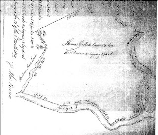
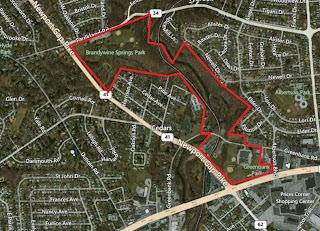
General outline of the Red Clay Creek Corridor Park area
In the mid-1970's, New Castle County found itself in possession of two properties in a state of flux, and it had to decide exactly what to do with them. One property -- Brandywine Springs Park -- had recently been acquired from the state, and the county was still trying to figure out what to do with it. The other property -- Greenbank Park -- had been the site of the County Workhouse (prison), which had just recently been torn down. The site was to become a county park, but what kind of park was still very much up in the air. As we all know, what ultimately happened to these sites was that Brandywine Springs stayed as a low-key, wooded park with a few ball fields and picnic pavilions, while Greenbank became an open sports-oriented space with ball fields and tennis, handball, and basketball courts.

Unknown to most (or at least until recently, to me), there was at least one other potential plan floating around during those high-flying Ford Years. I have no idea how seriously this plan was taken, or whether it ever had any real chance of being implemented. My gut feeling is that this was strictly a "Let's see what we can come up with on the ambitious end of things" kind of plan, and I have a hard time imagining it being adopted. And even if it had somehow miraculously been adopted, the continuous funding and effort it would have entailed would have made it an easy target any time budgets needed to be trimmed. Even with the strongest of supporters, I couldn't see most of the plan lasting very long.

So what are we talking about here, exactly? I've uploaded the plan here, so if you're interested go take a look. It's not as long as it first seems, and it's not hard to read. It doesn't get too technical or infrastructury, outside of a few mentions of water and sewer hook-ups. The plan is really more of a general concept of how to link the parks, along with a few properties in between (although it does give a list of costs at the end). Good luck trying to imagine what the area would be like with this Red Clay Creek Corridor in place! I do know that as a young child at that time, I think I would have loved it.

Rather than trying to properly recount and analyze the plan, I'm just going to bullet-point some of the main features and let you read and fill in the blanks. I do really wish there had been drawings of what they had in mind, though.

  • Mulched pathways would connect Greenbank and Brandywine Springs along Red Clay Creek, passing through the Greenbank Mill property.
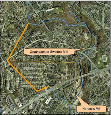
  • Albertson Park would be included. Albertson Park is essentially land north of Greenbank along the east side of Red Clay. The Kiamensi Spring Water Company site would be cleared and developed as "a point of interest".
  • A motorized tram would run between Greenbank and Brandywine Springs along paved paths to be built. The tram would be "the trackless type consisting of a motorized power unit and several coaches." I'm picturing something like an over-sized golf cart pulling cars, like you'd see as a parking lot shuttle at amusement parks (at least they used to have things like that -- I haven't been to a park in while).
  • I don't think it states when or how frequently the tram would operate. I would imagine only in spring/summer/fall, and/or only on weekends.
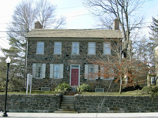
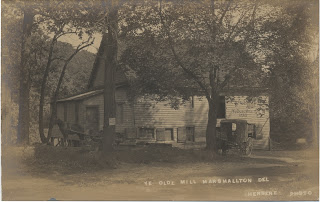
  • Greenbank Mill, which was still in a poor state at the time (only a few years after the devastating fire), was to be renovated and restored, along with its accompanying water system. The mill was owned by Historic Red Clay Valley, Inc. (also operators of the Wilmington & Western) at the time, and I can't quite tell whether the county would be purchasing the mill, or granting money to HRCV to do the restoration as a partnership. The area around the mill was to be developed as a pedestrian plaza and tramway drop-off point, highlighting its historic aspects.
  • The northern terminus of the tramway would be Brandywine Springs Park, which would see its highest level of action and construction since the early 20th Century. The tram would drop off at the area near the chalybeate spring (the Spring Garden), before looping around the to-be-restored lake and heading back to Greenbank. (Incidentally, the Friends of Brandywine Springs (FOBS) has been working for about a decade and a half to get the lake restored, and still the county has not gotten it right.)
  • A children's amusement area was to be built across Hyde Run from the Spring Garden. "The proposed amusement devices will reflect the early 1900's era. The rides are to include a carousel, swings, ferris wheel and devices." On the one hand, elementary school-aged Scott would have LOVED this. Grown-up "historian" Scott shudders to think what archeology would have been lost, since this would have sat right along where the old boardwalk ran during the amusement park era.
  • I don't know if this plan got as far as public debate, but if it had I think it could have gotten ugly. When FOBS was formed in the early 1990's, some residents in the Cedars loudly raised objections to any plans of "rebuilding" the amusement park, which is practically (and sometimes literally) in their backyard. Nevermind the fact that FOBS never had any desire to do such a thing, nor ever even raised the subject. Now after reading this report, I wonder if this is where those objections originated.
  • The upper part of Brandywine Springs would have been relatively unchanged, with just some more parking, another pavilion, and some enhanced trails and historic markers.
  • Greenbank Park would have seen several large changes from what actually occurred. Naturally, the tramway would connect the different sections of the park.
  • One section would contain an Activity Center, which would have space "for meetings, recreation, cultural arts and sales, rest rooms, maintenance, and for other suitable purposes." It was to be housed in an existing building, but I'm not sure what building that was.
  • A mall and entry plaza would provide a focal and gathering point for the park, and serve as the tramway terminal.
  • Greenbank Park would be home to a 5645 sq. ft. "Z"-shaped swimming pool. A pool building would house changing areas, ticket office, rest rooms, and maintenance and mechanical rooms.
  • A playground would be next to the children's wading pool, and would contain "a timber climbing device." Sounds like the playground equipment that used to be at Brandywine Springs.
  • Much of the rest of the park would have been developed similarly to how it eventually was. It was to have tennis courts, basketball courts, and handball courts. There would have been one baseball field instead of two.
  • There was to be a display and courtyard around the watchtower.
  • In the lower section of the park, the little league field would remain and the Wilmington & Western station area would be upgraded. Here also would be additional parking for the WWRR, the Greenbank Mill area, general park visitors, and the amphitheater.
  • Finally, an open-air amphitheater would be built on the north side of Greenbank Road in the open area below the brick "Warden's House".
Pretty extensive and ambitious, huh? The plan would have called for the county's acquiring 26.5 acres of private land, and the preliminary cost estimates were $1,142,050 for the Corridor Park and $1,995,158 for Greenbank Park. That was a total of $3,137,208. In today's dollars it would be almost $13.5 million, just adjusting for inflation. Of course, outside of the athletic facilities at Greenbank none of this ever actually was done. I don't know if this was ever a serious plan or just someone's pipe dream, but either way I still think it's fascinating to read and try to imagine. So give it a shot. I'll meet you and the kids at the amusement rides, we can take the tram back to the pool for a dip, then catch a show at the amphitheater. Sounds like a good time!

Jabez Banks Invitations

$
0
0
Jabez Banks, Jr.
In the recent post about the Mendenhall Mob I wrote about how nice it is to occasionally get a glimpse into the everyday lives of the 19th Century residents of Mill Creek Hundred, and how helpful it can be to come across something from their lives with which we can easily relate. Assuming that everyone has at one time received a party invitation, I have another example. A few months back I was given an envelope containing items relating to three events, all of which once belonged to an ancestor of the donor. There are two party invitations and one commencement program and ticket, all once belonging to a MCH native named Jabez Banks (1855-1927).

If the name sounds vaguely familiar, Jabez was mentioned briefly in the post about his brother, the local automotive pioneer Richard Banks. He was the son of Jabez and Jane Banks, English immigrants who settled originally in Christiana Hundred in the 1840's. In 1850 they were living in the area just west of Wilmington, near Dupont Road and Maryland Avenue (Rt. 4). Interestingly, this was very close to another newly-arrived English family, the Browns. By 1860, Jabez and Jane had moved to the same area in which several of the Brown sons also settled -- just west of Stanton.

Frustratingly, the Bankses never appear on any of the maps, even though their holdings in 1870 were as much as twice as great as some of their neighbors who were shown on the 1868 map. My hunch is that Jabez, Sr. first leased a farm from Joseph Wollaston near what is now All Saint's Cemetery, then bought a farm outright in the same general vicinity. One of two things probably happened -- either they were just missed by the mapmakers, or their timing was bad. Jabez could have bought his farm between 1868 and 1870. He died in 1880, so the 1881 map may have omitted the family because they sold their farm, or maybe because ownership was unclear and leaving them off was easier. I don't know. Either way it's frustrating.

Front and inside of program (top and middle) and ticket (bottom)

But now on to the items at hand. The first of the three events was the Commencement for the Boys High School in Wilmington on June 28, 1877. The high school had only been created earlier that decade, and was housed in the No.1 School located on French Street between 5th and 6th (probably about where the courthouse parking garage is now). The 1877 Commencement represented the school's third graduating class, and was held at the Masonic Temple, more commonly known today as the Grand Opera House. It had only been opened for a few years at that point, too.

Since there's no list of the graduating class, I'm not completely sure that Jabez was the one participating, but since the items came from a granddaughter of his I think that's the most likely scenario. The envelope has written on it "Mr. Jabez Banks", presumably for Jabez, Jr. But since he was actually 21 at the time, the possibility exists that the envelope was for his father, and that the graduate was Richard Banks, who would have been 17. Since school attendance was a bit looser then, either is possible. I still think that the commencement was for Jabez, though.


The second item (chronologically) is the party invitation seen above. It's for a "Social Hop" on Thursday, January 26, 1882, at the home of James K. Lynam. Lynam was obviously a friend of Jabez Banks, since at the bottom you can see that Jabez, along with Robson Banks (presumably his brother Richard R.), James' brother Quimby Lynam, and Gus Columbus comprise the "Committee". Since no Columbuses are listed in Delaware in the 1880 Census, I don't know who this final man was, planning the party with the Lynam and Banks brothers.

I was able, however, to figure out where the "Social Hop" took place. Unfortunately, James K. Lynam's house no longer stands, and in fact I doubt you'd even think that there was a house and farm at the site. As the invitation states, it was located near Christiana in White Clay Creek Hundred. More specifically, Lynam's property was just south of where the Christiana Mall is now, to the east of Route 1. You know how you sort of go through a wooded area on Route 1 between the mall and Route 273? Lynam's farm was in what's now that overgrown area, to your left if you're going south, to your right coming north. Although the area was farmed well into the 20th Century, James K. Lynam sold his farm in 1889 and moved away.


Almost three years later, it was apparently the Banks family's turn to play the part of party host. On Thursday evening, November 27, 1884, an "Evening Party" was held at the home of J. W. Banks. Of the three items, this one has by far been the most confusing and frustrating to research. Initially, I assumed that the party was held at the home of Jabez Banks, since the other items pertained to him and came from his family. Since the invitation states the gathering is "At the house of J. W. Banks, Riverside", I assumed that "Riverside" was the name of the Jabez's farm. But as was noted earlier, none of the Bankses ever appear on any maps, so I'm not completely sure where they lived at any given time. I know they were generally in the area west of Stanton, and the donor of the items said the family lived at one time in the old white house in the middle of the White Clay Creek Country Club (Delaware Park) golf course. I thought since it's near the creek, maybe they sort of tongue-in-cheekily called it Riverside.

Eventually, though, it occurred to me that I didn't know what Jabez's middle initial was, and I had never seen him called "J. W.". I soon realized that the party host was not Jabez, but rather his older brother John W. Banks (1852-1931). The next step was to try to figure out where John was living in 1884, and what or where Riverside was. Censuses are not much help, since it's more than four years after the 1880, and 16 years before 1900, the next available census. In 1880 John was living in New Castle Hundred in the vicinity of the 13-40 split, probably near School Bell Road. Since nothing about that area screams "Riverside", I kept looking.

I couldn't find much, but I did run across one item that I think gives at least the general location of the party. This report dealing with cattle health lists in its survey a J.W. Banks, Riverside. He was visited less than two months after the party, and his position directly after the Edgemoor Iron Company is the vital clue. At that time, the PW&B Railroad station just north of Edgemoor in Brandywine Hundred was called "Riverside". Assuming that the area around was also referred to as Riverside, this puts John W. Banks' house somewhere in the vicinity of Bellefonte or Gordon Heights. I don't know precisely where he lived, but if I ever find out I'll be sure to update.

One last note on the Banks party invitation has to do with a word conspicuously absent from it. Did anything about the date stand out to you? I even went back to verify it, and yes, Thursday November 27, 1884 was the date of Thanksgiving that year. It's possible that John's party was in part a Thanksgiving party, but I think it goes to show how differently the holiday was thought of then. Could you imagine someone today, A) throwing a party on the night of Thanksgiving, and B) not even mentioning the word Thanksgiving on the invitation if they did?
Jabez and Sarah Banks, daughters Jessie, Bessie, and Annie (Nan)

This all leaves me, in the end, wondering why Jabez Banks saved these these items through the years and several moves. The following is purely romantic speculation, but I have some ideas. The high school commencement items he probably saved just because he was proud of having graduated, something still not common at the time. Jabez and Sara (Chambers) were married in 1883, only a year after the Lynam Social Hop. I wonder if this had some significance to them -- maybe they met at the party, or perhaps announced their engagement there. Their first child, daughter Jessie, was born in July 1884, only four months before the J.W. Banks party. Was this the first time they got to show their new baby off to their friends? Again, all speculation, but fun try when dealing with emotions and feeling we can directly relate to.

The Isaac Flinn House

$
0
0
There was a picture I had seen a while back (shown at right) that had piqued my interest, but I hadn't gotten around to writing about it until now. The only clue to go on in the quest to figure out where it might have been was the caption attached to the picture, which reads -- "Isaac Flinn House, Price's Corner, Wilmington, Delaware, 1890's. Isaac Flinn and his family pose inside the gates in front of their home. The house had served as an inn about the time of the American Revolution." Obviously, the mention of Price's Corner caught my eye, and while that meant it was probably a bit outside of MCH, it was close enough to interest me.

Since the house didn't look like anything I recognized as standing today anywhere near Price's Corner, the only clue to go on was the name "Isaac Flinn".  The Flinn family has been in the region for quite a while, and was prominent in the 19th Century in a broad swath from Newport to Greenbank. The name shows up all over the 19th Century maps, but sorting out the family is a bit tricky since there doesn't seem to be a good, comprehensive genealogy of the clan.

Many questions came to mind in thinking about the picture, but three stood out to me -- 1) Who was Isaac Flinn? 2) Where was the house? and 3) If it was used as an inn in the late Colonial Era, who might have owned and operated it? As usually is the case, some questions were easier to answer than others. The first thing I wanted to know was who Isaac Flinn was, since the answer to that would probably also give me the location of the house. Finding him was slightly confusing at first, but then relatively simple. However (as also usually is the case), the answer raised other questions.

At first I though the man in the photo might have been the same man mentioned in the post about the Cox-Mitchell House. I soon figured out that he wasn't, but the Isaac W. Flinn who moved to Hockessin might have been an uncle of the Isaac in our picture (again, my grasp of the family is thin in places). The Isaac we're looking for -- who would have been living near Price's Corner about 1900 -- is Isaac J. Flinn, born in 1851 to John J. (1818-1894) and Ellen Flinn. It's this connection to John Flinn that gives us the location of the house in the photo (as best as I can figure). John Flinn is shown on all the maps (1849-1893), and couldn't be more in "Price's Corner". In fact, he lived on the adjacent property to David Price, namesake of the area.

1849
1868
1881


The above maps show the location of John J. Flinn's house, on the northwest corner of present-day Old Capital Trail and Centerville Road. As you can see on the later maps, Flinn acquired a number of surrounding properties, some of which may have been used by his sons. Since the 1849 map shows only the one, I think it's safe to assume that this was his original home. To get even a bit more specific as to the exact location, old aerial photos seem to place it right about where the Wells Fargo (formerly Delaware Trust) bank is now.

If you recall, I mentioned earlier that Isaac's identity raised some questions of its own. The question is, if that is Isaac in the picture, who are the other people? Isaac Flinn was a life-long bachelor. The 1880 Census lists Isaac in his father's household, and Thomas Flinn (Isaac's older brother) directly before them, so Thomas probably resided in one of the other properties his father owned. The 1890 Census is lost, but 1900 (the first after the passing of John J. Flinn) has Isaac again listed directly after Thomas, who was married with 2 children (including son Darlington, who would inherit the properties). So it is possible that younger son Isaac took over father John's home, since Thomas was already in a home of his own.

But since Isaac was single, who is in the picture? We have to assume the man in the hat is Isaac. It's a bit hard to see, but to my eyes it looks like two older women (on the front porch and in the rear) and a younger woman between them. My guess from their placements is that the woman on the porch is Thomas' wife Anna, the younger woman is their daughter Sarah, and the woman in the rear is Isaac's servant Marian Lynam. Why Thomas is not there I don't know. Perhaps he was busy, and the photographer had them get Anna and Sarah to make it more of a family picture. Since all we have to go on is the caption (which may have even been added later), we may never know.

The final question I wanted to answer is by far the most difficult one for which to do so. That is, if the house truly was used as an inn during the time of the Revolution, who ran it? The short answer is, I don't know. [And I should mention that the reason I don't sound 100% convinced that it really was an inn is that the only evidence (that I've found so far) comes from this one photo caption, made by a photographer who was going around taking pictures in the 1890's. He was probably told the story by the family, and we all know how family stories can get exaggerated over time.] All I can do for now is surmise that one of two possibilities must be true -- either it was owned by an ancestor of Isaac's, or it wasn't. (Brilliant, huh?) If it was not a Flinn who owned it in the 1770's then I currently have no leads on who else it might have been.

If we make the assumption, however, that this house had stayed in the Flinn family for a few generations going back, then I do at least think I have a guess. John J. Flinn's father was also named Isaac, and he died in 1844, early enough for John to have inherited the house and be listed on the 1849 map. This Isaac is still probably a bit too young to be who we're looking for, and I'm having a hard time finding good information about the family back that far. However, Scharf provides us with a list of taxables for Christiana Hundred (in which the Price's Corner area sits) for 1787, and on that list is one Flinn -- confusingly but not surprisingly, John Flinn. My guess is that this is the elder Isaac's father, and grandfather of John J. Flinn. So if this house was used as an inn around the time of the Revolution, and if it was in the Flinn family then, the owner at the time may have been this John. Until better information comes along, that's my best guess.

As you can see, not only is a picture worth a thousand words, sometimes it's worth as many questions.

The David Wilson House

$
0
0
A short while back I made mention of the fact that for the foreseeable future I'd be having less time to research and write the blog. I also mentioned the possibility of "Guest Posts", if anyone had anything they knew about or were researching, and felt like sharing. After all, that's how this blog started -- I was doing my own research for fun and decided to find a way to share what I'd found with anyone who might be interested.

I'm happy to say that I've already received several responses, and this post represents the first such Guest Post on the MCH History Blog. It was written by Dave Olsen, who often runs across lost history, off the beaten path (literally). He's the one who showed me the Plumgrove Farm ruins last year. Here's what he came up with:


The David Wilson House
While running earlier this past winter, I happened to turn off of Brackenville Road into HockessinValleyFalls.  As I headed around the outside loop of the neighborhood, which by the way gave me a great view of the valley looking towards Lantana Square, HAC and obviously Valley Road, I literally ran right back into the 1700’s and a complete farm that has changed little in the past 250+ years.  After pinching myself to make sure I hadn’t entered some time warp, I couldn’t get home quick enough to start looking into the details.  A return trip by car confirmed my initial reaction.  There are two lots:  506 and 516 Wilson Drive.

The site itself is really quite remarkable, and the fact that it remains even though it is surrounded by an upscale neighborhood makes it even more unique.  The farmhouse, with its many additions and upgrades over the years (logs, stone, stucco and framing) is still in excellent condition and is by all appearances still very much inhabited.  In addition, there are a number of out buildings and other structures that still survive.  The ruins of a substantial barn and silo are also there with the dairy cow milking pens still located in a portion of the barn.   It really gives one a great understanding of how many of the farms that make up our area were probably situated.  With a little MCH inspired research here is what I found.
 
Wilson Family holdings, 1868
 
On the north side of Wilson Drive is the complete homestead and farm of David Wilson which is clearly indicated in both the 1849 and 1868 maps.  I immediately searched your MCH blog and did not find any entries or references (didn’t want to duplicate your efforts).  The next step was to check in with my trusty Joseph Lake’s Hockessin History book and on page 24 through 26 the story of the Wilsons of Hockessin is detailed quite nicely.  It appears that the Wilsons have been a part of our community as far back as 1718.  All of the information that follows is directly from those pages.

According to Mr. Lake, the first of the Wilson clan was Christopher who was born in Yorkshire, England in 1690.  He immigrated to New Castle as an indentured servant and after serving his indenture married Ester Woodward of MCH in 1719.  For the next 21 years, Chris was a significant influence in our area helping to found the Hockessin Friends Meeting and becoming a minister in the society in 1728 and farming the current acreage.  He died in 1740 at which time the farmstead was inherited by his son James who continued to successfully farm, not to mention, upgraded the family cabin with a stone house around 1741.  He also significantly expanded the family holdings with the acquisition of several large farming parcels.
 
Aerial view of the Wilson Farm
 
In 1762, James’ son Stephen was born on the farm and he continued in the footsteps of his father and grandfather.  Of the six children he fathered through two marriages, the eldest, David was born in 1795 and inherited the farm upon Stephen’s death in 1823.  David improved and enlarged the current house around 1853, and furthered added to the family holdings as indicated on the 1868 map.  During the course of the next several decades, the Wilsonfamily continued to dominate the Valley’s landscape becoming the “unofficial” Hockessin land barons.  The farmstead was eventually divided and sold in the mid 1980’s to developers and the neighborhoods of Hockessin Greene and HockessinValleyFalls were born.


Some Thoughts About the Scots-Irish in Mill Creek Hundred

$
0
0
This is really less a full-blown post than just a few thoughts, but I wanted to put them out there while they were still rattling around in my head. I've seen several programs recently that dealt in various ways with the Scots-Irish, and it got me thinking about something. I'll get to it in a moment, but first a quick refresher on the Scots-Irish (sometimes Scotch-Irish) and their importance to MCH and to the country.

The Scots-Irish were Scottish Protestants (primarily Presbyterians) who were forced by King James I (himself a Scotsman) to settle in the newly-conquered Catholic lands of Northern Ireland, in the region of Ulster, in the early 1600's. Over the next century, these Presbyterian Scots endured numerous hardships and persecutions, many caused by the fluctuating leanings of the English crown regarding their preferred religious strain. By the early 18th Century, many of these Scots-Irish families had decided they'd had enough, and set off west in the hope of finding greater freedom in the English colonies of America. As it happened, many of these immigrants entered the New World in our region, coming through Philadelphia and New Castle. And while their treatment in the Old World explains why they emigrated, it's the treatment the Scots-Irish received in the New World that I'm particularly concerned with now.

As luck would have it, when the Scots-Irish arrived in America, the reception they got was not much better than it was back home. The English colonists already here looked down on them as dirty, profane, uneducated country-folk, and seemed to want to have little to do with them. It sounds not much different than the attitude towards the Irish immigrants in the 19th Century. For that reason, and because these Scots-Irish were used to living in the wildernesses (such as they were over there) of Scotland and Ireland, many of them pushed south and west, away from the English-populated areas near the Atlantic seaboard. Large numbers of them eventually settled in the region of Appalachia, which was the western frontier at the time. Their Scots-Irish culture became the foundation of the Appalachian culture (no, not an oxymoron), and by extension much of Southern culture in general. Even such prototypical Southern words as "redneck", "hillbilly", and the most Southern of them all, "y'all", may have their roots in the Highlands of Scotland.

The treatment given the Scots-Irish by the English had one other major implication, too. Because of their history, when the Revolution began in 1775 the Scots-Irish became some of the fiercest backers of the rebel cause. Their frontier skills were especially useful in some of the western campaigns. To show what an impact they had, one Hessian captain wrote, "Call it not an American rebellion, it is nothing more than an Irish-Scotch Presbyterian rebellion."

Not all the Scots-Irish of the early 1700's left for the hills of Kentucky and Tennessee, of course. A fair number settled here, in Mill Creek Hundred. Along with the Quakers, the Scots-Irish Presbyterians were truly the founders of MCH (with a few Swedes and Fins, of course). The early Presbyterian congregations on either end of the hundred -- Red Clay and White Clay Creek churches -- were both founded by Scots-Irish immigrants.

All of these facts had been known to me for a couple years now, but only recently did one aspect of the story get me thinking about something (see? told you I'd get to it). With all of maltreatment and bigotry that the Scots-Irish apparently suffered at the hands of the other English colonists in other places, I realized that I have never come across any accounts of confrontations or other problems here in MCH or surrounding areas. Now, of course there could have been some issues that just weren't great enough to make it into the historical record 300 years down the road, but I assume there weren't many, just judging by the size of the Scots-Irish communities that did settle down here. From everything I've gathered, the Scots-Irish Presbyterians in early MCH lived peacefully alongside their English neighbors. Assuming this were true, why was this the case here, when it obviously wasn't in many other places?

I really don't have an answer for this, but I do have a few ideas (surprise, surprise). My first thought is that the rough-and-tumble Scots-Irish found tolerant neighbors in the Quakers, who may have been less likely to mistreat them. The lingering Swedish and Finnish families would also have had less of a cultural reason to look down at them.

My second thought is that their settling in MCH may have been less of an exception to the rule than it seems. This area 300 years ago was still sparsely settled, with large tracts of land still available from the Penn family. And while MCH wasn't exactly "The Frontier", it still may have been a place to get away from some of the more populated areas elsewhere.

Unfortunately, I really don't know enough at this point to test any of these theories, or to know if there's any mystery at all as to the presence of the Scots-Irish communities here. Maybe these aren't really out of line with Scots-Irish numbers elsewhere, or maybe it was just random chance that they settled here. One thing's certain, though -- the Scots-Irish are an often-overlooked group that was vital to the formation of Mill Creek Hundred and to the United States.

A Different Direction on Smith's Corner

$
0
0
If you'll recall (or even if you won't), a while back there was a post that included a 1921 picture of a bridge that was captioned as being "near Smith's Corner". Since the picture looked to me to be almost certainly taken on Old Capitol Trail just west of Newport Gap Pike, I spent a considerable amount of time trying to figure out just what and where Smith's Corner was.

At the time, my working assumption was that Smith's Corner was the Newport Gap Pike-Old Capitol Trail intersection that would have been just behind the photographer of the 1921 shot. I and several others then went about trying to figure out why it was called Smith's Corner, a name no one seems to have been familiar with. I spent my effort attempting to find someone named Smith who ever lived at or near the crossroads there. Seemed like the logical answer at the time. A follow-up post even put forth one possible theory for the name.

Since then I've had a thought. OK, actually I've had lots of thoughts, but this isn't about me braggin' on my thinkin'. Specifically, I wonder if I was going about this the wrong way, and the answer was staring us in the face the whole time. If I asked you to name this area now, quite likely you'd say Price's Corner, right? Well, Price's Corner, a name that's been in use since at least the early 1900's, was named after David Price (1811-1892), a long-time landowner on Old Capitol Trail. Price's property was located right about where the Kirkwood Highway-141 interchange is now. Then, it was at the center of the junction of Old Capitol Trail (or Lincoln Highway, as it was previously known), Centerville Road, and Greenbank Road.

David M. Price's property, 1868
What connects Price to the story of Smith's Corner is his occupation, which some of you might know already, and which others might be able to figure out from the above map segment. David Price was a blacksmith. When I finally put this fact together with the idea of Smith's Corner, I started wondering -- Could the Smith being referred to be an occupation, and not a proper name? Might Smith's Corner mean the junction at the smithy, not one near a guy named Smith?

The one problem I'm still having with all of this is that I've still not found another reference to the name of Smith's Corner here. The earliest mention I've found for Price's Corner was 1901, and it was surely in common use by 1903. Since this is long before the 1921 date of the bridge picture, I'm still not sure why it wasn't used as the description for the location then.

The Price/blacksmith connection is just one more theory for the origin of Smith's Corner, and might be just as wrong as any of the others. The answer still could be that Smith's Corner was the intersection of Newport Gap and Old Capitol Trail. What we really need is a corroboration of the Smith's Corner name, to be sure it was a real thing and not just something the State Highway guy wrote on his photo for no good reason. Until then, it's just fun speculation.

National Guard Encampments at Brandywine Springs

$
0
0

Richard R. Kenney

Perhaps no place in Mill Creek Hundred has as rich and diverse of a history as Brandywine Springs. Normally when we think of these 60-some acres at Faulkland Road and Newport Gap Pike we think of its more than two centuries worth of use as a public site for rest, relaxation, and entertainment. The site has, in turn, hosted a colonial-era tavern/inn, a resort hotel, an amusement park, and a public state/county park. Lesser known are some darker stories, including several deaths and at least one tragic murder. But just as interesting and noteworthy as these chapters are the park's military connections, including one Victorian Era story in particular. (Hat tip to Terry Zitzelberger for making me aware of it)

Throughout its history, MCH has had occasional brushes with the military, whether it be Robert Kirkwood, the events of early September 1777, or the more recent presence in or near the hundred of several facilities used by the armed forces, reserves, or National Guard. It happens to be this last group that takes center stage in this story, which takes place at Brandywine Springs.

Probably unknown to most, Brandywine Springs does have several of its own military connections, including its very name. The hotel constructed in the 1820's was named "Brandywine Springs" in a blatant attempt to capitalize on the notoriety of the name "Brandywine", 50 years after the battle of the same name. An old story states Washington met with his generals here before the battle, although the veracity of the tale is open to question. Not open to question is the fact that the last use of the old hotel, before it burned in 1853, was as a military school. Less than a decade later, the fields on which we now play softball and football played host to the encampment of the 4th Delaware Regiment, prior to their marching off the help salvage the Union.

After the Civil War, as often happens in the aftermath of a difficult conflict, enthusiasm for things military began to wane. The populace, exhausted by four years of brutal, bloody strife, became disinterested in the military. Some of the recently discharged veterans, however, still longed for the camaraderie of army life, and several militia organizations sprang up. These were really more like fraternal organizations than military outfits, however, and most petered out after a few years. Only during the patriotic upswell of the Centennial in 1876 did the militia/guard movement truly grab a foothold. (A much better, more in depth history of all this is available here, by the way.)

Even though the patriotic fervor of '76, too, soon passed, these volunteer militia units were soon put to a new use -- suppressing the rising number of  incidents of civil unrest spurred by the labor movement of the post-war years. Militia units were used in a number of states as strikebreakers, sent to restore order during the often violent labor actions of the time. In Delaware, the late 1870's and early 1880's saw the formation of the modern National Guard here, under the leadership of Gen. James Park Postles. Under his guide, the various volunteer militia units became the cohesive National Guard of Delaware.

One of the new programs instituted by Gen. Postles (and his successor, Gen. Richard R. Kenney)  was a statewide summer encampment, first held in 1887. Two possible sites were chosen -- Brandywine Springs and Rehoboth. Although Rehoboth might sound like a good choice today, in 1887 it was no more than a small religious camp filled with mosquitoes and sand flies. Many of the officers and soldiers were less than thrilled about the seaside location, with one officer commenting, "If we go to Rehoboth we'll get nothing to eat but crabs and fish. We go to Rehoboth so that some investors can get some money out of it."

It seems that Rehoboth did turn out to be a poor decision, because after only one year in Sussex County the encampment was moved the following year by Gen. Kenney to Brandywine Springs. In 1888, the hotel and grounds were in their third year of operation by Richard Crook, but were not yet the full-blown amusement park they would be a few years later. The encampments of 1888 and 1889 seemed to have gone off quietly, a chance for guardsmen from across the state to gather, mingle, and drill. The week-long encampment of 1890, however, was a whole different story.

It got underway on Sunday, July 27, 1890, under the leadership of Brigadier General Kenney, with only a handful of minor incidents to report. (As reported here, in the July 28 issue of The Philadelphia Record.) The cadets from Delaware College (now the University of Delaware) were especially impressive to all, one of them even drawing his bayonet on Gen. Kenney when he failed to give the correct countersign while passing through the lines early Monday morning. Another similar incident took place when a Captain failed to give the countersign. As The Record reported, "After some parleying the sentry settled matters by throwing the Captain over a tent. The officer then withdrew." Since these incidents took place essentially in the middle of the night, one wonders where these officers were coming from.

These were not the only occasions of less than proper military conduct during the week. One night after taps, a large group of soldiers and civilians gathered around the artillery unit and began to "caterwaul". When one soldier yelled out the night's countersign (to answer the sentry if trying to enter the camp), an upset Gen. Kenney promptly changed the codeword. This caused mass confusion when numerous stragglers who hadn't heard the change wandered back into camp well into the early morning hours.

On another day -- a particularly hot and steamy one, as we know late July can be around here -- the camp's medical officer informed Gen. Kenney that the dress parade scheduled for 4 PM was an ill-advised idea. Word was never passed along, however, and the men were called into formation at 4. When Surgeon Marshall heard the call, he rode out onto the parade ground to dismiss the men, for which he was loudly applauded.

One evening during the week, two fifers were arrested for trying to pass a couple of women through the lines. I'm sure they were just attempting to educate the young ladies about the inner workings of the military lifestyle.

In addition to these incidents,  there were later charges from some of drunkenness and "wagons of whiskey". Others said the liquor came from local farmers looking to profit from the encampment. When you bear in mind that most of the men involved were not professional soldiers but simple farmers and laborers, all the accusations seem well within the realm of possibility.

The end result of the 1890 encampment was more than just some fun stories of a wild week at the Springs. There was real outrage and disgust at the goings-on there, and Episcopal Bishop Leighton Coleman (an influential personality in the region) even wrote about effects of the camp on the character of the young men present. It probably didn't help matters that Governor Benjamin T. Biggs was in attendance at the encampment, too. That same year of 1890, possibly partially due to the events at Brandywine Springs, the law authorizing (and more importantly, funding) the encampments was repealed. The state legislature apparently didn't think the $7,000-$9,000 pricetag was worth it any longer. The idea of the summer encampment would be revived early in the next century, no thanks to the events on the otherwise peaceful fields of Brandywine Springs in the summer of 1890.

Gettysburg Sesquicentennial

$
0
0

Pickett's Charge, July 3, 1863

I don't often do little timely posts like this, but this seemed too important not to acknowledge. As most of
you are probably aware, we are in the midst of the 150th anniversary of the Civil War. Today (June 3, 2013) happens to be the 150th anniversary of the final day of the three-day ordeal of the Battle of Gettysburg. I call attention to this sesquicentennial not just to be able to use the word sesquicentennial, which I happen to think is a pretty cool word. I don't want to write up a history of the battle, which many other much more qualified people have done. Suffice it to say, it was a pretty big deal.

We were more than two years into the war by that point. Confederate General Robert E. Lee decided that if he could only bring the war to the north, win a few battles and maybe take a city or two, the northern populace would grow as tired of the conflict as the southerners, who had already seen it up close, had. In June 1863 he moved his army up through western Maryland and into southern Pennsylvania, meeting the Union Army of Gen. George G. Meade (promoted three days earlier) near the small town of Gettysburg. The three day battle that ensued didn't end the war, but it did help to make clear that ultimately, the Union would prevail.

On July 1, 2, and 3, 1863, the once-quiet fields and hills around Gettysburg played host to the largest battle ever fought in the western hemisphere. More Americans fought and died here than in any other battle in history. Over 150,000 soldiers took part in the battle, and more than 30,000 were killed or wounded. The victory by the Union forces pushed the Confederates back into Maryland and Virginia, ending Gen. Lee's hopes of a successful Northern Campaign -- and ultimately his chances of winning the war.

I bring up this anniversary here for two reasons. First, I think it's an important moment to remember, and a good excuse to call to mind the unbelievable bravery and sacrifice of thousands of Americans. (Even those fighting to tear the country apart, but I'll try to keep this as a historical post, not a political one.) Secondly, there does seem to have been a small MCH story to tell, too. In his book Hockessin: A Pictorial History, Joseph Lake recounts an amazing fact. Several older MCH residents, years after the fact, stated that they could actually hear the battle as it was going on. From at least the areas around Hockessin and Little Baltimore, the low rumble of artillery could be heard in the western summer sky.

It wasn't specified which day or days they were referring to, but my best guess is that it would have been 150 years ago today, on the afternoon of July 3, 1863, around 3 PM. It was then that about 260 cannons, US and Rebel, fired upon each other in what may have been the largest artillery battle ever in the western hemisphere. This barrage preceded the famous (or infamous, depending on where you're from) Pickett's Charge, which ended disastrously for the boys in gray and sealed the Union victory. The deafening din of the artillery is known to have been heard in Harrisburg, which is not too much further away than northern MCH. It's entirely possible that Mill Creek Hundred residents heard the battle that afternoon, not knowing how many thousands were giving "the last full measure of devotion" so that our nation might live.

MCH History Blog On the Road: The Lea-Derickson House

$
0
0
Lea-Derickson House
Take a trip sometime into Wilmington and position yourself on the north end of the Market Street Bridge over the Brandywine. In the 18th and early 19th Centuries, this was the heart of Brandywine Village, and the engine that drove Wilmington’s early economic development. As you stand at 18th Street looking north, behind you were the mills that made Wilmington a force in the colonial economy. The “Wilmington Superfine” flour produced here was known worldwide, and was generally regarded as the best produced in America. From this trade, the men who produced the flour became very wealthy. These men, Quakers mostly, chose to build their homes very near the mills. There were a few on the south side where the first mills here were constructed, but most chose to build on the north side, and created what came to be known as Brandywine Village. Not a part of Wilmington until 1869, the village was simply an unincorporated part of Brandywine Hundred. It had no official political leadership, and any disputes were settled at the home of Squire Elliott, the Justice of the Peace. His house stood to your right, where the small park and historical sign are today.

However, for this post we shall turn our attention to our left, and the wonderful Lea-Derickson House at 1801 North Market Street. This five bay, fieldstone home was built in about 1770 by James Marshall (born abt 1735), who, along with his brother William (1735-1808), was attempting to bring milling to the north bank of the Brandywine. To this point, with the exception of one small bolting mill, all industry was along the south side of the river. The Marshalls had but one major obstacle to overcome - the rocky formations that made digging a race very difficult on this side. However, the excavated stone did make good building material, and this house, as well as the Joseph Tatnall House next door, was constructed from it. Unfortunately for the Marshall brothers, they had gotten themselves in over their heads. The north race proved to be more difficult a task than they could support, so they handed control of the project over to Joseph Tatnall, who in addition to being James Marshall’s brother-in-law, also had more money.

When James Marshall’s capital ran out, he was also forced to sell his home, which he did in 1772 to another miller named Samuel Morton. Morton held on to the property for several years, until he sold it to Thomas Lea (1759-1833). It is not known for sure when Lea bought the house but it may well have been in 1785, when he married Joseph Tatnall’s daughter Sarah. Joseph Tatnall was the leading miller and citizen in Brandywine Village, and soon brought his son-in-law into the family business with him. By 1801 Thomas Lea was a partner in his father-in-law’s mills, and built a second home a block to the north at 1901 Market Street. However, he held on to his first house until 1819, when a massive fire destroyed his largest nearby mill. Lea used the proceeds from the sale of the house to help rebuild his business. He would be quite successful at this, and the Leas would continue to dominate Brandywine milling until late into the 19th Century.

Brandywine Village, Lea-Derickson House
with ivy in the center, c.1905

Sometime in the mid 1830’s, the Lea's old house was bought by a millwright named Jacob Derickson (1781-1851), as a wedding gift for his daughter Martha. Her husband, Amor Hollingsworth Harvey, was an executive in a steam engine company, and would soon be a partner in what would be renamed Hollingsworth, Harvey, and Company. The firm manufactured boilers and steam engines, including locomotive engines. Harvey lived in the house until his death in 1887, when it was left to his daughter Sarah Derickson Harvey, who had married her cousin David P. Derickson (1828-1903).
The house in 1937, during the Bringhurst residency

In 1870 David and Sarah had a daughter named Martha, who in 1906 married a member of another prominent Wilmington family, the Bringhursts. Martha's husband, Frederick Bringhurst (1873-1955), was for many years the vice-president of the Wilmington Savings Fund Society (WSFS). Martha was also involved in the community, serving as president of the Wilmington New Century Club, a women's organization housed in what is now the Delaware Children's Theater on Delaware Avenue. (In case you wanted a MCH connection, here's a note of Martha speaking to the Marshallton Civics Club in 1927.) Martha Derickson Bringhurst resided in the house the remainder of her life, passing away in 1957.

During the occupancy of the last generation of Dericksons, it seems the history of the house was starting to slip away. This newspaper article from September 10, 1944 shows that at that point, Mrs. Derickson didn't even know exactly how old the house was. The photo above shows the house during the Bringhurts' tenure, complete with the front covering that had lead to it being called "Ivy Cottage" in Jacob Derickson's time.
A similar, more recent view of Brandywine Village

In the early 1960’s though, the future of the Lea-Derickson House, and all of Brandywine Village was in doubt. Developers were looking to build up the area, beginning with this stately home. Thankfully, a group of concerned citizens formed the non-profit corporation Old Brandywine Village, Inc. (O.B.V.). They bought the Lea-Derickson House for $60,000 in 1963 and began to renovate and restore the structure. The first step was to remove the thick growth of ivy from the front, and expose the beautiful simplicity of the native Brandywine granite. Next, later 19th and early 20th Century updates were replaced with Colonial and Federal period fixtures and ornaments. Finally, modern plumbing, heating, and electrical fixtures were added. O.B.V. then searched for a group to lease the house, which they found in the Junior League of Wilmington. The organization still occupies the site today. Thanks to the work of O.B.V., this beautiful piece of Wilmington's early past is still with us today.

Reminiscences of Stanton

$
0
0
The Old Stone, or Rising Son, Hotel, c.1970
I'm proud to present here the next in what I hope to be a continuing series of Mill Creek Hundred History Blog Guest Posts. Slightly different than the last one, this post is a collection of a few of one man's memories of Stanton. I was contacted a while back by Raymond Albanese, who currently resides in Conowingo, MD. But from 1962 to 1977, Raymond lived in Stanton, in Mannette Heights (between Stanton Middle School and the railroad tracks). He had some additional information about several earlier posts, and after some thought, we decided to roll them up together into one post. It's not meant to be a single narrative, but rather a collection of several separate thoughts on various topics relating to the Stanton area. I've added a few links to the original posts for reference.

Below is what Raymond sent me, with just some very minor editing to convert an email into a blog post. All the memories and stories are his, and we hope they'll spark a few of your own. As always here, please feel free to add your own thoughts and recollections. Odds are if you remember it after all these years, either someone else does too, or else they've been trying to remember it. Thanks again to Raymond for taking the time to write these up. Enjoy!


On one of your comments in reference to the Stone hotel in Stanton [post is here], where it was razed to build the Alert gas station, the question was asked if it was a doctors office at one time. Indeed it was. As I knew it in the early sixties it was a Dr. Carrol who practiced medicine there and lived there also with his wife and daughter. The daughter attended school with me at Stanton Jr. High. The house stood on the east side of Mill lane. It was razed in the late sixties or early seventies after the construction of Mitch Rd in 1969. Another part of little Delaware's history erased in the name of the inevitable thing called progress.

Across the street from Dr. Carrol's, on the northwest corner of Limestone and Main St., was a stone farmhouse next to St. Marks. As far as I know that house was occupied by the Naylor family, then the Poultneys, then the Goulds. They farmed that area where Stanton school is now. In 1962 I watched from the second floor of Stanton Jr. High as the house was demolished using an actual wrecking ball. I was scolded by my social studies teacher, Mr. George Glynn, for looking out the window. It's not everyday you see a wrecking ball in action. Across the street from there was the "famous" Stanton Arms. The only remnants of that establishment now, as I can see from the street, is a steel pole about three feet high bent into an L, still embedded in the sidewalk. That pole was the neon light sign bearing the name Schaefer beer.

The now-infamous bent pole from the former
Stanton Arms. I never noticed it before. Did you?

Another question in your comments was about the Bennett family on Telegraph Rd. and where it was located. [There are several related comments here.] The home was a white structure, still there, and is the third house on the east side of Telegraph Rd. after you go under the B&O under pass heading south. Now I am speaking about these locations in the sixties: first was Timkos, then Hartmans, then Bennetts. However, there was a dwelling between Hartmans and Bennetts that sat back about 100 yards occupied by the Irwin family -- an R. Stuart Irwin, his wife Vida and their son Maurice. So, Bennetts was technically the fourth house but the third visible even today. The Irwin's residence was actually an ice cream parlor that was moved from Stanton to the 1.25 acre on Telegraph Rd. in the rear of Manette Heights. Back to the Bennetts. It was a little candy, soda store in the basement of their residence that was frequented by Stanton Jr. High students. It was an after school, after games spot where we would buy candy, chips, sodas and cigarettes which we would smoke across the road in the woods called Bennetts woods, which is actually owned by Delaware Park. My how times have changed.

The owner of Bennetts was Ed and Ruth, they had three children Dick, Donald, and Betty. Donald lived on the same property and had three children, Donnie, Ronnie and Donna, whom all were a few years younger than me. They had a small horse farm there and a riding coral.

Area around the Bennett's Store. Telegraph Road
at the bottom, dotted line is the railroad tracks.
Mannette Heights partially visible at top.

Back to the Hartmans, the second house past the underpass. These were three bachelor brothers, Raymond, Hugh, and Harry Hartman all tradesmen. In February of 1970 there was a murder-suicide there, a cold heavy rainy day, I remember it well, I was 20 yrs. old. Apparently, Hugh shot Raymond as he sat in the front room, set the house on fire and shot himself. I was coming to visit there and then saw smoke. I went to Mrs. Bennett's and we called the F.D. The Millcreek fire co saved most of the house. Hope this helps. I have many more stories of My beloved Stanton and the surrounding area.

-- by Raymond Albanese.

The Rotheram (Harmony) Mill House

$
0
0
It's been noted before that the bulk of the mills along the Red Clay seem to have been built on the west (Mill Creek Hundred) side of the creek, especially in the lower Red Clay Valley (Wooddale, Faulkland, Greenbank, Marshallton, Kiamensi, Stanton). I'm not sure if there's any real explanation for it, but it did work out that way. Along the other border waterway of MCH, however, the mills seem to be a little more evenly placed on either side of the power source. The mills on or near White Clay Creek show up on both sides, some in MCH (Red Mill, Roseville, Curtis) and some in White Clay Creek Hundred (Dean, Tweed). One of the oldest mills along the White Clay, long out of service, sat just south of the creek in WCCH, about midway along the southern border of MCH. The mill itself is long gone, but its memory survives through the nearly 275 year old home of its owner, and the name by which it was known throughout most of the 19th Century -- Harmony Mills.

The only standing remnant of this once-thriving complex is the two-story brick Rotheram House, facing eastward on Old Harmony Road just south of Kirkwood Highway and White Clay Creek. The house was built about 1740 by Joseph Rotheram, an English Quaker who had come to America around 1723. Rotheram probably settled first in New Castle, but in 1739 purchased a grist mill and saw mill at a Sheriff's sale. The early history of these mills is unclear, but their existence along the White Clay prior to 1739 makes them some of the earliest in the area. After acquiring the mills, Rotheram quickly built a new brick house for himself and his family, which included his wife, two sons, and two daughters.

According to the nomination form (pictures here)for the National Register of Historic Places (to which it was added in 1972) , the house was originally a 1-1/2 story gambrel-roofed structure, with five bays on the first floor and two windows on the second. How long it remained in this configuration is unknown, but records indicate that it was raised to a full two stories plus attic by at least 1775. Joseph Rotheram lived the rest of his life here, before passing in 1773. The house then went to his son Joseph, Jr., who remained until his own death about 20 years later. Although both Josephs were members of the Society of Friends, they were not always in good standing with their fellow Quakers.

Over the years, both Rotheram men had their run-ins with their Meetings. Joseph, Sr. left England without obtaining a Certificate of Removal from his home meeting, which may have meant that he was unable to marry in a Meeting here. It was not until the late 1740's that Joseph got his Certificate, but it was not by his doing. His daughter Abigail was being courted at the time by Joseph England, Jr., son of the next miller up the creek. England was concerned about his prospective bride's birthright, and so wrote to Rotheram's Meeting in England to obtain the Certificate, which he did. (Abigail did end up marrying England, and their daughter Sarah later became the wife of Revolutionary War hero Robert Kirkwood.) On another occasion Rotheram was disciplined by his Meeting for failing to pay a debt, possibly to his housekeeper. In the early 1760's he again ran afoul of his fellow Quakers, this time for "purchasing negroes". He did, however, stipulate in his will that his slaves could be freed when they had earned 40 pounds.

Joseph, Jr. also got into trouble with the Friends, even being expelled from his Meeting. His, though, was a more noble offense -- fighting for his country. Joseph was one of the "Fighting Quakers" who joined the struggle for Independence from Britain. He even served as the tax Appraiser for White Clay Creek Hundred in 1777 and 1779. For this, family tradition holds, the British plundered him and his brother of furniture during the war.

As noted, the younger Joseph ran the mills until his death about 1795. At that time they were put up for sale, and described in the sale notice this way:

No. 1 A valuable merchant mill and sawmill, and plantation or tract of land, situate on White-clay creek, the plantation is said to contain 185 acres more or less; on third, whereof is good woodland, and about 12 or 15 acres of excellent meadow, the residue is arable land, and in very good plight; there is on said premises, a large and commodious two story brick messuage and kitchen adjoining thereto, a well of good water at the door, with a large barn, stabling and other improvements, and a good, bearing orchard; there is also a convenient sawed log dwelling house near to the mill, for the purpose of accommodating a miller and his family; the merchant mill is in good repair, has two water wheels and three pairs of stones, two pairs whereof are dood burrs, the other pair for country work -- the saw mill is in tolerable repair, and in a good neighborhood to get timber for sawing -- the situation of the place must be a very desirable one, being in a healthy part of the country and the mill on one of the best streams of water in that part, it never being known to fail, in the driest of season; within three miles of Christiana Bridge, and about the same distance from White-clay creek landing, about 5 miles from New-port; and about 11 miles from Elkton, a noted wheat market.

It took several years for the property to sell, but finally in 1802 the mills were purchased by James Price (1776-1840), a prominent miller from Wilmington. Price was born to a wealthy family in Kent County, MD, and moved to Wilmington as a young man. He became an investor in Joseph Tatnall's Brandywine mills, and not coincidentally married Tatnall's daughter Margaret in 1802, the same year he acquired the Rotheram Mills. James and Margaret likely moved into the Rotheram House then, allowing James to oversee his new mills. The actual miller* would have lived in the "convenient sawed log dwelling house" mentioned in the sale ad above. The Prices had four children between 1804 and 1809, all of whom may have been born here. Upon moving in, Price renamed the complex "Harmony Mills", after his great-great-grandfather Col. John Hyland's Harmony Hall estate in Cecil County.

When Price's father-in-law Joseph Tatnall died in 1813, James became one of four co-owners of the prominent man's milling business (along with his brothers-in-law Thomas Lea and Edward Tatnall, and Tatnall relative James Canby). It was likely at this time that James and Margaret inherited from her father a large house* in Wilmington, on 16th Street near French. This home (seen below) was across the street from the Brandywine mills, and the Prices probably moved there around that time. I think it's likely that James Price lived the rest of his life in Wilmington, where he had a very successful business career. In addition to his milling business, Price served as the first president of the Union Bank of Delaware, and the second president of the Philadelphia, Wilmington, and Baltimore Railroad. In the 1830's, he built houses for three of his children along Market Street between 13th and 14th Streets.

The James Price House in Wilmington

The one child for whom he did not not build a home, daughter Mary, had one built amongst her siblings' by her father-in-law, Price's business partner James Canby. In 1826, Mary married Edmund Canby, a member of what was probably the second most important of the Brandywine milling clans, behind the Tatnalls. Upon James Price's death in 1840, the Harmony Mills passed into possession of Edmund and Mary Canby. Edmund was involved in his family's milling business, but due to a severe case of asthma he did more travelling than milling. With their stately new home at 1305 Market Street, it seems unlikely that Edmund and Mary actually would have lived much (if at all) in the older Rotheram home along the White Clay. In any case they wouldn't have had much time to do so, as Edmund died in 1848 at the age of 44.

The Edmund Canby House, 1305 Market Street
The 1850 Census still shows Mary residing in Wilmington, but interestingly 1860 has her listed in WCCH. Her son James is listed as a miller, so it seems the family was still operating at least the grist mill at that point. According to Scharf in 1888, the saw mill had fallen into disuse, presumably a number of years before that time. The grist mill burned sometime in the 1870's never to be rebuilt. I was unable to find a miller listed in the area in the 1870 Census, so the mill may have been out of service for several years before it was destroyed. After Mary Canby's death in 1886, the property was sold to William F. Smalley, who built a warehouse on the site.

Some "modernization" was done to the house in the late 19th Century, possibly by Smalley. Some minor work was done inside, including bricking up several fireplaces and adding stoves. A gable was added to the front of the roof, but a fire around 1930 destroyed the roof and the gable was not replaced. When the house was purchased by a new owner in 1961, some restoration work was done. In recent years, however, the house has fallen into disrepair. Hopefully someday this survivor from the early days of White Clay Creek Hundred can be restored to its full glory.


Additional Facts and Related Thoughts:
  • More research would need to be done to determine who some of the actual millers were who operated Price and Canby's Harmony Mills. The 1832 McLane Report seems to imply that Samuel Stroud may have been in charge, while the 1830 Census seems to have James Stroud in about the right place. In 1850, (presumably) brothers Palmer and Jacob Gheen are listed as millers in the right place in the census to have been working there.
  • By the late 19th or early 20th Century, the old James Price House had been divided up into numerous low-rent apartments. So many apartments, in fact, that it came to be called "Hundred House" for how many people seemed to live there.

A Couple More Banks Family Items

$
0
0

Jabez Banks Sale Notice, 1889
 
A little while back I was fortunate enough to have a small cache of local history items given to me by Fran Casarino, a descendant of several long-standing Mill Creek Hundred families. Over the coming weeks, I'll slowly roll out some of the items that I think might be of interest, most of which relate to the Stanton area. The first items deal directly with one of Fran's family lines, the Banks family. This post could really be considered to be a continuation or addendum to the Jabez Banks Invitations post of a few months ago. The items profiled in that post also came from Fran's collection.

The first item, seen above, is a notice from 1889 advertising the sale of the "Stock and Farm Impliments" of Jabez Banks. The notice goes on to list in detail the items for sale, including horses, cows, pigs, chickens, carriages, harness, milk churns, pans, buckets, and "in fact, everything needed to carry on farming". Basically an entire farm except for, well, the farm.

From the looks of this notice, the 33 year old Jabez Banks was in the midst of changing occupations, and was no longer going to work as a farmer. After his father died in 1880 (more on that in a moment), Jabez probably stayed and worked the family farm for the next nine years before deciding on a career change. The 1890 Census would be fabulously helpful in this instance, but of course it's not available.* In 1900 Jabez was listed as a carpenter, still living in the Stanton area. The farm Jabez worked in the 1880's (and the residence mentioned on the notice) was almost certainly the white house located in the middle of what's now the White Clay Creek Country Club golf course. This is the course on the property of Delaware Park. The Bankses leased the farm (identified as "White Hall" on the 1868 map) from its owner Charles I. duPont. Later, Jabez would go on to run the hotel at Brandywine Springs, by then used primarily as a boarding house for some of the park workers.


1880 Obituary of Jabez Banks, Sr.
The second item relating to the Banks family (seen above) is the 1880 obituary notice for Jabez Banks, Sr. Of the two items, this would probably be considered to be the more common, or at least less rare, of the two. It's just an obituary from the newspaper, clipped out by a family member. Families everywhere have these, in memory of countless relatives. The sale notice, on the other hand, is the first like it that I've come across for this area. The only other one close was the handwritten Joseph Jones ad. These printed notices must have been common at the time, posted in various public places pretty regularly. After the sales, though, I'm sure almost all were immediately thrown away. The fact that this one survived is amazing, undoubtedly the result of someone in the family grabbing one and holding on to it.

Having said all that, in this particular case the more enlightening one for us is the simple obituary. Although part of it is torn off and missing, it's not all that hard to fill in the blanks. The obituary does help to fill in some of the blanks for the Banks family, as well. Somewhat frustratingly, it actually spends much more space talking about Jabez's brothers Robert and William than it does about the deceased himself. And at least one of the details it gives about him is wrong. The text states that he immigrated to the US "twenty-seven years ago". From 1880, that would put him coming over in 1853. The problem is that Jabez, Jane, and their one-year old daughter Elizabeth (born in Delaware) appear in the 1850 US Census in Christiana Hundred. Perhaps it was an error and should have been 35 years?

I'd love to know how the connection was made, but it seems all three of the Banks brothers worked farms owned by members of the duPont family. Robert farmed at Blue Ball farm on Concord Pike, now part of  Alapocas Run State Park. William worked a farm owned by Charles I. duPont near New Castle, later purchased by the Tasker Iron Works. Jabez and his family also started by leasing a farm owned by C. I. duPont, near Stanton. The obituary seems to say that they eventually purchased the property, but doesn't state when. The 1881 map still shows it as "Est. of Chas. I. DuPont", but going by the obituary the Banks family would have owned it by then. It would be far from the first time that one of these maps had a detail like that wrong.

Two simple items more than 120 years old. Each has its own story to tell and its own secrets to reveal. Each offers another piece into the puzzle of our local history. Makes you wonder how many other such items are still sitting around in attics, basements, and in the bottoms of drawers.


Additional Facts and Related Thoughts:
  • The full story of the 1890 Census is a truly sorry one. If you're interested, follow the link and read about it. If you're someone who's ever looked up census records before, be prepared to feel sick.
  • Kudos to anyone who can find what's wrong with the sale notice. I had looked at it dozens of times before I noticed it.

Foard's Store

$
0
0
Foard's Store, Spicer's House, and "The Rock"
Of all the different types of businesses and institutions around in the 1800's, one has always held a particular interest for me -- the general country store. Maybe it's because my own great-great-great grandfather ran one in the rural Bronx, or maybe it's because Mr. Oleson is my favorite "Little House" character. Either way I've generally had little luck finding much concrete information about the various stores that once served Mill Creek Hundred. Recently, though, my (our) luck changed. I was contacted by Mrs. Ruth (Ford) Smith, daughter of Edward Ford and granddaughter of Powell Ford. She forwarded to me a wonderfully descriptive paper written by either her father or grandfather, detailing one of these businesses -- Foard's Store in Marshallton.

Foard's Store sat on the southwest corner of Old Capitol Trail and Newport Road, across that road from the present Big D's Pizza. As best as I can tell it would have stood mostly between the road and the building that stands on the corner today. The Spicer's house (seen in the top photo and mentioned in the post) would have been in the middle of the current road. Remember that until 1931 Old Capitol Trail dead-ended at Newport Road. Not until that year was the cut-off and bridge completed. So, many thanks to Ruth for sharing her family's recollections. Also thanks to Denis at the Lower Red Clay Valley Blog for use of the pictures of the store. Now enjoy your tour through Foard's Store!


About 1902 Mr. John H. Foard bought from Mrs. George Spicer the store in Marshallton which was located at the southwest corner of Newport Road and Washington Avenue opposite the Marshallton elementary school. It faced on Newport Road and was of two story brick and frame construction with a porch across the front and part way down the Washington Ave side. The porch had a brick floor and was maybe eight or ten feet wide. Under the front porch there were two show windows with a double door in between. There were wooden benches under these windows. Fresh vegetables and fruit were displayed in season and at other times pots and pans and other merchandise were displayed in both windows. A couple hitching posts were in front of the store and near the corner of the porch was a large rock maybe three feet in diameter and a couple feet high. Kids had worn it smooth from "riding the rock". Two signs hung under the porch roof. "J H Ford" was on one and "Post Office" on the other. The post office for Marshallton was in Foard's store for several years in the early 1900's but later moved to John Mullins house near the bridge.

A step up from the porch led one into a typical country store filled with all the things necessary to service a growing rural community. On the wall to the right of the front door was a slate which served as a call board for the Doctor. When there was sickness in the family the name was put on the slate and the Doctor, after checking, would make his call on the sick. Needless to say this was before everyone had a telephone. The candy counter was on the right at the front of the store. Here one could get such goodies as chocolate drops, licorice sticks, sour balls, stick candy, tootsie rolls, non pariels, chewing gum, peanut bars, candy suckers, peppermint patties, butterscotch, chocolate fudge.


There was a desk at the end of the candy counter and then came the serving counter and the grocery department where you could buy such things as salt, sugar, oatmeal, spices, extract of vanilla, soda crackers, corn meal, flour, lard, cheese, eggs and other kitchen staples. Seeds for planting could be bought in the spring. The business department came next and this included a record of the charge accounts, the cash drawer, and later the cash register. Further toward the back of the store was the Post Office with its boxes for the mail and the window for stamps. Further back was the coffee grinder which was turned by hand and later a large refrigerator for milk and pork and other perishables. Salt meat and salt fish were also in this general area.

Returning to the front of the store -- on the left was the work clothes -- pants and shirts and overalls. Straw hats were a must in the summertime. Then came a grand array of shoes. Most women's shoes were high top. Some were lace and some button -- some with flat heels and some with French heels. For men there were work shoes and dress shoes -- some made from just plain leather and some from patent leather. The there were overshoes and boots and shoe strings and shoe polish and stockings for the whole family. There was underwear too -- the long woolies for winter and then the BVD. Further back there was a display of buttons and Clark's sewing thread and yard goods and patterns and hair ribbons. Just past the hair ribbons one came to the shelves loaded with patent medicines of the day. You could get anything from cough drops to horse linament including such things as swamp root, vaseline, iodine, Smith Bros. cough drops, beef wine and iron, syrup of squill, Lydia Pinkhams, Carters Little Liver Pills, plant juice, Doan's Kidney Pills, peroxide, Father Johns cough syrup, Sloans Liniment, and Black Draught. Black Draught was especially important because every year the company put out a calendar which not only showed the seasons, it showed what kind of weather we would have during those seasons.

At the back of the store and up a couple steps in a sort of storeroom one could find the barrel of vinegar, the barrel of molasses, and the barrel of pickels. Potatoes and turnips and corn and beans and all kinds of fresh vegetables would appear in season. Feed for hogs and chickens was kept in built-in bins in this section. There was also a large scale for weighing bulky items. A bin for potatoes as well as a storage bin for coal was also kept in this section. An outside entrance from Washington Avenue afforded easy access for handling the bulky items. Coal oil was kept in a large metal tank under the side porch.

A large coal stove stood in the middle of the store. Behind the stove there was a wash basin and a towel rack. Nearby, the telephone was later attached to a post in the center of the store. Coal oil lamps provided light on dull days and at night in the wintertime. The second floor of the building was rented and entrance to the apartment was made by enclosed stairway about half way back on the Washington Avenue side. In back of the store there was a short lane which led to a small barn where the horse and buggy were kept. The Spicer family lived in a double house next to the store and those who worked in the store as well as the family living in the apartment over the store used Spicer's outhouse (toilet). They also used Spicer's pump for a supply of water.


Foard's Store left of the new OCT cut-off

The story goes that in 1909 a runaway horse and carriage was stopped by Mr. Foard in front of the store causing him to be thrown and dragged. After the bandages were removed from his head his hair had changed from black to white. Mr. Foard's mustache remained black so he decided to remove it and he never grew a mustache again.

The store was closed on Sunday but was open from seven in the morning till six every day through the week. On Friday and Saturday it stayed open till ten at night. In 1905 Mr. Foard moved his family from Newport to a large two-story frame house on Washington Avenue. In 1943 Mr. Foard died and the store was kept open by Miss Florence Ware. After the death of Hilton Foard (son) in 1944 in Italy the store was sold and the building was taken down and the property soon cleared away.

William Julius "Judy" Johnson

$
0
0
Johnson with the Pittsburgh Crawfords
Time for another Guest Post here at the Mill Creek Hundred History Blog, as this time Bill Harris has stepped up to the plate. Bill has a post for us about arguably the greatest athlete ever to have lived in (or very close to) Mill Creek Hundred. (You can put your Randy White arguments in the comments section, if he did actually live in MCH as well as go to high school here.) Johnson's home on Newport Road is technically in Christiana Hundred, but A) it's part of Marshallton, and B) it's close enough that he could probably hit a ball into MCH, so he's close enough for us. After Bill's piece, I'll follow up with a few thoughts of my own.


The Mill Creek Hundred History Blog has highlighted dozens of people and families that have been innovators, businessmen, and politicians that have contributed to the region and state’s growth. However its arguably most famous [very close] resident gained national notice in through his skills on the baseball diamond.

William Julius “Judy” Johnson was born in Snow Hill, Maryland, probably in 1899 although there is some confusion as birth records for African Americans from that time period are spotty. His family soon moved to Wilmington where Judy became involved in sports. A gifted athlete, his father wanted him to box, but Judy desired to be a professional baseball player. Like many ballplayers of that era, he started playing semi-professional baseball in industrial leagues and eventually was signed by the Negro National League Hilldale Daisies in 1919 and played in the Negro Leagues through 1936, earning many batting titles and playing for several league championship teams.

Johnson in 1924

Johnson had the misfortune of playing his entire professional baseball career in the Negro Leagues. Banned from playing in the all-white American and National Leagues, the accomplishments of these men were often overlooked by contemporary newspapers even though their level of play was on par with the official American and National “major leagues”, as evidenced by frequent exhibition games between stars from white and black leagues. Baseball scholars rate Johnson as one of the five greatest men to play third base and in recognition of this was inducted into the National Baseball Hall of Fame in 1975, the first Delawarean, black or white, to achieve this honor.

The Judy Johnson House

After retirement, Judy remained involved in baseball, including coaching and scouting for several Major League Teams. Although never wealthy, life in professional baseball provided Johnson with enough money to live comfortable. Money earned while playing allowed Johnson to buy his first and only house in 1934 in Marshallton, at the intersection of Newport Road and Kiamensi Avenue.

One of the young ballplayers that Johnson scouted was Bill Bruton, a fleet-footed outfielder who had a successful major-league career primarily with the Milwaukee Braves. Bruton was obviously the favorite player Judy Johnson had ever scouted as he married Johnson’s daughter.

Johnson's Hall of Fame Plaque

In his later years, especially after his induction into the Baseball Hall of Fame, Johnson would graciously greet sports writers and historians from around the country to his home in Marshallton to discuss life in the Negro Leagues. More importantly, though, Johnson continued to mentor and support the youth of his neighborhood. Today, the Judy Johnson Home is listed in the National Register of Historic Places.

Judy Johnson died in 1989, and was twice honored by the City of Wilmington: a ball field named after him near his boyhood home at 2rd and DuPont Streets and again with a statue at Frawley Stadium.

REFERENCES: Application for Register of Historic Places: http://pdfhost.focus.nps.gov/docs/NRHP/Text/95001145.pdf
National Baseball Hall of Fame: http://baseballhall.org/hof/johnson-judy
SABR Biography: http://sabr.org/bioproj/person/5c84de56


Thanks, Bill, for this look at an underappreciated former member of our community. I'm pretty sure I only became aware of Judy Johnson (who got his nickname early in his playing career for his resemblance to a veteran player also nicknamed "Judy") after his passing, which I now regret. From all reports, he truly was of the all-time great players. Due to the unfortunate situation at the time (isn't that a nice way to say "blatant, open racism"?), Judy and his contemporaries didn't get the chance to play for mainstream audiences in the "Major Leagues". It took many years, but now most baseball people understand the level of play (and the talent of the players) in the Negro Leagues. Johnson himself was later compared as a player to the likes of Brooks Robinson. I think under different circumstances Brooks Robinson would have been seen as a later day Judy Johnson.

In addition to being known as an excellent fielder and possibly the best clutch hitter of his day, Judy Johnson was always respected as being a very smart player. In 1930 he served as a player manager with the Homestead Grays. In 1935 he was the captain of the Pittsburgh Crawfords, a team that featured five future Hall of Famers -- Johnson, Oscar Charleston, "Cool Papa" Bell, Satchel Paige, and Josh Gibson. Because of his knowledge of the game, after his playing days (and after baseball's racial integration) Johnson worked as a scout for the Philadelphia A's, Milwaukee Braves, and finally for the Phillies. During his stint with the A's, Johnson later said he could have signed Hank Aaron, Larry Doby, and Minnie Minoso. He said that with an outfield like that, the A's could have stayed in Philly! While with the Phillies, he did help sign Richie Allen. For another good look at Judy Johnson's playing career, check out the following site : http://research.sabr.org/journals/judy-johnson-a-true-hot-corner-hotshot.

Introduction to a Special Series of Guest Posts

$
0
0
If there were such a thing as "Sweeps Week" for blogs, the next few posts are the ones I'd put up during it. I'm so excited about it that I'm confining my introduction to this separate post, for fear of getting in the way. Those of you who are regular readers of the blog are probably familiar with Walt Chiquoine (usually Walt C. in comments) and what he's brought to numerous discussions and topics in the past. I've talked before about how most people who stumble across the blog have a specific area of interest in addition to a general love of history. Walt's area of expertise is the early history of property ownership in Mill Creek Hundred. His modest goal is to map out, as completely as possible, all of the original land grants and purchases in MCH. I've seen his work, and he's well on his way to completing it. I daresay he has a better understanding of who owned what 300 years ago than anyone since then, if even then.

What makes Walt's work so impressive, reliable, and valuable is that he deals largely with primary resources, not other people's work. He's spent so much time in the archives in Dover that I'm surprised they haven't comped him a room there, or at least given him a parking spot. Over the years he's learned how to read and understand the 17th and 18th Century property documents there as well as anyone, professional or not.

One trait that Walt shares with any good researcher is being bothered by something that doesn't seem to make sense. When something doesn't look right, even if others tell you it is, you feel the need to dig into it until it finally does seem right. I think this is what may have started him out a few months back in looking into the early history of the Greenbank Mill. In this case, the more he dug into it the less the "official" history seemed to add up. What he ended up with after countless hours of research is what I think is far and away the most comprehensive (not to mention accurate) history of the early ownership of what came to be the millseats at Greenbank and Marshallton. The topic ended up being extensive enough that his work will be published here in three posts over the next week or so. After the last post is up, a slightly more complete and more illustrated version of the paper will be available as a single PDF document if anyone wishes to download it. At that point I may add a few thoughts of my own and highlight what I think are the most important points Walt has made.

I want to thank Walt for all his hard work, and for allowing me to post his work here on the blog. I happen to think that what he's convincingly come up with here is a very significant part of our local history. Any time someone contradicts the conventional wisdom or long-held "truth" of a topic, there's bound to be some disagreements. In this instance, however, I think Walt's made a pretty tight case for his narrative. I hope you enjoy reading these as much as I did!

On the Origins of the Greenbank and Marshallton Mills, Part 1

$
0
0
Researched and written by Walt Chiquoine --

I do a lot of property research for MCH, from original grants up through the 18th century.  Sometimes it is rather tedious and boring, like reading a family genealogy that is nothing but names and dates.  But sometimes the land and court records provide a thread that ties together other facts and ideas into a real story about the early families of MCH, a story that has not been told before.  I’d like to share the story of one such property on Red Clay Creek that involves two of our founding families (Justa Justis Jr. and Isaac Hersey) and two of our earliest mill seats (Greenbank and Marshallton).  The complete story, more fully illustrated and referenced, is available elsewhere on this site. 


PART ONE:  THE PROPERTY OF THOMAS GILLET


The story begins with two warrants (1682 and 1684) and a 1684 survey to Thomas Gillet.  Gillet came from England in 1682 on the Welcome, a passenger on the same ship as William Penn.  Penn’s first landing was at New Castle, where it seems Gillet disembarked and set about finding some land to settle.  His property, surveyed by Thomas Pierson, is given in this sketch that is recorded in the Book of Surveys at the Delaware Public Archives:


In this image, North is to the right.  The 294-acre property is bounded by Ham Run to the south (Ham was a familiar form of Abraham, see Abraham Man’s Land above), RedClayCreek to the east, and Hyde Run to the north (then called the Great Run).  

I assume that Gillet settled somewhere on the property in 1682, as he appears in the list of Taxables north of Christiana Creek up through 1687.  He also served jury duty and witnessed deeds in this period.  In 1687, he obtained a mortgage for the property from Nicholas Allum and Mathyas Mattson.  But then, Gillet disappears from the records without wife or family.  For the next fifteen years, the status of the property is uncertain.  The next record of the property is of a sheriff’s sale in 1708 from Richard Rumsey to Hipolitus Lefeaver. 

The names of Allum and Mattson are not familiar in local history, as they lived on the Chesapeake in Cecil County, MD.  Nicholas Allum appeared there about 1670, but his origin is unknown.  Mathias Mattson’s line goes back to his father Hendrick’s arrival in New Sweden in 1641, making them a very old family indeed.  Nicholas Allum died in 1696; Mathias Mattson in 1702.

Allum and Mattson were neighbors of Thomas Rumsey, also living on the Chesapeake Bay.  Mattson was Thomas Rumsey’s brother-in-law, and both he and Nicholas Allum were named as executors of Thomas Rumsey’s will of 1685.  Thomas had a son Richard to whom he left property on the BohemiaRiver, but Richard sold this property in 1702.  I believe this was the Richard Rumsey who acquired the Gillet tract from his Uncle Mathias (or his estate) before 1702.

[There are four early Rumsey families that appear related, as brothers or at least cousins:  Thomas of Salem Town (NJ) and the Sassafras River (MD), William of Salem (NJ), Richard of Fairfield (CT) and Charles of first MCH then the Sassafras River (MD).  Both Richard and Thomas have sons who ended up in Salem, near William Rumsey.  The family of Charles Rumsey tells the story that he visited New York and Philadelphia before settling on the BohemiaRiver.  But Philadelphia did not yet exist.  Were these visits to his brothers in Connecticut and West Jersey, before he settled near his brother Thomas on the Bohemia?  For now, you will need to be the judge.]

The deed of sheriff’s sale from Richard Rumsey to Hipolitus Lefeaver in 1708 is significant.  In that deed, 294 acres “commonly called Gillet’s Land” was sold at auction.  Rumsey was a “planter” whose property was appraised at only 44 pounds (a typical land value), without a mill mentioned or considered.  This is compelling evidence that no mill existed on the property in 1708.

Hipolitus Lefeaver of Salem (NJ) became an innkeeper in New Castle about 1695.  His father, Hipolitus Sr., sold property to a William Rumsey in Salem, so it seems like Hipolitus Jr. was acquainted with the extended Rumsey family.  But in 1711, Lefeaver sold the Gillet property to Nils Laican of Philadelphia.  Given Lefeaver’s properties and business in New Castle, it is unlikely that he built either mill between 1708 and 1711.

The MCH History Blog has previously covered much of the Laican history.  Nils was a Swede who lived in Philadelphia.  He purchased the entire 294-acre property in 1711 and bequeathed half the tract to his daughter Christian, married to Justa Justis Jr.  This bequest is found in Nils’ will of 1721 (he died in 1722), but many researchers believe that Justa and Christian settled the land right after Nils’ purchase in 1711.

Nils’ will clearly split the property in two: the northern half gifted to Christian and Justa Justis, Jr., and the southern half to be sold to cover expenses.  (There is no mention of a mill.)  The southern property was purchased by John Seeds, married to Nils’ daughter Brita.  Mary Laican and John Rambo, executors for Nils Laican’s estate, were poor administrators and did not sign deeds for these properties until the 1730’s. 

So by 1722, the property of Thomas Gillet on RedClayCreek was split between Justa Justis Jr. to the north and his brother-in-law John Seeds to the south.  The boundary is evident today.   In later years, a water grist mill is noted on each property – Swedes’ Mill (or Greenbank) on the northern property and Hersey’s Mill (or Marshallton) on the southern property.  While the northern mill was sold by 1751, three generations of the Justis family would occupy the remainder of the northern property for many years, another story that Scott has given us here on his blog.  But John Seeds never settled the southern property – he sold it to Isaac Hersey before 1730.  And in like fashion, three generations of Herseys occupied their property until the early 1800’s.  In two more posts to come, I’ll provide more on each property and the mill seats that remain with us today.

On the Origins of the Greenbank and Marshallton Mills, Part 2

$
0
0
PART TWO: ISAAC HERSEY AND THE MARSHALLTON MILL

Researched and written by Walt Chiquoine --

In my first post, I discussed the early history of the property of Thomas Gillet, lying on Red Clay Creek between Ham Run and Hyde Run. This property passed to Nicholas Allum and Mathias Mattson of Cecil County, MD, then likely to Mattson’s nephew, Richard Rumsey. Rumsey lost the property at sheriff’s sale to Hipolitus Lefeaver, who sold the tract to Nils Laican in 1711. Laican would split the property in two halves.

 
Much of the early history of both properties of Nils Laican comes to us from his will of 1721 and a deed for the southern property written in 1730. By will, the southern property was to be sold to cover the expenses of Laican’s estate. In 1722, and after Nils’ death, John Seeds married Brita Laican. About the same time, he bought both a tract in Christiana Hundred and the southern Laican tract. Not long after, Seeds sold an interest in the southern property to Isaac Hercé (now Hersey or Hershey), a French Huguenot who had arrived in MCH several years earlier.

[While researching the Stanton area, I have located deeds whereby Isaac Hersey also purchased three mills from William Guest at a sheriff’s sale in 1723. These mills were the original mill seat of Charles Rumsey and John Watkins from about 1680. Hershey sold part of this tract (without the mills) in 1733/4; I have not found when he sold the mill seat itself. But this is really the story of Cocclestown or Stanton, and it deserves its own telling someday.]

John Rambo and Mary Laican, widow of Nils, were appointed administrators of Nils’ estate. The property transactions were within the family, so deeds were not written at the time of sale. But in 1730, John Seeds and Isaac Hersey were forced to put the property up for sale. In a three-way agreement with Nils’ administrators, the southern tract was sold to Solomon Cresson of Philadelphia. Solomon was a wealthy uncle of Isaac’s wife, Elizabeth Sluyter.


Buried in this deed is a clear statement: “…he the sd Isaac Hershe hath erected the said messuage + mill upon the piece of land hereby granted.” (Sorry for the quality of the image.) Based on the dates above, the first grist mill of Isaac Hersey was built between 1723 and 1728, or nominally about 1725. His sons and grandsons would occupy and run the mill seat until 1819 – a span of over 90 years. No wonder the area became known as Hershey’s Bridge! While Isaac Hersey built and operated the mill, Solomon Cresson would hold title to the property until his death in 1746. In Cresson’s will, he left the land to Isaac and Elizabeth, but for the benefit of their five children: Solomon, Benjamin, Isaac, Henry, and Rachel.

Isaac and Elizabeth Hersey and their son Henry died before 1764. In that year, daughter Rachel sold her (now) ¼ interest to her brother Benjamin, then Benjamin sold his ½ interest to his brother Solomon in 1767. It is believed that Solomon, now holding at least ¾ interest, rebuilt the mill about that time. I’m afraid I don’t know what happened to Solomon’s brothers Benjamin and Isaac. But Solomon Hersey left the mill to his sons Benjamin and Isaac in 1801. They are noted in the Assessment List of 1804, each owning ½ a mill, and operated the mill until 1819.

I have offered this story based on primary evidence that the Marshallton Mill site began as part of the tract of Thomas Gillet in 1684. It passed to Nils Laican in 1711, then to his son-in-law John Seeds in 1722. Seeds sold his interest to Isaac Hershe who built the first mill about 1725. The mill remained in the Hersey family until 1819.

On the Origins of the Greenbank and Marshallton Mills, Part 3

$
0
0
Researched and written by Walt Chiquoine --

PART THREE: JUSTA JUSTIS JR. AND THE GREENBANK MILL

So far, I have discussed the property of Thomas Gillet on Red Clay Creek, and then the southern half of this property settled by Isaac Hersey and his family. Justa Justis, Jr. was settled on the northern property, possibly as early as 1711. As late as 1708, mention of a mill is conspicuously absent from a sheriff’s deed for the entire Gillet property. But in 1747, Justa sells several acres to his son Swithin, mentioning a mill on the tract. This was Swedes’ Mill, later to become the Greenbank Mill.

Swedes’ Mill has had a fuzzy history, first mentioned by Scharf in his History of Delaware published in 1888. In Scharf’s own words,


Scharf was let down by his staff, since this story doesn’t hold up. He notes the mill is located on John Stalcop’s “Southern Land” property, but Stalcop’s property is clearly on the eastern side of Red Clay Creek. (Swedes’ Mill is on the western side, on the Gillet property.) Scharf uses a deed from 1773 to connect the property to Robert Phillips, but this deed is for tracts in Christiana Hundred and none are along Red Clay Creek. Other evidence will show that Phillips purchased the mill seat in 1790, not 1773.

John Stalcop was admonished by the Court at New Castle in 1682 to settle Southern Land or risk losing it. He was a large landowner in Christiana Hundred, and had an interest in the grist mill on Shellpot Creek. Stalcop died in 1685 or 1686, probably never settling on Southern Land. The tract passed on to his son Peter. Given all of this evidence, there is no basis for Scharf’s connection of Swedes’ Mill to a Stalcop property in 1677. Instead, I have offered the ownership that is given in the primary records: Gillet to Allum/Mattson to Rumsey to Lefeaver to Laican to Justis. Since there was no mill on the property in 1708, it was Justa Justis, Jr. who built Swedes’ Mill sometime after 1711.


The first mention of a mill on this tract is in two deeds from 1750 and 1751, referring to the sale of the property to Swithin Justis in 1747. Swithin quickly sold two tracts and half the mill to John Garrett, presumably of the Garrett snuff mill family. Unfortunately Swithin Justis died suddenly before the end of 1747. John Garrett sold his share to his brother Thomas in 1750, and Swithin’s two tracts and half the mill were sold to Justa Walraven in 1751.

All together, there were four tracts and the mill itself described in the two deeds, as shown in the diagram. As of 1751, Lots 1 and 2 belonged to Thomas Garrett, while Lots 4 and 5 belonged to Justa Walraven. They shared the Mill Lot 3 equally. The size of each lot is given in square perches (about 270 square feet). As has been suspected, the lower or diversionary dam was the original dam for the mill.

Garrett’s share soon ended up with Jonas Justis, who I believe was the son of Andrew Justis of Wilmington. Justa Walraven became the driving force behind the mill. But Red Clay Creek was not to be tamed; it seems like the creek broke through its banks and carved out new channels in the flood plain to the east. In 1759, Justa Walraven and Jonas Justis purchased 2+ acres on the eastern side of Red Clay Creek from Andrew Stalcop. The upper dam was built on this property, and this new dam became part of the mill lot.

Over the next few years, Justa Walraven took over the entire mill, reluctantly it seems. He and Jonas advertised for a miller in 1761, then Justa himself advertised again in 1762. (The newspaper research is courtesy of Donna P.) John Shepard and David Reynolds ran the mill for a few years, but Justa Walraven recovered the property in court by 1767. Then, Walraven sold the mill to William Anderson of Philadelphia and Christopher Ottinger in 1768.

Anderson was formerly a Captain in the colonial militia, and he raised 5 sons who would serve in the Continental Army during the Revolution. I assume that Anderson and his sons operated the mill as best they could until his death around 1782, when his estate was administered in Orphan’s Court. His estate was deeply in debt to Justa Walraven, Christopher Ottinger and others; his son Joseph purchased half the mill in 1783. The other half passed to Joseph’s brother, Enoch.

Either things didn’t go well or the brothers lost interest. In 1786, Joseph and Enoch Anderson advertised the property for sale in the Pennsylvania Packet:


The brothers were not successful finding a miller in 1786, and they lost a suit for a large debt in the same year. The property was put up for sheriff’s sale in 1788 and 1789, but there was no buyer. Finally in 1790, Robert Phillips of Christiana Hundred purchased the mill and property. It seems he had every intention of rebuilding the mill with the new milling technology of his neighbor, Charles Evans. Phillips and members of his family operated the mill into the late 19th century.

I have offered this story based on primary evidence that the Greenbank Mill site began as part of the tract of Thomas Gillet in 1684. It passed to Nils Laican in 1711, then to his daughter Christian and her husband, Justa Justis Jr. at about the same time. Justa built the “Swedes’ Mill”, and sold the mill properties to his son Swithin in 1747. The mill was managed by Justa Walraven then William Anderson and his family until it was sold to Robert Phillips in 1790.

This wraps up my story of the property of Thomas Gillet, the Justis and Hersey families, and the origins of the Greenbank and Marshallton Mills. It provides a new perspective based on the primary records, filling a gap in our understanding of these properties from the 18th century. Other researchers have given us substantial histories of these mills through the 19th century in older texts, archeological studies, HABS and NRHP surveys, DelDOT reports, and other documents. I tip my hat to all the folks who contributed to this body of work that advances our local history.

Follow-Up to Greenbank and Marshallton Mills Origins Posts

$
0
0
I was originally going to call this post a "wrap-up", but in these types of matters nothing is ever really wrapped up. That's especially important to keep in mind in this case, I think. Now that all three parts of Walt Chiquoine's amazing work on the origins of the Greenbank and Marshallton mills [Part 1, Part 2, Part 3] are up, I wanted to take a moment and look at a few specific angles. There's a lot of information in what Walt has written, and there are a few key points that I want to make sure don't get lost. But do you want to know where there's even more information? In the full version of his report!

Yes, the three posts published on the blog here are actually an abridged version of the full work. The full version, in PDF form and including even more information and documentation, can be found here. A permanent link can be found along the righthand margin of the blog. I want to thank Walt again for A)doing all this research in the first place, B)writing it up and providing the "blog version", and C)allowing the full version to be available and posted here. I know he's written up other things for himself, but this is the first time I've posted anything by him. (I could have, though. He's sent me emails, written out just to keep things straight in his and my head, that could stand as blog posts on their own.)

In trying to assess what Walt has done here, I think the first, most obvious, point is that he has put together, for the first time (as far as we're aware), a fairly complete and comprehensive view of the early ownership of this section of the Lower Red Clay Valley. And as is demonstrated here, it's often difficult, if not impossible, to understand one property without also understanding the surrounding ones. The fact that he's done this using (and documenting) the primary sources makes his case that much stronger. Yes, there are a few gaps in the record here and there, but even those gaps are relatively small, documented, and placed into proper context.

One thing that should be fairly obvious in the report is that not only is Walt revealing an accurate account of the history, he's also in places refuting the long-standing, "accepted" histories. It's notable that the report explains point by point where and why the conventional wisdom is inaccurate. Unfortunately, the vaguely "accepted" date of 1677 for the erection of the original Swedes (Greenbank) Mill does not hold up to scrutiny. There is compelling evidence that no mill was present at least as late as 1708, and probably later. Rather than being the earliest mill in Mill Creek Hundred, Greenbank now seems likely to have been contemporary with some of the other early mills, like the Hersey Mill in what would become Marshallton. It should be noted, however, that no exact date for the construction of the first mill at Greenbank has yet been uncovered, and it could have been as early as the mid 1710's.

The other interesting discovery, in my opinion, is the pushing back of the date for the Marshallton Mill. The grist mill that survived there into the 20th Century had always had the date of 1768 attached to it (literally, as can be seen in some old postcards) -- an impressively early date. What Walt has found is that this one was actually the second mill on the site, replacing the original mill dating from some forty years earlier. As Denis pointed out in the comments section, that means the site had been in continuous operation for about 278 years by the time Ametek shut it down after the devastating flood of 2003.

All that being said, as I noted at the top of the post this story is far from wrapped up. Through his diligent research Walt has given us a clearer picture of the early ownerships of these properties than we've ever had. In fact, we probably know more than anyone in several hundred years. There's always more to be learned, though. If you have any questions or comments about any part of the report, feel free to chime in on any of the posts. I know Walt keeps an eye on the blog and he'd love to hear your comments. And once again, the full report can be found here.

Brandywine Springs Tour and/or Next Gathering

$
0
0
OK, time for me to 'fess up (and for those of you of a certain age, no, this has nothing to do with Davey Crockett). Back when we all met up in February (where has the year gone?), we seemed to decide that we'd like to do some sort of gathering again sometime. A meeting at Brandywine Springs park in the spring was suggested, an idea I liked. Unfortunately, by the time I got around to seeing if I could reserve a pavilion they were all booked for the entire summer. With the demographic range we'd be likely to have present, I felt a reserved pavilion was necessary to ensure that everyone had a comfortable, shaded place to sit. Once the spring sprinted by me, I figured that trying to get a reasonable quorum together during the summer would be tricky. And considering the weather, probably also sticky.

Now that the summer of '13 has been laid to rest (again, wasn't it February like a few weeks ago?), I thought it was a good time to start thinking about group activities again. When the idea of a Brandywine Springs meeting was bandied about, there was a suggestion of walking down the hill and taking a tour of the old amusement park site. I was wondering if anyone was still interested in that? I've given tours of the site before (in conjunction with the Wilmington & Western RR), and it takes about an hour or so. It's all on trails, but there is a decent hill on the way down and back up. The other caveat is that it, of course, would be dependant upon the weather. (I.E., I ain't walkin' around no park in no rain.)


So, would anyone be interested in taking a tour of the park? My (very) preliminary thought would be to shoot for sometime Saturday afternoon, September 14. Probably around 2:00, depending on what you all say. If the weather gods don't cooperate, we could try to reschedule for Sunday or the following weekend. If you think you might be interested and able to make it, let me know in the comments. I might also put a poll up to the right, depending on whether or not I can remember how to do that again.

I will say that my lower threshold for doing this is lower than it would be for an all-out gathering. We don't necessarily need 15 or 20 people to have a tour. If even only a few people are interested, I'd be more than happy to spend part of an afternoon walking through the park, talking history. I'll point out where all the major (and many minor) attractions were in the amusement park, and probably tell a few stories to go along with them. I'll also give you an idea of what archaeological work the Friends of Brandywine Springs have done over the past two decades. All in all, it should be a fun, enlightening, pleasant walk through the park.

On the other hand, anyone who doesn't want to take the tour is welcome to come out, too. I won't have a pavilion reserved, but if one is unoccupied we could still use it. If not, there are a fair number of picnic tables around. I wouldn't be surprised if we ended up hanging around and talking for a bit after the tour was done.

Now, tour aside, I also want to start thinking about having another general (indoor) gathering. If anyone is interested in that, and/or has any suggestions for date or location, feel free to chime in. I was thinking that sometime late September or early October might be good. Let me know what you think.
Viewing all 332 articles
Browse latest View live