Quantcast
Channel: The Mill Creek Hundred History Blog
Viewing all 332 articles
Browse latest View live

The 1844 MCH Election Flag

$
0
0
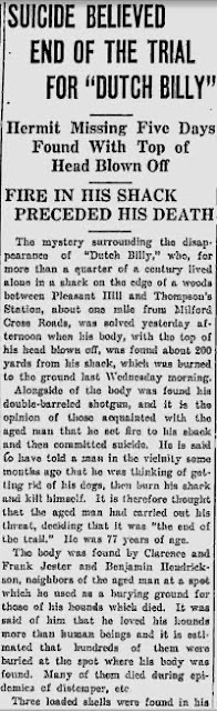
This is another item from the cache given to me by Fran Casarino, descendant of the Banks and Chambers families. (The Jabez Banks items from a previous post came from her, as well.) I don't really have a whole lot to say about it, but I thought it was certainly interesting enough to share with everyone. It's a newspaper article from 1959 that mentions an item I had seen referenced once before. One that would have been quite familiar to Mill Creek Hundred residents a century and a half ago.

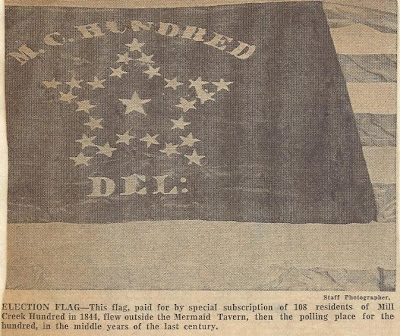
As seen in the photo on the right, the item in question is a flag, purchased by a group of MCH residents in 1844. The accompanying article, shown below, gives the rest of the story. (Reminder: click on the image to view a larger, easier to read version.) Way back (in this blog's very first post, as a matter of fact), it had been noted that the Mermaid Tavern on Limestone Road (just north of the Pike Creek Shopping Center) was for many years the polling place for the hundred. One of the reasons I chose the Mermaid for the inaugural post was that it was the closest thing MCH had to a town hall or central public location. If this was the de facto town hall, then this banner was the town flag, albeit one displayed only on specific days.


Although the article does a pretty good job of telling the story of the flag, there are a few things in particular that I wanted to point out. The first has to do with the family names mentioned as subscribers in the purchasing of the flag. The article says they are "old famly names still familiar". This should certainly be true for readers of this blog. A quick search of the site (using the search bar on the right) should come up with plenty of hits for names like Klair, Peach, Derickson, Ball, Dixon, Justis, Springer, Whiteman, and most if not all of the others. The Robert Walker mentioned as being at the top of the list was prominently featured in a post, and the Walkers who owned the Mermaid at the time of the flag's purchase were detailed in their own post. Emma Walker Pennington's father, James Henry Walker (Robert's son), bought the tavern in 1895. Descendants of the family still own it today.

Now a few comments about the flag itself. First of all, it's a pretty good size -- 8 feet by 15 feet. If it was flown from a decent-sized flagpole, it should have been visible from a ways away. And due to its size and material (silk), it wasn't cheap -- $83.50. A quick check of an internet inflation calculator shows that it would cost a little more than $2000 today. There was one thing I noticed about the design of the flag, too. If you count them, there are 26 stars in the field. 25 in the star-shaped pattern and one in the middle. On a hunch I consulted a table of state admission dates, and sure enough, there were 26 states in the Union in 1844. Florida, the 27th, was admitted in early 1845. I can only assume that the large star in the middle represents Delaware.

One final thing I found interesting was the intentional non-partisan nature of the purchase. As the article notes, the purchasers refered to themselves as "Democratic Republicans". There had been a Democratic-Republican Party, but it disbanded in the 1820's, most of its members forming the Democratic Party. Some, however, broke off to form the Whig Party, which was the other major party in existance in 1844. Less than 15 years later, the Whig Party would fall apart and the Republican Party would rise in its place. In case you were wondering, by the way, Democrat James K. Polk defeated Whig Henry Clay in the '44 presidential election.

The article states that the list of subscribers contained both staunch Democrats and staunch Republicans (although they would have been Whigs at the time). This isn't surprising, as the area was politically divided and politically active (as the Battle of the Mermaid would prove a couple of decades later). And if you think sharp, heated partisan divides are a recent phenomenon, go back and read about the politics of the 19th Century. It was at least as bad as anything today. But in this endeavor, though, even though it was politically related, these MCH residents chose to act as a unified community, and not as partisans. With all the contention today around the country regarding voting and elections, perhaps we could learn something from these 120 square feet of silk*, and the way they came about.


* -- To the best of my knowledge, the flag (which was in fact donated to the Historical Society of Delaware) is still in the HSD's collection. I'd love to be able to see it some day.

Brandywine Springs Tour -- September 21

$
0
0
Alright, I hope this isn't too last-minute of a notice, but I think we've come to a consensus. Although I did say I'd do a tour with just a few people, it seems that there are several people who can't make it this week, but can make it next week. Since this isn't anything where there's a reservation or set plans involved, I've decided to wait the extra week in order to allow more people to attend. I hope this isn't a problem for those who said they could come this week. And for what it's worth, the Weather Channel's long-term forecast has it in the 70's with a 0% chance of rain on the 21st. All in all, this seems like the best thing to do.

We can nail down a time that's best for everyone, but since a few seemed to indicate that early afternoon was good, I'm suggesting 1:00 for now. The tour should take somewhere between an hour and an hour and a half, depending on how much I ramble on. As I mentioned before, we'll walk through the park, stopping and talking about the various rides, attractions, and structures present a century ago. There are some signs in the park with pictures (installed over the years by the Friends of Brandywine Springs (FOBS)), and I'll have some additional pictures with me as well. If you don't know much about the park, I think you'll be amazed at what it was like.

In the mean time, there a a few resources available to "bone up" a bit on the history of the amusement park. You can start with my post of a few years ago (good Lord, three years ago), which gives a brief overview of the park. Additionally, FOBS has a website that contains a good history and some pictures. FOBS does now also have an excellent Facebook page, containing LOTS of pictures and features. The page is accessible to everyone -- you don't have to be on Facebook to view it. If you really want to be thorough, you can check out the twoposts about the original hotel, too.

Now we've got another week to work out any issues, but if anyone has any questions, concerns, or suggestions, feel free to speak up. Hope to see you there!!

The Whiteman Family Revisited Part 1 -- The Jacob Whiteman House

$
0
0
The Jacob Whiteman House
During a recent exchange of emails (unrelated to this post), a descendant of several local families wrote that she hoped she wasn't boring me with her "little family stories". I quickly assured her that she was most definitely not boring me. In fact, I realized and told her that these little family stories are local history. They may seem inconsequential in relation to "The Big Picture", but they can be important for any of a number of reasons. They can provide a missing piece to a larger mystery, or they can be touching stories in their own right. The stories I received recently relating to the Whiteman family certainly tick both of these boxes. (We'll actually get to those stories in the next post.) They also prompted me to revisit an old mystery.

Almost exactly three years ago, I delved into and wrote a post about the Henry Whiteman House, located on Paper Mill Road and Smith's Mill Road, just north of Foxden Road. In the initial post, I stated that the history of the home and the property didn't seem quite right to me, and I laid out an slightly different scenario which represented my best guess at the time. Even at that, it still seemed like there was something I was missing. I still didn't have a really good grasp on the family or the history of the houses in the area. Now, after being prompted with new information to go back and look at it again, I think that finally I know what the real story is (with only one slight hedge).

If you re-read the original post, you'll see that I was convinced that the history laid out for the Henry Whiteman House was actually an amalgam of the histories of two different houses. Somewhere in the middle of the story, they jumped from one to the other. I still believe that to be the case, only now I think the other house is a different one than I believed it to be before. To recap the story, here is what the 1999 University of Delaware report had to say about the history of the Henry Whiteman House:
The Whiteman family first came to Mill Creek Hundred in 1799, when Jacob Whiteman, Sr. purchased a large tract of land from Thomas Rice. By 1804, Jacob constructed a log house and a frame barn on the 196-acre property. The 1816 tax assessment for the property lists the house as being constructed of stone. This improvement coincides with the trend towards stone construction that occurred in Mill Creek Hundred between 1798 and 1820.

Prior to his death in 1826, Jacob Whiteman sold 98 acres to his son Henry. According to the 1828 tax assessment, Henry Whiteman built a stone house and a frame barn on the property during his first two years of ownership. Henry and his wife, Anna, had six children while living in Mill Creek Hundred. When he died in 1855, Henry left the 98-acre farm to his son George.

George Whiteman occupied the farm for at least five years, but by 1864, the farm passed into the hands of George's brother, Henry. It was in this year that he in turn gave the farm to their brother Andrew Jackson Whiteman. Probate records show that the farm primarily cultivated grain crops, such as wheat and oats. Likewise, potatoes and Indian corn were also grown. The family maintained a small number of steers and milk cows to supplement their farming activities. Other smaller crops included hay and clover seed.

So the first Whiteman house in MCH was built by Jacob Sr. (?-1826), and was a log home on his 196 acre tract built between 1799 and 1804. Sometime between 1804 and 1816, the log house was replaced by a stone house. If I'm correct, this house still stands a short ways north of the Henry Whiteman House, on Starling Street, just south of Polly Drummond Hill Road. (Starling Street, incidentally, was at the time the course of what's now Paper Mill Road.) Before his death in 1826, Jacob, Sr. divided his land between his sons Jacob, Jr. (1780-abt1855) and Henry (?-1855). Henry bought 98 acres (half of the 196), and the rest was left to Jacob. This is corroborated by Jacob, Sr.'s will, made in 1826: "I order that all my just debts and funeral expenses shall be paid soon after my decease. Also, I give and devise to my son, Jacob Whiteman, all that part of my plantation, which part I now live on, and bounded, and containing 98 acres and 19 perches; to have and to hold to him, my aforesaid son, Jacob Whiteman, his heirs and assigns forever."


From the 1849 Rea and Price map

As of the 1850 Census, Jacob, Jr. was still residing in his father's house, along with several of his adult children (and his sister-in-law). The 1849 map shows the property as "J. Whiteman". [The dot for the house is sort of inside the large "L". Foxden Rd. is at the bottom, Polly Drummond Hill to the right, and Henry Whiteman's house is on Paper Mill Rd.] Sometime in the intervening decade Jacob, Jr. died, passing ownership of the house to his son Jacob III (abt1825-1898). The 1860 Census shows him as the head-of-household, with his brother Israel also living there. Sometime in the 1860's, Jacob III was declared insane, and Israel (1825-1893) took possession of the family home. The 1868 map has "I Whiteman" listed for the property, and the 1870 Census shows Israel as the HoH and Jacob as "Insane". As we'll see in the next post, this was not the only instance of mental illness in the Whiteman family.

That, then, as best as I can tell, is the story of the Jacob Whiteman House. So although I don't think it's particularly clear, all the early references in the Henry Whiteman House history actually refer to this home. The story of Henry's house on Smith's Mill Road doesn't begin until 1826. In the next post, we'll review the history of this home, and pick up a few family stories along the way.

The Whiteman Family Revisited Part 2 -- Henry Whiteman and AJ Whiteman Houses

$
0
0
Henry Whiteman House, 1913
In the last post I began to revisit the story of the Henry Whiteman House, a topic I first covered several years ago. As I noted, there are actually several Whiteman houses near Paper Mill Road, between Smiths Mill Road and Polly Drummond Hill Road. (There are maybe a half dozen others throughout MCH, but we'll focus on these particular ones for right now.) We've covered the oldest of these homes, the Jacob Whiteman House built sometime between 1804 and 1816. The next one, the Henry Whiteman House, sits on what was the southern portion of his father Jacob's original 196 acre tract. Henry purchased this half of his father's land shortly before Jacob's death in 1826, and by 1828 Henry had already erected a stone house on the property for himself and his family. At the time, he and wife Anna (Kinsey) had four children, with the fourth, Henry, Jr., being born in 1827, around the time the house was completed. The couple would ultimately have nine children.

Henry resided here for almost 30 years, up until his death in 1855. At that point, the history as written in the 1999 UD report stated that the house and farm went to his son George. This was another of the points at which I was confused the first time around, since I couldn't find a George Whiteman in the 1850 or 1860 censuses. I now know why, and I also know a bit more about this man.
 
The man in question is Henry and Anna's third son, George Washington Whiteman. The reason I couldn't find him in the 1850 Census is that he was listed as Washington Whiteman. (Like his brother Andrew Jackson Whiteman who often went by Jackson or Jack, George Washington seems to have preferred his middle name.) To be quite honest, I can't really be sure exactly what transpired without seeing the property documents firsthand, but if (George) Washington did inherit the house from his father, one way or another he didn't own it long. The history was somewhat (ok, very) vague on how, when, and why the house passed to the next brother, Henry, Jr., saying only that George had it for at least five years and that it had gone to Henry by 1864. Thanks to a piece of information sent to me by Wendy Orley, a descendant of the family (we'll get to her particular line shortly), we now have a better idea of about when and why George gave up the house, and why he didn't appear in the 1860 Census. [I should also credit Donna Peters, who apparently sent me similar information a while back, but I didn't put two and two together correctly at the time. My bad.] The article below appeared in the (Richmond, VA) Daily Dispatch on February 7, 1860:
SUICIDE- The Wilmington (Del) Commonwealth learns that a sad case of suicide occurred in Mill Creek Hundred on Sunday week. A man named Washington Whiteman, who had been drinking for a long time, swallowed about 2 ounces of laudanum, from the effects of which he soon died. It appears that Whiteman some years since came in possession of a farm by the death of his father, which he sold for about $3500, and with a portion of the money, he purchased a brick store-house at Milford Corner, about which time he commenced to drink, and without attempting to do anything or improve his property, continued to drink until he had wasted his substances, and finally in a fit of despair ended his miserable life as above stated. He leaves a wife and four small children to mourn his unhappy end and buffet the waves of a hard-hearted world.

This story clears a few things up (like G.W.'s absence from the 1860 Census), but raises a few more. (Honestly, though, they could probably be answered by, "The newspaper article isn't exactly accurate.") It says he had been "drinking for a long time", then seems to say he didn't start until after the death of his father. His father, Henry, Sr., died only five years earlier. Another seeming contradiction is the fact that the UD paper states that George had the house for at least five years, although it doesn't state why they say that. The above article implies he sold the farm not long after receiving it, and certainly well before his 1860 death. Without seeing the original documents, I can't be sure what the real story was. On another level, though, none of these details make the story any less tragic for his wife and children.*

Henry Whiteman House, 1913

Whether it was due to George Washington Whiteman's untimely death, or whether it was due to an earlier transaction, the stone house built by Henry Whiteman around 1826 did eventually end up in the hands of Henry, Jr., his fourth son. Of the two remaining older sons, John Kinsey was already established on a farm east of Pike Creek, and Lemuel, to whom we'll return in a moment, had moved out of state. As best as I can tell from the census and map data, Henry, Jr. remained at the house until his death in 1884. The 1868 map shows the house as "H. Whiteman", and the 1860, 1870, and 1880 Censuses seem to show Henry and family in the same house. The only glitch is the 1881 map which shows a "W. Whiteman" in the house. But since there are no W. Whitemans in the 1880 Census outside of Israel's teenage sons just to the north, I have to assume that this is an error on the map. The 1893 map lists it as "S. Whiteman Est.", which presumably is the estate of Henry's widow, Sarah Ann (Moore).*

Stepping back a few years, though, we get a little personal story from the Whiteman clan, courtesy of Wendy, an eventual result of the story. Lemuel, second son of Henry, Sr., had married a woman named Elizabeth, who gave birth to a daughter named Mary Ann in 1844. (Mary Ann is Wendy's great-grandmother.) Elizabeth died not long after, and Lemuel remarried to a woman named Hellen. It seems that the young Mary Ann did not get along with her new step-mother, only 14 years her senior (whether this fact had anything to do with it, I don't know). Although Lemuel was still nearby in MCH in 1850, Mary Ann had gone off to live with her grandfather Henry in his home, along with her grandmother, three uncles, and an aunt. She remained after her father and stepmother moved to Cecil County, MD. In the fall of 1862, a young man named Edward Swain Past came to stay with the family. He was a 21 year old soldier wounded at the Battle of Antietam, and a relative of Anna Kinsey Whiteman (Henry's wife). Edward had been sent to the farm to recuperate from his injury.

Edward Past, c.1862 and Mary Ann Whiteman Past 1894

In what must have been a storybook romance, Edward and Mary Ann quickly fell in love, and were married in March of the following year. They spent 51 years together, until Edward's passing in 1914. Soon after marrying the couple moved out west, but returned to Mill Creek Hundred on the occasion of their 50th Wedding Anniversary in 1913. Many of the photos included in this post were taken during that trip. A number of the pictures feature the last of the three Whiteman houses in this area, the Andrew Jackson Whiteman House that stands a few hundred feet back from Paper Mill Road, across from Henry's home.

A.J. Whiteman House, 1914

It's with this house also that my understanding of the history deviates a bit from what's written in the UD report. It states that in 1864, Henry gave the farm (and by implication, the house) to Jackson. Since Henry seems to be living in the house the rest of his life, what I think may have happened is that Henry gave his younger brother a portion of the property, on which Jackson built his own house.* The fact that it doesn't appear on the 1849 map but does in 1868, plus the style of the house, seem to bolster this idea. When the Pasts came back to visit in 1913, Jackson was still residing in his house, while the Henry Whiteman House may have been owned by one of Israel's sons. The only intriguing piece of information that doesn't quite fit this story is that the A.J. Whiteman House apparently has some sort of small, stone interior section. This make me wonder if maybe Jackson didn't just greatly expand upon an older, existing stone house. If I'm ever able to find out more about this house, I'll certainly pass along the information.

Although they were not among the original settling families in MCH, the Whitemans have over two centuries of very meaningful history here (continuing to this day). There are certainly many more stories to uncover relating to the family, and at least a few more houses that I know of, to get to another day. I want to thank Wendy again for sharing some of these stories and pictures with us. These family stories (like Mary Ann and Edward's) may not seem all that significant sometimes, but I really do believe that more than anything else, they help to bring us closer to our predecessors in the area. Local history really is made of these.


*Additional Facts and Related Thoughts:
  • Another reference to Washington Whiteman, found by Donna, lists his cause of death as "fever". Not surprisingly, it seems the family might have tried to "clean up" their history. I'll have to do more research to find out exactly where his property was at Milford Crossroads.
  • Here is as good a time as any to note the very, very tight bond between the Whiteman and Moore families. Amongst the children of Henry Whiteman and Thomas J. Moore, there were no less than six marriages. John Kinsey Whiteman - Margaret Moore. Henry Whiteman - Sarah Moore. Gilbert Whiteman - Rachel Moore. Margaret Whiteman - Jacob Moore. Andrew Jackson Whiteman - Mary Moore, then Susanna Moore.
  • It was presumably in this house, then that the tragic death of Jackson's first wife, Mary, occurred in 1866. That story can be found here, and updated here.

Status Update on the Samuel Dennison House

$
0
0
Samuel Dennison House, September 2013
About two years ago, I did a post about the Samuel Dennison House located on the west side of Limestone Road, just north of Paper Mill Road. Last week I received a message through the blog's Facebook page asking me if I knew anything about the old houses on Limestone Road, around which a new development was apparently being built. I told Joanne, who sent me the message, that I didn't know anything about it, but that I'd take a ride up there and check it out. I did that over the weekend, and got a bit of a scare, then some information that put my mind at ease (at least for now).

Joanne said that from the blog she figured out that the house in question was the Samuel Dennison House, and that from what she could see driving by, she thought that it might be getting prepared either to be torn down or moved. When I got there, I could see exactly what she meant. The house now sits utterly exposed, surrounded by large stretches of barren earth, as seen in the accompanying pictures I took. All the smaller (and mostly if not all 20th Century) outbuildings have been removed, and it truly does look like the main house is about to go, one way or the other. After a quick bit of searching, I'm pleased to say that the future of the 1876 stone home seems to be secure.

I'd love to be able to say that I undertook some sort of deep Woodward-and-Bernstein-esque investigation that took me through all sorts of twists and turns, shady informants, and breathtaking revelations. But the truth is, I took a picture of the sign that was there, and went home and looked up their website. What's being built on the property is The Summit, a new retirement and assisted living community (welcome to the aging America). According to their website, they are planning on opening in the spring of 2015. When I went to the news and events page, I found the info I was looking for. One little paragraph contains the pertinent information, in the context of describing what progress they've made so far: "The first step is to demolish some of the existing buildings located on the site. We are saving two historic farmhouses that will be completely renovated, one of which will serve as our on-site sales office." Presumably the one destined to be the sales office is the Dennison House. They also include a link to a YouTube video that consists of a slideshow set to some cheesy music. Mostly it's just shots of the barren dirt and some construction equipment, but at about the 1:20 mark they start showing some pictures of the house, including some interior shots. If you're interested, it's worth checking out.

Dennison House, north and east sides
Dennison House, south and east sides

So it seems that as long as The Summit's plans don't change, both houses' futures are secure. I personally don't have a problem with historic homes being preserved and used for non-residential purposes. I'm sure The Summit's management company has a lot more money to spend on restoration than just about any private owner would. And in this case it seems like a perfect match -- an old house serving a residence for old people. (Even I'm not sure how much I'm joking here.)

Datestone reading "S & E D 1876"

On a(n almost) final note, I know the idea has come up a few times of maybe someday forming some sort of formal local history organization, like The Mill Creek Hundred Historical Society. [Unimportant personal side note: Ever since I started collecting this stuff, the history folder on my computer has been called MCHHS.] If we ever do, keeping an eye out on our remaining historic buildings, and lobbying for their preservation when appropriate, are some of the things I imagine us doing. Even if it's just showing "The Powers That Be" that there really are people who are interested in these old structures, and that we want to see them preserved.

Now, on an actual final note, you might have noticed that while The Summit's statement mentioned saving two historic farmhouses, I've so far only mentioned one -- the Samuel Dennison House. The other house being renovated sits just south of the Dennison House, and closer to the road. It's a smaller, whitewashed home partially surrounded by some small trees. This house is the David Chambers House, and is about 50 years older than its larger neighbor. More information about this home is forthcoming in a post coming soon.

Albert Gallatin Springer -- Delaware-Born Texas Cattle Rancher

$
0
0
I'm happy to say that this is another in our series of Guest Posts, kindly submitted to me by fellow readers of the blog. This one, in a way, is sort of a Guest Post once removed. Those of you who have been hanging around here a while probably recognize the name Rich Morrison from numerous informative comments he's left. Rich lives in Georgia, but his family roots go back far and wide in Mill Creek Hundred. Among the clans to which he has ties are the Springers, a family he's done a lot of research on. Rich recently retired (trying not to be jealous, trying not to be jealous..), giving him more time for important things, like genealogy. He recently connected with a professional historian named Bill Green, who had some information about an interesting member of the Springer family. Bill wrote a brief biography of the man -- Albert Gallatin Springer -- and has graciously allowed me to post it here.

I'll follow Bill's work with a few thoughts of my own at the bottom, but up here I want to forward along Rich and Bill's plea, which is for a picture. They've yet to find a photo of Albert Springer, so if by any chance anyone happens to have one, please let us know. It's a longshot, but we've already made some interesting connections through here, so you never know.


Albert Gallatin Springer

Unlikely as it seems, a Delaware native established the first cattle ranch in the Texas Panhandle. Probably born in Pencader Hundred in 1844, the youngest of eleven children, Albert Gallatin Springer grew up in Wilmington. His father, Peter Springer, reputedly was a furrier who operated the only hat shop in town before moving in the mid-1830s to White Clay Creek Hundred where he farmed for a number of years. Then, Peter retired and the family moved back to Wilmington about 1855. Albert's mother, Elizabeth Heinold Springer, died shortly before his twelfth birthday in 1856. By 1860, he was apprenticed to Wilmington blacksmith John Wesley Sullivan.

Albert probably left Wilmington during the Civil War and reputedly became a freighter on the Santa Fe Trail by the late 1860s and a buffalo hunter in Kansas during the early 1870s. He purchased 165 acres of land directly across the Arkansas River from the new town of Dodge City in December 1873, and built a house, stable, and blacksmith shop. A bridge crossed over the river from Dodge City to Springer's "ranch" in 1874, and a new road cut his property in two.

After the Red River War of 1874-1875 convinced the five Southern Plains tribes of Native Americans to stay on their reservations in Indian Territory, Springer moved to present-day Hemphill County in the northeastern part of the Texas Panhandle and established a trading post for buffalo hunters near the junction of Boggy Creek and the Canadian River. Located on the Military Road connecting Fort Supply, Indian Territory and Fort Elliott, Texas, Albert also operated a saloon and played poker with passersby, including soldiers from Fort Elliott, a frontier military post near the Texas border with Indian Territory.

Monument marking the site of Springer's Ranch

Soon after moving to the Texas Panhandle, Springer also purchased 200 cattle from a passing herd and hired a teenage cowboy named J. Thomas Ledbetter who was accompanying the herd to stay and work for him, thus establishing the first cattle ranch in the Panhandle.

Probably with the help of Ledbetter, Springer constructed a fortified complex strong enough to fight off an Indian attack that never materialized. Springer's trading post and ranching activities seemingly prospered until November 1878 when he got into an argument with some Fort Elliott troopers over a poker game. In the gunfight that ensued, both Springer and Ledbetter died. The soldiers left without burying the bodies which were discovered a few hours later by a stagecoach driver who reported the deaths to the commander of Fort Elliott.

Going immediately to Springer's ranch, Fort Elliott officers took charge of valuables there that included more than $1000 in cash, as well as two gold rings and a gold watch belonging to Springer, and telegraphed his relatives in Wilmington. A brother and two other family members traveled to the Texas Panhandle in December 1878 to settle Albert's estate which consisted of 600 cattle, his trading post, stocks and bonds, cash, and other valuables totaling near $12,000.

The military also buried Springer and Ledbetter in homemade wooden coffins near Springer's trading post, within a few feet of where they died. The graves remain there today marked by a slab of granite and a Texas Historical Commission plaque. Unfortunately, no photograph of Albert Gallatin Springer seems to have survived, or least has none been found, in spite of the fact his brothers and sisters have dozens of descendants including some, perhaps, who live in Wilmington today.

 --William Elton Green


First, I want to thank Bill Green for writing and sharing this story with us. Second, thanks go to Rich Morrison for connecting Bill to us. For a little more information about Albert Gallatin Springer, check out the Find-A-Grave memorial that Rich set up. I also want to reiterate that so far, no photos of Albert Gallatin Springer have been found. If anyone happens to stumble upon this post and actually has a picture, please let me know.

There's not a whole lot I can add to the story, except for a couple of local notes about Albert's family and early years. I've not checked to find out where Peter Springer's (Albert's father) original farm was, and where Albert would have been born. However, Peter's second farm, where the family lived from about 1835 to about 1855, does appear on the 1849 Rea and Price map. The farm is still there, even if the actual house doesn't seem to have survived. It's located on Route 2/72 South Chapel Street/Library Avenue, on the east side of the bend where it meets with Old South Chapel -- about halfway between the railroad tracks and Chestnut Hill Road (Rt 4). The farm is now owned by the University of Delaware.

As for the family, the Springers go back to the earliest days of European settlement in Delaware, and therefore were pretty spread out by the 19th Century. Several lines on the family have been mentioned in the blog before, but the closest would have been John Springer, owner of the Springer-Cranston House on Stanton Road near Marshallton. John was Peter's brother, and Albert's uncle. The Peter Springer who ran the Rising Son Tavern in Stanton was a cousin of John and Peter's father. Frankly, going much further into the family is more confusing than it's worth right now. I think it's very interesting, though, to see how one of these Springers actually had a significant (and fascinating) impact on the wider world outside of New Castle County.

The David Chambers House

$
0
0
David Chambers House, September 2013
Recently I reported on the status of two historic homes on Limestone Road, located just north of Paper Mill Road. The larger and more prominent of the two houses (which will both be saved and renovated) was the Samuel Dennison House, built in 1876 and now standing completely exposed on the property cleared for construction
(as of October 2013). The history of this house has already been covered, and can be found here. However, there is a second house on the property, which even though it sits closer to the highway is less conspicuous due to surrounding foliage. This house, which is actually about a half century older than its larger neighbor, is the David Chambers House.

The David Chambers House is a two story, stuccoed fieldstone home with 20th Century additions on its west and south sides. The main block has four unevenly-spaced bays, with the main entrance set in the middle right bay. A faint line over the first floor windows hints at a front porch, long since removed. As of this writing, small trees help insulate the house from the widened and encroaching Limestone Road out front.

The history, especially the early history, of the house is at once both detailed in some places, and frustratingly vague in others. We know that the property, which included the Dennison House tract, belonged in the late 1700's to Abraham Holmes, who died sometime just before 1800. After his passing, the property went to Josher Holmes, officially transferring in early 1804. Although I don't know for sure at this point, I would assume that Josher was Abraham's son. The administrators of the will were Jonathan Holmes and Isaac Dixon. Jonathan was either a brother or another son, but I do know that Isaac Dixon was Abraham's son-in-law, married to his daughter Julia Ann. (Isaac and Julia Ann's son was Jesher Dixon, so the name, which I've seen both ways, must have been in the Holmes family.)

Josher Holmes only ended up spending about a dozen years on the property, apparently falling upon hard times. He mortgaged the property to Isaac Chambers, but ultimately lost it to him in late 1815/early 1816. It's never made quite clear, but this DelDOT report seems to say that the house was in place at least by this date. It may have been built by Josher Holmes, or may very well date to the 18th Century and the ownership of his father Abraham. I'll update if more information comes to light about the construction date of the house.

David Chambers House, 1986

However old the house was at the time, the Chambers family would end up owning it for more than a hundred years. For as big as they were, I've had difficulty finding a good comprehensive genealogy of the Chambers family, but I have been able to piece a few things together. Isaac Chambers was a part of the same Chambers family that owned the Hopyard tract and had multiple holdings in the western MCH-eastern White Clay Creek Hundred-southern Chester County area. If Isaac ever did actually live in the house (and the 1820 Census seems to indicate that he did), he didn't stay for long. In March, 1821 he divided the property and sold part (the later Dennison tract) to Richard Chambers (1775-1863) and part (with the existing house) to David Chambers (1787-1852). I'm fairly certain these were his brothers. I had originally fallen into the trap of assuming, "House going from one family member to another must be father to son", but several things make more sense if David is Isaac's brother. Richard turned around and sold his portion three years later to Robert Dennison, but his bloodline would eventually return to the area.

David Chambers would remain in the house, along with his wife Elizabeth, until his death in 1852. He can be seen listed in the house on the 1849 map. After David's death, the property was divided, with Elizabeth receiving 28 1/4 acres, including the house. Since the couple had no children, the remainder was divided between several of their nieces and nephews. The largest portion went to John W. Chambers (1816-1869), the son of Richard Chambers (the guy who sold the Dennison property). The DelDOT report then says, "John W. Chambers eventually obtained possession of Elizabeth's 28 1/4 acres, and when he died in 1869 his widow, Mary Jane, inherited the tract." I don't have the original documents that they were presumably using, but I do question a couple things about this story, or at least what's implied. (Knowing full well that it could just be me misunderstanding it.)

While we know that David Chambers did live in the house for about 21 years, I don't think that John W. Chambers ever did. To be fair, though, the DelDOT paper doesn't explicitly say that he did. John had already inherited part of the family land along the White Clay, and built a new home called Hilltop in 1851, a year before coming into the property on Limestone Road. Hilltop was located in the very northern tip of White Clay Creek Hundred north of Newark, and the 1860 Census clearly has him living there. In the 1870 Census Elizabeth Chambers (David's widow) is still listed next door to Samuel Dennison, and is shown as owning the house. Both the 1869 and 1881 maps show the house as "Mrs. Chambers". I don't know for sure who owned what when, but Elizabeth does appear to have continued to reside in the house.

The history then states that in 1889 Mary Jane conveyed the property to her son, Isaac Newton Chambers (1834-1910). Here we have several problems. First, John W. and Mary Jane Kemble Chambers were married in 1841, and I'm relatively certain that Isaac Newton was not their son. He may have been a nephew. Secondly, as early as 1860 he seems like he may have been living in the house, although he didn't own it at the time. Perhaps confusing matters is that there is another John Chambers (not John W.) who owned a farm just south of here (the house and barn are still there, south of Ocheltree Lane, now the offices of Duffield Associates).

Also potentially confusing things (or at least, me) is that there used to be one other house nearby. There was another John Chambers House that stood on the northwest corner of Limestone and Paper Mill, probably about where the turn lane is now. It was razed in 1964 when the road was widened. This home was also made of stone, and although it doesn't appear on the 1849 map, it looks like it was older than that. I wonder if maybe it was a tenant house on the David Chambers property, then separated when his land was broken up. Since most of this doesn't seem directly related to the David Chambers House, a full analysis of who lived where during this 30 or 40 year period will have to wait until another day.

John Chambers House, before demolition in 1964

Whenever it was that Isaac Newton Chambers gained ownership of the house, he retained it until his death in 1910, at which time it went to his son William H. Chambers. (Yes, he does actually seem to be his son. Yea!)  William owned the home until 1928, when he was forced to sell it in order to pay off a mortgage debt. The purchaser of the house in 1928 was William P. Naudain, who shortly thereafter in 1930 undertook some renovations to the century-plus year old home. He added an addition to the rear, and built a garage onto the south end.

For such a simple-looking and easily overlooked home, the David Chambers House has a confusing and convoluted past. At least its future seems to be safe. If further investigation leads to any clarification on any of the Chambers properties along Limestone Road, I'll be sure to pass it along.

Ephraim Jackson House and Mill

$
0
0
If it seems sometimes like there's no particular rhyme or reason to what I write about at any given time, that's only because there isn't. One of the things this blog is meant to be is a documentation of my own journey of discovery through Mill Creek Hundred history. And that journey is about as straight a line as one of those old Family Circus comics. Once in a while a few posts will connect to each other, but more often than not I'm all over the place. The other day, as I was trying to decide where to focus next, I got an email from someone asking about a certain house (thanks, Julie!). As it turns out, I knew a little about it (although not as much as I thought I did), had mentioned it once before in a post, and always meant to get back to it. So since I'm that easily influenced, we'll take a look at a beautiful tucked-away house whose secluded location belies its significance to its area's history -- The Ephraim Jackson House.

The two story brick house is probably one of Hockessin's oldest, and sits on the south side of Evanson Road, most of the way down to Mill Creek Road, coming from Valley Road. There doesn't seem to be any firm date for the construction of the house, but a look into the property's history does lend some clues. Most of the information I was able to find came from Joseph Lake's book, Hockessin: A Pictorial History, with help on the early years from the research of Walt Chiquoine. There are still a few parts of the history that aren't exactly clear (especially towards the end), but a general story does emerge.

The story begins with the Dixon family, already featured in several posts (like here, here, and here). Their whole story is a post all to itself, but for now suffice it to say that their land came from an 800 acre purchase by John Houghton about 1715. Houghton was married to Ann Dixon, the widowed mother of four sons. Each son received a quarter of the tract, with Henry Dixon buying his part in 1718. His is the left-middle portion of the large rectangle below, the left one with pink borders. In 1721, Henry purchased an additional 130 acres to the north, on which the Dixon-Jackson House stands. He sold part of the northern tract in 1725, and when he died in 1738 the remainder of his land (two tracts of 61 and 190 acres) were passed to his son Samuel. If you get your bearings in the picture below (Lancaster Pike and Valley Road intersect about in the middle), you can see that the current Evanson Road pretty much bisects Henry's (now Samuel's) southern tract.

Dixon holdings in Hockessin (courtesy Walt Chiquoine)

The next time this property appears in the historical record is in 1771, when Samuel Dixon sells his property (both tracts) to James Jackson (1736-1817). According to Lake, in that transaction Jackson purchased, among other things, a house and a mill. It's unclear at this time whether the house refered to is the Dixon-Jackson House on the northern property (which Jackson and family did move into), or if it's a separate house near the mill on the southern tract. In all likelyhood Samuel resided in the house on Lancaster Pike, but the brick house near the mill could have been erected as a miller's house. There's no firm evidence for the build date of the mill, either, but if it was present by 1771, then a good guess would be that Samuel Dixon erected it sometime between about 1750 and 1770.

Whether or not the brick house was there yet, later maps do show us where the mill was located -- behind the house, about halfway between it and Mill Creek. A mill race ran north-south past the mill, cutting across the bend in the creek. James Jackson is noted to have operated the saw mill, but at some point it seems to have been taken over by his son Ephraim (1766-1843). In the 1804 county tax assessment, Ephraim Jackson is listed as owning a saw mill. It's interesting to note that unlike most mill seats, this one only ever hosted a saw mill. No grinding stones were ever installed, and no grain milling was ever done. The mill would have had an up and down blade, as circular blades were a later European import and never really caught on in the mills around MCH. The boards cut here would have likely been used locally in houses, barns, and other structures.

Ephraim Jackson moved into the Dixon-Jackson House with his family when he was five. He grew up here, but after his father's death in 1817 the family home went to his brother Thomas (father of John G. Jackson). Lake mentions a sale of 108 acres, a house, and a mill to Ephraim in 1816, a year before James Jackson's death. I've not seen this documentation, but I surmise that this may have been a formal transfer to him of the property and mill on which he was already living and working. If it turns out that the house was not built during the Dixon tenure, then I think it's likely that Ephraim built it, perhaps around the time of his marriage in 1786. Further study of the 1771 deed may yet provide an answer to this.

Hockessin area, 1849

After Ephraim Jackson's death in 1843, the house and mill passed to his son, Haines Jackson (1797-1861). It's Haines who is the "H. Jackson" listed by the house and mill on the 1849 map. Although it must have been operating then, it was certainly old and probably outdated. Haines* (or Hayns, as he's listed) is listed as a farmer in the 1850 Census, so any saw milling he was doing may have been a side operation by that point. He sold the house and mill in 1857 to George Springer, who had recently built a new home just north on Valley Road. And though Lake notes that Springer liked the house, it's all but certain he did not live there. Under Springer, the mill may have been used even less, if at all. It's not even noted on the 1868 map.

Since he already had his own home, Springer likely rented the farm out. In 1877, he sold the property to another man who bought it as an "investment property" -- John Mitchell. John Mitchell(1818-1897) had already bought, renovated, and sold several properties, and this was certainly his plan here. Like Springer, Mitchell didn't live in the house, as he resided in Ocasson, the Cox-Mitchell House on Old Wilmington Road. And like he had done with his previous purchases, Mitchell made some upgrades and renovations to the old Jackson home.

First, he renovated the house, which may have been more than a hundred years old at that point.* He also upgraded the mill, adding a steam engine that either complimented or replaced the water wheel. Finally, Mitchell supposedly started a creamery in one wing of the mill. In 1888, he leased the creamery to C.G. Gallagher, who converted the entire structure into a creamery. Scharf reports that in 1888 Gallagher was producing 175 pounds of butter per day for transport to Baltimore and Wilmington, presumably on the Wilmington and Western Railroad, by then a part of the Baltimore and Ohio. Mitchell sold the creamery in 1899 to his son Stephen H. Mitchell, who continued the lease to Gallagher. Sometime in the early 20th Century the mill was destroyed in a fire. Or not.

Here we get the other point of confusion regarding this house and mill to go along with its early years -- its later years. Like many times before, I'll preface this by saying it's possible that I'm just misunderstanding it in some way. If so, anything that can help lift the veil of confusion would be appreciated. Lake writes that Mitchell enlarged the mill, and that it was so large that one wing was occasionally used as a dance hall, and for a brief time served as an overflow schoolhouse. However, in another part of the book he shows a photo of "the creamery" that was used this was, but states that it sat on the southeast corner of Lancaster Pike and Valley Road. If that location is correct, then there were two creameries in Hockessin, and it was not the Jackson-Mitchell one that was the big one.

I suppose that one other possibility is that John Mitchell bought both properties around the same time, and that the creamery and the old Jackson saw mill became confused. This almost seems to make more sense to me, as it seems odd that Mitchell would or could enlarge a small mid-18th Century saw mill to the size that's implied. If anyone can clear this mystery up, I'd appreciate it greatly.

Whatever the case was, it seems the saw mill and the creamery (whether one structure or two) were out of service by the early 1900's. The old brick house, though, survived. Today it stands, secluded in its location just out of reach of modern, bustling Hockessin, as a reminder of the early days of the region's settlement.


Additional Facts and Related Thoughts:
  • I'll add this one only because I love finding and making connections between families, especially ones I've featured before. Haines Jackson was married to Ruth Heald, sister of Joshua T. Heald.
  • Since it seems like just about every house that John Mitchell renovated is still standing and in good shape, I think it's fair to say that he's personally responsible for their continued existence. Thanks, John!

The Henry Clark Woollen Mill

$
0
0
Sunnybrook Cottage
From the late 17th Century through the early 20th, Mill Creek Hundred was home to numerous water-powered mills. For obvious reasons of power, most were seated where you would expect -- along the main waterways of the region (Red Clay and White Clay Creeks) or their major tributaries, like Mill Creek and Pike Creek. A few, though, sat on smaller streams where, frankly, you're likely to look at them and say, "There was a mill powered by that?" One of those streams (which actually hosted at least two mills), was the usually tame Hyde Run, which winds its way from north of Loveville down to join the Red Clay in Brandywine Springs Park. And for nearly 100 years, in a now-wooded area east of Newport Gap Pike, stood a textile mill.

The story begins, though, more than a century before any cloth was manufactured on Hyde Run, or Great Run as it was referred to in the oldest documents. The property was originally part of a larger 239 acre tract purchased in 1689 by Bryan McDonald (or McDonnell, or MacDonald, or McDannell, or...don't even go there), of which this was in the northern part. It went next to Brian, Jr., who in 1747 sold his holding at the time to Jeremiah Wollaston. Wollaston in turn sold a 147 acre portion of the tract to George Robinson in 1757. Its location can be seen in the illustration below.

Disposition of McDonald land (courtesy W. Chiquoine)

From this point, the property stayed in the Robinson family for about the next 75 years. I wish I could say a bit more about the Robinsons, but information about these particular individuals has been hard to come by. I think there's a strong possibility that they're the same family that owned land and the mill at Milltown. There were marriages around this time between members of the McDonald, Wollaston, and Robinson families, so there's reason to believe that the men involved in these early transfers at least knew each other well, if they were not somehow related.

The next time (I believe) the property shows up is in a listing in the 1804 tax assessment, as related by Scharf. John Robinson is listed as having a grist mill, one which Scharf labels as "forgotten". There is no note as to where this mill is, but I believe it was located on Hyde Run, across from Emily Bissell Hospital. Although I've not yet been able to find out for sure, I'd assume John was related to George, quite possibly his son. At that point, John's was strictly a grist mill. Textile manufacturing was a relatively small-scale affair at the time, and there were very few textile mills in the area. For a number of reasons having to do with supply, demand, trade, and tariffs, textile manufacturing in the region (and in the US in general) exploded around the time of the War of 1812. It was likely then that John Robinson began doing custom carding of cotton (straightening the fibers so they can be woven) in his mill. He is mentioned as doing such in 1816. He obviously wasn't all that successful in his venture, as his property was sold in 1821 by Sheriff John Moody for the repayment of debts. [Although to be fair, the wartime boom soon crashed, and many textile mills fell on hard times, as seen by the troubles of the larger Madison Factory not far away. But see the note below anyway.*]

Possible ruins of the Clark Woollen Mill

The new owner in 1821 was James Robinson. As with George and John, I don't know for sure the relationship to James, but I think it's safe to assume he was related. What James bought from Sheriff Moody was two tracts, one of 40 and one of 66 acres. The smaller one was described as containing a log dwelling house, frame barn, grist mill, dam, and race. The second tract contained only a log house. Since there is no mention of a cotton mill -- only a grist mill -- this implies that either John had given up on textiles, or it was sort of a side job for the grist mill. Carding was done under James, though, reportedly by a Robert Robinson. (Yeah, again, sure related, don't know how.)

In or about 1833, the mill was hit by a fire. In that year, James Robinson sold the mill tract (now listed at 50 acres) to James Donnell. Interestingly, Robinson retained the right to use the road over the breast of the dam to get between his farm and Newport Gap Pike. This shows that the 66 acre tract he retained was situated to the east of the mill tract. The next chapter in the story began the following year, when Donnell turned around and sold the mill to Henry Clark (1798-1886), a woolen miller from Sussex County.

More potential mill ruins

Clark had recently begun a wool carding and spinning mill in Sussex County* in 1831. According to the 1832 McLane Report, he produced 300 yards of woolen goods in his first year. Upon moving to MCH, Clark began a fulling mill at the site of the Robinson mill. Whether he built a new structure or adapted and repaired the old one is unclear. While he originally did only fulling (the process of cleaning the cloth and making it thicker), by 1845 Clark was also producing small quantities of cloth. No doubt, his sons William and James* worked side by side with Henry in the mill and learned the business. In 1862, the two Clark boys purchased the Auburn Cotton Mill in Yorklyn from Jacob Pusey, which they then converted to work wool. It seems that James stayed on with his father at the Hyde Run site (probably taking over the day-to-day operations from the aging Henry), while William moved up to Yorklyn to oversee the mill there. There is mention of the two mills working in concert, but no details of this arrangement have yet been found.

Henry Clark (or more likely, James) continued to operate the mill until the early 1880's. In 1882, all but one room of the mill was leased to Abraham Marshall and Anderson Smith. That same year, a trade magazine listed the mill's equipment as one carding machine, four looms, and 144 spindles, making it a fairly small factory. After Henry Clark's 1886 passing, the property went to his son James, who died a year or two later. It then passed through several hands before being purchased by the Delaware Anti-Tuberculosis Society in 1910. The mill was certainly out of commission by then, probably ceasing operation in the early 1890's. The property became part of the Hope Farm/Brandywine Sanitarium/Emily Bissell Hospital.


There's never been any official archaeological work done to determine the site of the woolen mill (that I'm aware of), but there may be some clues to its location. Of the four 19th Century maps (1849, 1868, 1881, 1893), all but the 1849 show it on the west side of Hyde Run, behind the house. There are several locations with ruins around there, made more confusing because the sanitarium built several sewage and waste treatment facilities along the creek. Several sites are clearly these later structures, as they're built from brick and concrete, and look like 20th Century buildings. One though, shown in the accompanying photos, looks older and at least the base of it is built of fieldstone. It's almost exactly where the three maps show the woolen factory, but it probably is not it. The photo below is from 1939, and the ruins are likely the base of the large white barn to the right (thanks for the tip, David Z.).

Area behind Sunnybrook Cottage, 1939

The TB hospital also made use of the large house on the property. There doesn't seem to be much recorded history of the home except for one brief mention, but we know from the Robinson deeds that it was not present in 1833. A house does appear on the 1849 map (and the later ones) in the same location as the present house, though. In a 1959 paper, Carroll Purcell offhandedly notes that in 1858 the Delaware Weekly Republican noted that Henry Clark had recently built a new two-story home. Presumably this is the house still standing, possibly replacing an earlier home on the site dating to the Robinson tenure. In the early 20th Century the house served as Sunnybrook Cottage, a home for children exposed to, but not showing symptoms of, tuberculosis. More recently it has come into the possession of the Delaware Association for the Blind, for whom it serves as a camp for children.


Additional Facts and Related Thoughts:
  • I found here a reference from 1818 to the legal troubles for a "John Robinson, now, or formerly, a resident of Mill Creek Hundred". It seems this John Robinson was caught passing a counterfeit bill, tried, and convicted. He was sentenced to prison, given a hefty fine, and forced to wear a scarlet "F" sewn onto his clothes. Yes, that was apparently a real thing even that late. I don't know if this was the same guy who ran the mill, but if so it would explain why the mill was seized and sold.
  • Well, Henry Clark's first woollen mill was probably in Sussex County. His entry in the McLane Report lists him as being in Sussex, but his answer to question 1 says he's in New Castle County. To confuse things even further ('cause that's just how I roll), the only Henry Clarks I can find in the 1830 Census are in Kent County.

Possum Park

$
0
0
Unlike other times when I've made this statement and been wrong, I'm pretty sure this will be a short post (at least compared to some recent ones). In fact, stick around a few paragraphs and watch me dig really deep for some facts to throw in. This post came about the other day when I was trying to gather some information about the origins of the name of a particular road -- Possum Park Road, to be precise. In case you're not familiar with it, Possum Park Road runs north from Kirkwood Highway to Milford Crossroads, just east of Newark.

The road itself long predates the name, and was in place before 1820. At that time and at least as late as 1912, the thoroughfare was known as the Hop Yard Road. The Hop Yard tract was a large and old property occupying the northern part of Milford Crossroads, on the north side of Paper Mill Road. So when and why did the name change from Hop Yard Road to Possum Park Road? I've never found an explicit explanation, but a big clue lies on the 1868 Beers map, located in the upper right of this page.

"Bossom Park" on the 1868 Beers Map

About halfway up this road from Roseville (along today's Kirkwood Highway) to Milford Crossroads (where the complex formerly known as Louviers stands), there is listed a property on its western side. Although there are likely two separate errors here, it very strongly suggests a source for the unusual moniker. The owners of the property are listed as "H.J. & J.C. Johnston", and above their names is "Bossom Park". Since Bossom Park doesn't make much sense for an estate name, I think it's safe to assume that this is supposed to be Possum Park. In the research I've done, I've not come across any other references to Possum Park other than this map, and of course the later name of the road. This leaves the only other clue as the house and the people shown on the 1868 map.

Here is where we get the other error, albeit a slight one. The men listed on the map are brothers Hiram J. and John C. Johnson. They were born in about 1830 and 1835 respectively, and were the sons of William and Jane Johnson. William Johnson was born about 1799, and is shown on the 1849 map as having his main residence on the east side of the road, just above Possum Park. An unlabeled house is shown in 1849 at the Possum Park location, and William's house is still owned by the sons in 1868. In fact, both properties stay in the family at least through the 1893 map.


As you can see in the pictures, the house I'm assuming is Possum Park is still standing (a fact I wasn't aware of until recently), and currently houses a doctor's office. It's an unusual looking house, and seems to consist of what looks to be an older stone section and a later wood-shingled frame addition. If this is indeed the case, the frame addition was added to the gable end of the older block, and may have changed the "front" of the house from the northward-facing facade to the eastern (road-facing) side. It's possible that the stone section could be a rear addition to the frame part, but that would be an unusual order of building materials.


In either case, the house does have an atypical set-up. This fact became slightly less mysterious when I looked at the census records and learned that Hiram and John Johnson were both "House Carpenters". Knowing this, I think it's logical to assume that they themselves either built, or at least added on to, the house. Since they were home builders, it's believable that they would do something a bit different with their own house.


So far, additional facts (such as they are in this case) are a bit thin. The later maps (1881 and 1893) show both houses as belonging to John Johnson, who likely owned them until his death in 1899. Brother Hiram had either died or moved away, as he doesn't appear after the 1870 Census. Property in this area (presumably Possum Park) was passed on to John's son, also named John. He is seen residing in the area well into the 20th Century.

If more information comes to light about this house whose name is far more well-known than it is, I'll be sure to pass it on. And speaking of the name, one has to assume that it came from the presence at some point of its namesake mammal. The opossum is the only marsupial native to North America north of Mexico. It's technically the Virginia Opossum that we have around here. Possums are Australian marsupials similar to the opossum. The name comes from the native Algonquin name for the same animal, which means "white animal". Opossums have been around for at least 70 million years, making them one of the oldest of the mammals. The more you know...

Mid-Week Historical Newsbreak: Animal Anomalies

$
0
0
Welcome to the first of what I hope will be a regular feature (at least for a while) here on the Mill Creek Hundred History Blog. For a while now I've had a random assortment of very short historical newspaper clippings, but I could never quite figure out what to do with them. Very rarely have I been able to find out much, if any, additional information about the stories, and, well, you know how I am. I don't usually like to post stuff unless I feel I have something to add, even if it's just pulling a few things together. Because of that, I've only ever posted a few of these clippings here and there, normally when they're somehow connected to a larger story.

A good number of these clippings have come to me from Donna Peters, and recently she sent me another good batch. Since I can't justify holding on to them any longer, here's what I've decided to do. For the foreseeable future, once a week (probably about Wednesday) I'll post one or two of these clippings as a Mid-Week Historical Newsbreak. Depending on the selection, there may or may not be much in the way of accompanying text. Even if so, it may be as simple as, "The farm mentioned was located here", along with a map snippet. I hope you enjoy these brief glimpses of the past.

We'll start out this week with a pair of articles highlighting odd animal behavior, separated by 50 years. The first one comes from the (Washington, DC) Evening Star, dated July 1, 1857. It reports on some strange goings-on regarding local flocks of pigeons in the area of a particular farm.


The farm in question here, belonging to James Denney, is located just south of the CSX railroad tracks, on the west end of one of the Delaware Park parking lots. An old farmhouse still stands there today, probably the same house noted as J. Denny on both the 1849 and 1868 maps. A while back I had incorrectly speculated that it this house might have been that of James Brown, brother of The Farmhouse's owner and apparently later the owner of his own racetrack. After looking again at the maps, it seems obvious that Brown's house was more or less on the infield of the modern racetrack, while the farm to the west was that of James Denney.

The second article this week comes from the November 24, 1907 edition of the New York Tribune. It tells the tale of some strange reactions by rabbits.


The trolley line the article references was the West Chester, Kennett, and Wilmington Electric Railway, better known as the Kennett Trolley. The line went into service in 1903, running from Kennett Square down to Brandywine Springs Amusement Park. A future post will someday go into more detail about this line, which despite its grandiose name, never got as far as either West Chester or Wilmington. It did, however, apparently succeed in scaring the pellets out of MCH rabbits. Would have made for some great You Tube videos, though.

Mid-Week Historical Newsbreak: Train Mayhem Edition

$
0
0
This week we have a couple of iron-horse-related stories, sent to me by Donna Peters. They both come from the 1890's and occur along the Philadelphia, Wilmington & Baltimore tracks near Stanton. This is the present-day Amtrak line just south of the village. I don't know what they say, except that life has always had its dangers.

From the Alexandria (VA) Gazette, December 7, 1893:


From the (Flagstaff, AZ) Coconino Weekly Sun of October 8, 1896. Ouch.

Mid-Week Historical Newsbreak: Lost and Found Department

$
0
0
For this week's Historical Newsbreak, we'll keep it shorter and lighter. It comes to us from the August 2, 1904 edition of The Washington Times.


Yes, not particularly historically notable, especially in a week that sees major anniversaries of the Gettysburg Address and the Kennedy Assassination. Still a cute little story, though. The lucky farmer was Richard S. Fisher (1848-1925), the son of English immigrant Richard G. Fisher (1809-1885). I don't have the portion of the 1893 map that would show him, but I'd assume that his farm was the same one his father had owned since at least 1868. It was located east of Old Wilmington Road, south of Brackenville Road. The farmhouse does not appear to have survived, but I believe the property is now a part of the Mt. Cuba Center. The Fisher family is interred at Red Clay Creek Presbyterian Church.

The Armstrongs of Hedgeland

$
0
0
The Armstrong Estates in 1868
One phenomenon that I've run across in my research that I've always thought was interesting was how certain families end up controlling certain areas, with multiple adjacent or near-adjacent farms all owned by relatives. Often this is a result of an early, large tract being broken up over the years but staying within a family, or by related men purchasing farms near each other (or a combination of both). We can see this with a few families in Mill Creek Hundred, like the Whitemans, the Eastburns, the Walkers, the Dixons, and the Jacksons. Another good example can be found just over the border in the southwestern part of Christiana Hundred, around the intersection of Centre Road (Route 141) and Faulkland Road.

The family that controlled this particular area was the Armstrongs, and their legacy can still be seen if you know where to look, although one highly-visible example recently disappeared (that's actually what got me interested in this in the first place, and we'll get to it in the next post). The Armstrongs, as I quickly learned, are one of those very old families that has semi-related (or possibly not related) branches in several places around New Castle County. The farther you go back, the more difficult it becomes to sort out exactly how everyone is related to everyone else. It didn't take me long to realize that I really just wanted to focus on the branch that settled near the 141/Faulkland Road area.

The biographical information I could find about the family, which mostly came from Runks, seems to generally start with Robert Armstrong (1743-1821). About the only piece of information given about him is that he fought in the Revolutionary War, which is plausible given his dates. And just a quick note about these dates -- this is one of those families where the more I dug, the more confused I became. Many of the dates given in Runks don't match up with dates in other genealogical sources, or even with some of the headstones of the people. I'm using the dates which make the most sense to me, but I'm not staking my life on any of them.

The Armstrong Estates in 1881

This Robert seems to be the son of another Robert, who in turn is likely related to (may be the son of) John Armstrong, whose 1726 burial is said to be the oldest at St. James Episcopal Church west of Stanton. From both the church's and likely the family's earliest days in America, the Armstrongs (or at least, this branch) were strongly involved in the congregation at St. James. Almost all of the people mentioned in this post are buried there. The Patriot Robert Armstong's home farm was known as The Hedge, or Hedgeland. It was located on the northeast corner of Centre Road (141) and Faulkland Road, the present-day location of DuPont's Chestnut Run offices. It sits directly across the road from the Ferris School, which was once an Armstrong farm called Woodside. Woodside was sold out of the family very early in the 1800's, but was owned before that by William Armstrong. I haven't definitively placed him in the family, but he may have been Robert's uncle.

I've found no mention of where the earliest generations of these Armstrongs lived, but it's possible that it could have been Hedgeland. Robert the Patriot (whose wallet resides with the Historical Society of Delaware) was reportedly born in Christiana Hundred, and his son Robert (1782-1838) is specifically said to have been born "on the Hedge farm". This Robert, like his father before him, took up arms to defend his country, this time in the War of 1812. He is said to have been active in politics (although not an office holder), and was "one of the pioneers in the establishment of the Wilmington markets". Robert and his wife Elizabeth (Mehaffy) had six children, the youngest of whom was a son, Robert Louis Armstrong (1834-1909).

Robert Lewis' father died when he was just four, so his mother had to run the farm until he came of age. When he did (and after spending three years at a boarding school in Wilmington) he made great improvements to the estate, including a new stone house and a large barn. This makes sense when you figure that what was there was probably built at least by his grandfather (if not earlier), and was probably pushing a hundred years old by that point. In 1864 Robert Louis became the third generation in his family to fight for the United States, when he enlisted in the Second Regiment, Delaware Emergency Cavalry. He also carried on the family tradition of public service, serving in several positions over the years. At various times he held the office of Assessor for Christiana Hundred, Tax Collector for the hundred, New Castle County Sheriff (1872-1874), and member of the Levy Court. Robert also served as a committee chairman at Ferris, and as a senior warden, trustee, and vestryman of St. James Church. On top of all that, he was also a past master of the Armstrong Masonic Lodge in Newport, which was named after him.

Robert Louis Armstrong lived the rest of his life at Hedgeland, before passing away in 1909 and being interred at St. James. As best as I can tell from old aerial photos, the Hedgeland house stood just back of the main gates going into Chestnut Run, maybe about where the flagpole is now. And as much as I learned about Hedgeland and the Roberts Armstrong, this wasn't even what I initially set out to study. Two other 19th Century Armstrong farms, of which one house remains, will be the focus of the next post.

The Armstrongs of Woodland and Brookland

$
0
0
Brookland
In the last post, we began looking at the Armstrong family of southwestern Christiana Hundred, a portion of which they came to dominate in the 19th Century. We saw four generations of Robert Armstrongs, at least three of whom lived on the farm called Hedgeland, located at the present-day site of DuPont's Chestnut Run facility. The funny thing is, this is not even what I started out researching. Initially I was looking into two other Armstrong properties -- Woodland and Brookland -- situated west of Centre Road (Route 141) and south of Faulkland Road. The recent removal of the Woodland name (which I doubt many people knew dated back at least 200 years) from a prominent place along the road got me thinking about the area, which in turn lead me down the whole Armstrong family path.

In the Armstrongs of Hedgeland post I noted that most of the family biographical information (which primarily came from Runks) began with Robert Armstrong (1743-1821). It said little other than A) he served in the Revolutionary War, B) owned a farm called "The Hedge", and C) had two sons, Robert and William. In the first post we followed the line of son Robert. In this one we'll take a look at William and his descendants.

William Armstrong (1777-1840) was likely born on his father's Hedge farm, as best as I can tell, in 1777. As noted in the last post many of the dates for the Armstrongs tend to vary from place to place. In the Runks biography of one of his grandsons, it states that William fought in the Continental Army during the Revolution. If this date of birth is anywhere close to correct, I think we can safely rule that out and say that he actually fought in the War of 1812, like his brother Robert. It would have been in this conflict then, that William rose to the rank of Major, a rank he proudly wore the rest of his life (and beyond -- his headstone id's him as Major William Armstrong).

If William grew up at Hedgeland as seems reasonable, he soon moved away to his own farm, but not very far away. By at least 1806, William was residing at the farm he called Woodland, a name still very much in use, although I doubt many know the name dates back over 200 years. Woodland occupied the southwest corner of 141 and Faulkland Road, with the manor house probably sitting near the back of the apartment/condo complex, until recently, known as Woodland Terrace. (Its name change to "Greenville at 141" is what got me thinking about the area in the first place.) Having not seen any property records relating to the tract, it's unclear whether Woodland was a part of the larger family holdings, or whether William purchased it himself. Major William Armstrong lived on his Woodland farm until his death in 1840, after which he was buried at St. James Church near Stanton, like so many in his family.

The Armstrong area in 1868

Maj. Armstrong and his wife Ann had eight children, the first five of whom were sons. Of these boys, Robert (the oldest) moved away to farm first in White Clay Creek Hundred, and then in Pencader Hundred. The youngest, George, moved to Wilmington. Second son John Paulson (1808-1885) purchased his own farm, Oakland, located west of Centerville Road near today's Little Falls Corporate Center. The other two sons stayed even closer to home. After Maj. Armstrong's 1840 passing, ownership of Woodland went to the fourth son, James Armstrong (1818-1873). James lived the rest of his life at Woodland, after which it remained in the family.

The remaining son, William Armstrong (1815-1890), third child of Maj. Armstrong, would eventually cultivate the last of the Armstrong estates in the area. William was born at Woodland in 1815, although this is an example of the dates not agreeing in different sources. Runks says he was born in 1806, the 1850 Census implies 1820, but his headstone says 1815. For our purposes, I'm going with the date literally written in stone. Whatever the true date was, William grew up at Woodland, then as a young man trained to be a blacksmith. He moved to Wilmington where he worked in that profession, before eventually returning to Christiana Hundred about 1850.

Like some of the personal dates surrounding the family, that 1850 date for William's purchase of Brookland seems to be an approximation. Since the Runks tome that it came from was written nearly a half century later, I'm willing to cut them some slack on this one. However, the 1849 map clearly shows William already owning the property. On the 1850 Census he's listed as owning property, but is shown in the same household with his brother James at Woodland. Perhaps he was in the midst of building or rebuilding the house at Brookland at the time of the census. Again, like with his father's purchase of Woodland, it's not clear whether William bought part of a larger family tract or if he purchased a neighboring farm from someone else. What I do know, though, is that his house is still there, tucked away in the middle of the Brookland Terrace development.

While residing at his Brookland farm, William and his wife Mary Lowber (Banning) had three children. The youngest, and the only son to reach manhood, was William J. Armstrong (1861-1925). [Again, Runks says 1862 but his headstone says 1861.] After finishing his schooling (both locally and in Wilmington), William J. returned to Brookland and worked his father's farm. After William, Sr.'s death in 1890 (or 1892 if you go by Runks), William J. took over ownership of the property and home. He also owned neighboring Woodland. His Uncle James had died in 1873, but the 1881 map shows it as owned by his wife Mary. So sometime between 1881 and 1899, Mary sold the farm to either her brother-in-law or nephew.

William J. Armstrong presumably lived on his Brookland farm until his death in 1925. Since the earliest homes in the Brookland Terrace/Centre Road area began to go up only a few years later, it seems likely that the land was sold to developers after his passing. The farms may have passed into history during the interwar period, but the names live on. So the next time you drive along 141 and see a street sign for Brookland Aveneue or Woodland Heights, bear in mind that those names go back over 150 and 200 years, respectively. Just another neat example of how sometimes our history is still there in plain sight, if you know where to look.

David Chillas -- Lithographer

$
0
0

Ad for David Chillas, c.1855
In February 2011, I did some cursory research and wrote a post about the Roseville Cotton Mill, which was located along White Clay Creek near Kirkwood Highway, just east of Newark. In the last paragraph of the post I mentioned that after its manufacturing days were over, the property seemed to have been sold to the Chillas family. I had all of two sentences about them, noting only that the owner appeared to be Scottish-born David Chillas, then later his son Arthur. Then the other night, while trolling around for something completely unrelated, I happened to come across the Chillas name again. At first I didn't believe it was the same person, but when I finally realized it was, I think my jaw did literally drop. It seems that Mr. Chillas had a surprising career before moving to Mill Creek Hundred.

David Chillas was born in Scotland about 1817, but eventually ended up in Philadelphia. There he became an artist and a printer -- a lithographer, to be precise. Lithography had first been developed just prior to 1800, and was popular throughout the 19th Century. Using a combination of acid, wax, water, and oil-based paints on a stone plate, lithography represented the first method that allowed artists to make multiple prints of the same high quality as the original. When chromolithography was developed around 1840, artists and printers could finally mass-produce color images. It was in these early days of chromolithography that David Chillas worked in Philadelphia.

It's unknown exactly when Chillas immigrated into the United States, but he was naturalized in Philadelphia in 1842. Before entering the graphic arts field, Chillas first worked for the North American Coal Company. His older brother Arthur had been president of the company since 1839. After marrying in late 1842, David and new wife Mary moved to Pottsville, PA, where he continued to work for the coal company for about ten years.

By 1852 Chillas was back in the City of Brotherly Love, when he entered into a partnership with lithographer Alphonse Brett, a French émigré. This partnership ended less than a year later in a very un-Brotherly Love-like court battle. Chillas then established his own firm, located at 50 S. Third Street. In no way do I claim to know very much about mid-19th Century lithography, but from what I can see Chillas was fairly successful and well known in his craft. According to this page from the Library Company of Philadelphia (from whence most of the info came), he mostly produced advertisements, cityscapes, and certificates. He also must have done some government work, because in 1858 (after he had left the field for, well, fields) he testified before Congress in some sort of an investigation into printing contracts.

Another of Chillas' works

Perhaps souring on the business world after these problems, David Chillas left the lithographic business and moved himself and his family (which by this point included children Louisa and Arthur) to a farm outside of Newark. Interestingly, as seen below, what appears to be the same property is listed on the 1849 map as "A. Chilles". I've combed the 1850 Census and can find no one with a name anything like that in the area. The name is just too close to be a coincidence, so I think that David's older brother Arthur must have purchased the farm as a rental property, then David bought it from him around 1856.

From the 1849 map. Note the "A. Chilles"
The same area in 1868, with D(avid) Chillas

As you can also see on the 1849 map, the Roseville Cotton Mill was still very much operating when Chillas first moved to the area. It is said to have closed sometime soon after the Civil War, which makes the advertisement below a bit of a mystery. It's offering "Water Power to Rent" and "30 cottages and fine residence", which must be the Roseville complex. It comes from the February 17, 1864 issue of the New York Herald, and lists David Chillas as one of the contacts. But since Hamilton Maxwell was still listed in a tax assessment from later that year as the owner of Roseville, I think Chillas was just listed because he was the nearest neighbor. However, I do think the family may have eventually bought the property.

From the New York Herald, Feb. 17, 1864 

When David Chillas died in 1880, his son Arthur inherited the property. The 1881 map shows Arthur owning 208 acres, and appears to include the Roseville structures. Twelve years later, the 1893 map shows Arthur with 100 acres and A.E. Wiegand just below him with 107 acres. From these it looks as if the Chillases owned Roseville for a while (after the factory had shut down), then sold it.*

* - See the follow-up post here for more information about the Chillas family and Roseville.I don't know how long Arthur Chillas (or his children) stayed on the farm his father (and maybe his uncle before that) had bought. I'd venture to say, however, that no other farms in the area had been occupied by former big-city graphic artists. Scotsman David Chillas eventually ended up as just another Mill Creek Hundred farmer, but took a route there fascinatingly different from any of his neighbors. If nothing else, this is another great example of "You never know what you're liable to stumble on at any given moment".

Chillas Family/Roseville Follow-Up

$
0
0
David Chillas' notice of starting his own business
In the last post about Philadelphia lithographer and MCH farmer David Chillas, I made several working assumptions regarding the Chillas family's ownership of property in and around the Roseville Cotton Factory area, just east of Newark. This post seems to have given Donna Peters just the excuse she needed (which is very little, to be honest) to dig through an online database of old newspapers in search of more. In her normal fashion, she came up with a few interesting finds that I think fill in a few more of the gaps in our knowledge.

The first of these (seen above) doesn't really tell us much more than we already knew, but I think it's neat nonetheless. It's an ad placed by David Chillas in the April 19, 1853 edition of the North American and United States Gazette advertising the fact that he was now doing business on his own, after the dissolution of his partnership with Alphonse Brett. He's basically just letting people know that he's working by himself now, and doing business out of the "New Girard Building", 50 South Third Street.

While the Chillas notice is interesting, the other two are far more informative. As often seems to be the case, though, they're illuminating -- but not as much as I wish they were. I'll lay everything out and let you decide, but I think they do help to tell a bit more of the story of the Roseville Cotton Factory.

In the original Roseville post we saw that our knowledge of the ownership of the factory was almost always sort of a hit or miss thing. It seems to have changed hands numerous times, and often we go a decade or so between mentions of who the manager or owner is. The 1832 McLane Report seems to show that Harry Connelly owned it at the time, and his story is chronicled in the other post. The next mention I've found is from February 1841, when the Roseville Manufacturing Company was incorporated. Unless I'm misunderstanding it, complex was owned at that time by Thomas Cooch. As of the last post, all I knew after that was Hamilton Maxwell's involvement and that the Chillas family seemed to own at least part of it later on. Thanks to the two newly-unearthed newspaper ads, we can at least narrow down the Chillas' role a bit.

The first, shown below, comes from the June 5, 1843 edition of the Boston Courier. (If it's hard to read, you can click on it to see a larger image.) It's a notice of sale at auction for "All that valuable estate known as Roseville", including a farm, saw mill, grist mill, factory, over 30 residences, and numerous other structures. It's said to be about 207 acres, 150 of which is cultivated. The ad doesn't specifically state who the owner/seller is, but at the bottom it reads, "For further particulars, apply to Arthur Chillas, Roseville". At this time Arthur Chillas (David's older brother) was the president of the North American Coal Company, and had his (at least primary) residence in Philadelphia. But since the ad lists him, and lists him as being of Roseville, I think it's fair to assume that he owned the property then, probably buying it from Cooch sometime in the previous two years as a business proposition. Meaning, I don't think he himself was running the factory or farming the tract. This also seems to indicate that Cooch's Roseville Manufacturing Company had a rather short run.


Another assumption I believe we can make is that Chillas was unsuccessful at selling the property at that June auction. The 1849 map still shows him as owning the property then, and at some time thereafter ownership shifted to his brother David. It should also be noted that it's in this period that the factory apparently suffered a devastating fire that burned it to the ground in late November 1844. It must have been rebuilt, because two years later comes the story of the storm that blew out 1000 of its windows. I can't imagine that a factory "burnt to the ground" would have 1000 intact windows to be broken. What's still not clear is if the factory was operating during this time, or if Chillas was holding it, waiting for someone to come a lease it or buy it from him.

Now, assuming that it was rebuilt after the 1844 fire, the last ad (below) seems to give us another piece of the Roseville puzzle. To be honest, I had to read it a few times before I caught it. What we have here is essentially an expanded version of the ad I included in the first Chillas post. It comes again from the North American and United States Gazette, dated March 1, 1864. It's similar to the last ad, but with a few notable differences. First, the ad is under the name of David Chillas, who sometime around 1857 seems to have purchased the property from his brother Arthur. This ad makes clear that David did not only buy the farm, but owned the mill complex as well. Instead of trying to sell it, this time David is looking for someone to lease the factory, or preferably join him in a business venture. I think the sell/rent difference here is because unlike Arthur in 1843, David is actually living on the property.

From the North American and United States Gazette, 3/1/1864

In my opinion, though, the most interesting bit of this ad is tucked in the middle, just about where you'd (or at least I'd) start skimming over it. "Mill, recently burned down, will be rebuilt by the owner for either Cotton, Wool, or Paper Manufacture." So it seems that the factory had another fire sometime after 1846. Without any more information I can only speculate, but I wonder if maybe the most recent fire spurred Arthur's departure. Maybe he decided he wanted out, and sold the whole thing to his brother, who himself was looking for a career change. I also wonder if this explains another odd thing I came across.

In the previous post, I mentioned finding where David had testified before Congress in some sort of investigation. The whole thing is not available online, but I saw one snippet where he was asked what his current occupation was, and he responded, "A farmer, of sorts." I wonder if the "of sorts" referred to the fact that he also owned a burned out (and presumably abandoned) cotton factory and mill town.

In any case, from the the last bit of information we had previously about Roseville, it seems reasonable to assume that it was soon after this 1864 ad -- maybe even in response to it -- that Hamilton Maxwell entered the picture. He's listed as the factory's operator in an 1864 tax assessment, but it doesn't seem that he was here very long. Scharf, writing in 1888, states that the factory "[...] was burned about twenty years ago, and has not been rebuilt". Other sources hint to an end date soon after the Civil War, too. David Chillas retained ownership of the entire 200+ acre property after its manufacturing era was over. A last piece of information uncovered by Donna would seem to fill in the last gap, at least as far as the 19th Century goes.

The 1881 map shows that Arthur Chillas, David's son, inherited the property. The 1893 map shows it divided between Arthur (with 100 acres) and an A.E. Wiegand (with the remaining 107). Donna came across a 1913 Death Certificate from Philadelphia for a Mrs. Frances Chillas Wiegand. Frances was the daughter of David Chillas, and the wife of Adam E. Wiegand of Philadelphia. Despite what one might assume from the 1893 map, Wiegand was not a farmer but a Conveyancer, if I read the cenuses correctly. This was a kind of real estate attorney, I believe. What I think happened was that after David's death, son Arthur kept the farm part of the tract and sold the manufacturing/milling part to his brother-in-law. Presumably Wiegand meant to resell it, but I have no further information at this time as to what actually happened. All I do know is that the property would never see a return to its industrial past. There is more to be learned about this property, but thanks to a few fortunate finds we have a bit of a better understanding of the history of Roseville and of the Chillas family.

Mid-Week Historical Newsbreak -- Danger! Bridge Out! Edition

$
0
0
Reading Eagle August 12, 1925
 After taking the week off last week for Thanksgiving (yeah, that's the reason), the Mid-Week(ish) Historical Newsbreak is back, this time featuring an on-the-job accident from the Roaring Twenties. It comes from the Reading Eagle, dated August 12, 1925. As you can see, it states that four men were seriously injured while removing the old covered bridge over the Red Clay at Kiamensi. The old bridge was about to be replaced with a new concrete bridge, which probably was in place until updated with a newer bridge relatively recently. The covered bridge the workers were dismantling can be seen below in a photo taken only a few years earlier, in 1921. If you look closely in the background, you can see part of the Kiamensi Woolen Mill, as well as the railroad bridge that still spans the creek.


Remnants of Old Roads and Bridges -- Old Linden Hill and Pigeon Hollow Roads

$
0
0
Old Linden Hill Road, 1849
I'm pleased to say that this is another Guest Post, written by Dave Olsen. Dave actually submitted this to me a while ago, along with the wonderful post about the David Wilson House. It's my own fault that it took so long to post it. As you'll see, it's about a couple of road remnants, left behind when the main road was rerouted earlier last century, during MCH's expansion era. As Dave shows us, if you look hard enough, traces of the past are all around, unseen by the vast majority. If you ever happen to come across something like this, feel free to let us know. I know there are other road and bridge remnants around, waiting to be discovered (and written about).

During the course of my pavement pounding this past winter, in addition to getting some up close and personal vantages of the various posts and references that you continue to add to the MCH history, I have become quite interested in the old roads that can still be found in our area. Although Millcreek, Linden Hill, Limestone, Pike Creek and Paper Mill Roads to name just a few have all been thoroughly traveled for the past 300+ years, they have been modified substantially over the last 50 years or so. Due in part to the development of the entire MCH, the various roads still basically follow the same routes, however, there are some significant deviations when compared to the older maps (1849 & 1868) that we typically use as reference.

The first of these roads is Linden Hill. Old Linden Hill Road starts on the northern boundary of Carousel Park at Limestone Road and to the best of my knowledge this is the same route that can be seen on the 1868 map. If you follow the road it will end at the lower parking lot for the park. The road continues across the small stream that feeds the big pond at Carousel. Although the timbered floored bridge has been rebuilt I’m sure many times, there is some evidence still of the old foundations on either side. The road continues for approximately 75 yards and terminates as it starts to venture up the hill.


In present day, as you travel up New Linden Hill Road, the old road would have joined approximately where the woods end and the field begins on the south side. Both roads probably followed the current route until approximately 100 yards past Skyline Drive at which point Old Linden Hill dives down along the northern side of New Linden Hill. At this point, the old road cut is still very visual as it dives down towards Pike Creek. The telephone poles are still present and active. At Pike Creek, the old bridge foundations are still very much visible and in pretty good shape. Here is where things get interesting. As noted on the map, Old Linden Hill Road then takes a hard left south along Upper Pike Creek Road, crossing present day New Linden Hill Road. Approximately 30 yards past the new intersection, the old road would once again take a hard right west again and start up the hill towards Poly Drummond Road. It re-connects with present day Linden Hill about a quarter mile further up the existing road. I have included several photographs showing the road cuts that are discussed.


The second road can be tied to your post about the Eastburn store. Traveling along present day Pigeon Hollow Road is definitely like being in a time machine. It is very easy to vision yourself on a wagon picking up a few supplies and heading back to your farm except the current road abruptly ends. As the map shows, Pigeon Hollow Road ties into the earlier version of Paper Mill Road before it follows the same type re-direction that we saw of Old Linden Hill Road at Pike Creek as it heads towards Newark. Here is what piqued my curiosity.


Once again while out for a run this winter, with the vegetative growth and greenery at a minimum, while heading towards Limestone Road, almost directly across Paper Mill Road from the old Eastburn homestead (which by the way should be a post someday), are the remains of an old stone bridge. The ruins are completely hidden from the everyday traffic both because of its location and the speed at which most people travel that stretch of road. However, if you are on a bike or foot, it is very obvious as it is directly adjacent to the road sign on the west bound side. Once again, as a testament to those stone masons of the era, the bridge foundations are still intact and provide yet another glimpse of the rich history of the area. It also further explains the location of the Eastburn store that was referenced in original post and, at least for me, cleared up logistical questions.


Dutch Billy

$
0
0
Wilmington Star, Dec. 18, 1927
 Most of the history we have about historic Mill Creek Hundred, and therefore most of the posts here, deal with what would be considered to be the upper middle and upper classes of the area. You know, the people who owned the large farms, the people whose names are on the old maps, and the families who show up in the old biographies (like Runks). What should be obvious but sometimes isn't is that there were many other people who lived in MCH. People who were born here or moved here, lived their lives here, and died here. People who, for the most part, we know almost nothing about and probably never will. Once in a while, though, one of these "common folk" will make such an impression on their neighbors that stories about their life (and/or their death) will survive to be passed on or written down. One such person in the later 19th and early 20th Centuries was a loner -- sometimes even referred to as a hermit -- called Dutch Billy by his neighbors. He was such a memorable figure that his life and his death (and beyond) rose to the level of folktale in the area.[Thanks go to Hugh Horning for bringing this story to my attention.]

The man called Dutch Billy was actually named William Losien, and was born in Germany in 1858. He came to America in 1882, according to this feature written by Andrea Cassel for a Friends of White Clay Creek State Park newsletter. Presumably his "Dutch" moniker came about the same way as the "Pennsylvania Dutch", which was a mistranslation of Deutsch, or German. He was said to have been heavy-set with a full beard, probably very "mountain man" looking. I choose to picture him much like Victor French's "Mr. Edwards" from the Little House on the Prairie TV series.

Dutch Billy lived very much the life of a frontier man from what was even then becoming a rapidly bygone era. He lived in a small cabin in the woods, south of Pleasant Hill Road west of Paper Mill. (Probably a ways out past the A.J. Whiteman House.) It was near the border of four properties (Harkness, Niven, Hopkins, and Lamborn), and Cassel writes that every few years some of the local men would move his cabin so Billy wouldn't have to pay rent. He had a small garden and some chickens, and did some work as a handyman and as a butcher, but Dutch Billy mostly made his living the way you'd expect someone like him to -- hunting and trapping. He hunted small game like skunks, squirrels, rabbits, and raccoons. Billy also raised fox hounds, which he both used himself and sold to hunters in places like West Chester.

According to the newspaper article reporting his passing in 1927, although everyone in the area knew and liked him, only one nearby farmer (John Winen) could be found who knew Billy's real name. He often went into Newark for his supplies, but it sounds like Dutch Billy was truly a legend in his own time and was probably the topic of many a conversation. It's not known where he first settled after coming to this country, but as best as can be told he took up residence in his shack in the woods sometime in the 1890's.


With his almost anachronistic lifestyle (even for that time) and his likable personality, Dutch Billy's life alone would have made him the stuff of folktales. The circumstances surrounding his death, however, pretty much sealed the deal. By 1927 Billy was nearing 70 years of age, and considering the way he lived they were a hard 70 years. He apparently never married, and lived alone with his hounds, which it was said he loved more than human beings. Earlier that year a neighbor had reportedly heard Billy say that he was thinking of getting rid of his dogs, burning his shack, and killing himself. Maybe it took a few months to get up his courage, maybe he needed to get his things (such as they were) in order, or maybe it was the added feelings of the holidays. Whatever the final push was, it seems that Dutch Billy finally carried out the deed that December. On the morning of Wednesday, December 14, 1927, Dutch Billy's little shack in the woods was burned to the ground, presumably by his own hand.

At first it was thought that Billy himself had perished in the fire, but upon further inspection no body was found. Three days later the mystery was solved when Billy's body was discovered by neighbors Clarence and Frank Jester and Benjamin Hendrickson, in the woods at a spot about 200 yards from his home. He had shot himself with his trusty shotgun (his only real possession) and chose to surround himself in death with those he loved in life -- his dogs. The spot he selected was the burial site of hundreds of his canine companions throughout the years.

Although Dutch Billy died penniless, his neighbors (led by J. Leslie Eastburn) in MCH would not see him resigned to an unmarked grave in a potter's field. They took up a collection, had a funeral for him in Newark, and saw him interred in a plot at the Mill Creek Friends Meeting House. The meeting house had a section set aside for indigents who were not Friends. William "Dutch Billy" Losien was buried at Mill Creek on December 20, 1927, along with his shotgun, a stone marking his final resting place. Even after all this, though, Dutch Billy's story is not quite over.

Writing in 1947 in a larger work about Delaware churches (page 145 of the PDF), Frank Zebley tells that local residents say that at midnight on the anniversary of his death, Dutch Billy can still be heard firing his beloved shotgun. I won't even try to weigh in on the veracity of the ghost tale part of it, but I do take issue with another part of Zebley's story -- the date. In his telling, Billy's death occurred on February 28, 1921. In Andrea Cassel's stirring story she got the year right, but repeated (maybe from Zebley) the incorrect date of February 28th. I think, given the firsthand report of the newspaper article cited, that there's no question that Dutch Billy's true date of death was December 14, 1927. That's assuming he ended his life the same day as burning his shack, which was almost certainly the case. So if anyone happened to hear a lone shotgun blast the other night (or on any other December 14th), be sure to let us know. You just might have tapped into one of Mill Creek Hundred's most colorful folktales, about one of its most unique residents.
Viewing all 332 articles
Browse latest View live